
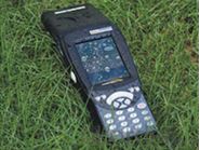
GIS S1
- Ref Price:
-

- Loading Port:
- China Main Port
- Payment Terms:
- TT OR LC
- Min Order Qty:
- -
- Supply Capability:
- -
OKorder Service Pledge
OKorder Financial Service
You Might Also Like


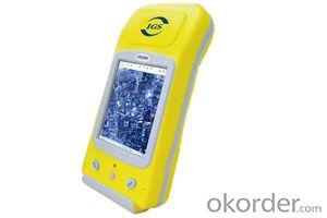
main function
High Performance in Accuracy
S750 can provide reliable location data.You can use it to do static work,also you can use it to do stop & go work.,after collecting data with built-in program,you can postprocess it in the office and get high-accuracy result.If you want to submeter performance in real time, you can use SBAS corrections, or use GPRS module to get a network differential correction from CORS.
High Expansibility
Generally, S750 adopts a built-in GPS antenna, but when do static work, you need an external GPS antenna, which can get high-accuracy result,S750 can switch between internal antenna and external antenna automatically. Apart from the above functions, S750 has good expansibility tools and forms can be customized by requirement.
Practical Software System
SOUTH S750,which owns a powerful 32-bit processor with 520MHz,runs the advanced Microsoft Windows CE.net 5.0 software which is used by the pocket PC operating system. Windows CE.net 5.0 operating system is an open platform, which is widely applied to industrial control,multimedia products and mobile devices,etc.
Thus, users can easily choose or customize a suitable software solutions. Windows CE.net 5.0 is similar to other Microsoft softwares, apart from this, users can easily exchange data seamlessly between field and office as well.
Excellent Engineering Performance
SOUTH S750 system combines the GPS receiver with handheld computer, which can be operated all-day. Built-in battery which is easy portability, whose industrial design be able to withstand the test of tough environment.
Handheld operating software and post-processing software are designed for convenient operation.It ensures that users can operate it with minimal training .
effective solution of mobile mapping.
Standard feature
System
Windows CE.net 5.0(classic edition)
VGA display (240 X 320), sunlight-readable color touch screen
Integrated Bluetooth wireless technology
Integrated 802.11b/g wireless LAN
Ergonomic cable-free handheld
Rugged and water-resistant design
All-day internally rechargeable Lithium battery
PXA270 520 MHz XScale processor
128MB RAM
128MB Flash data storage
Sealed SD/SDHC card slot
Integrated speaker and microphone
GPS
Integrated high-performance GPS/SBAS receiver and L1 antenna
GPRS module is available
Access various kinds of CORS
Submeter real-time or postprocessed accuracy
NMEA protocol support
EVEREST multipath restraining technology
Standard Kits
S750 receiver
Battery
Charger
Adapter
Communication cable
SD card kits
Manual & Software
Optional features
Optional Accessories
External antenna
GPRS module
Specification
Physical
Size:19cm×7.5cm×3.1cm
Weight:0.421Kg with battery
Processor:520 MHz PXA-270 Xscale processor
Memory:128MB RAM and 128MB internal Flash storage
Battery:3.7Volt 1700mAH Lithium battery pack
(3.7Volt 2350mAH high-capacity battery optional)
rechargeable button cell battery backup for data
retention(user accessible)
Environment
Operating temperature:-20°c~+60°c(-4°F ~140°F)
Storage temperature:-40°c~+70°c(-40°F ~158°F)
Casing:Dust-proof and resistant to heavy wind-driven
rain per IP65 standard Slip-resistant grip,
shock and vibration resistant
Input/Output
Expansion: SD card slot (SD or SDHC storage card)
Display: VGA(240×320pixel),TFT,16bit,colors with backlight
Audio:Built-in speaker with volume control
Screen: Touching screen is suitable for finger operation
GPS
Channels:14(12 L1 code and carrier, 2 SBAS)
Integrated real-time:SBAS (dual-channel tracking)
Update rate:1 Hz
Time to first fix:30~40 seconds
Protocols
Data output: NMEA-0183 (GGA, VTG, GLL, GSA, ZDA, GSV, RMC)
Accuracy (HRMS) after differential correction
Post-process: Submeter
Real-time (SBAS or external correction source): Submeter
- Q: My friend is in use, the difference is not big, professional handset (smart or Magellan bulky, but 3 case), but the price is expensive, but can not call and map is very rotten, endurance of 10 hours (dry battery) the mobile phone also has all the time. Know friends say, I mainly in the suburbs! Thanks
- Design ideas and the use of different objectsThe handheld is designed for military, mapping, mining, agriculture, outdoor sports (hiking, hiking, orienteering, cycling, water sports, paragliding, etc.).Cell phone navigation is designed to drive a car in the city, built-in interest points are mostly concentrated in the city.
- Q: Seeking the similarities and differences between RTK and GPS
- GPS: is the satellite positioning system in general, narrow sense refers to the GPS satellite, and the narrow sense refers to all can receive GPS signal equipment; RTK refers to the dynamic real time difference measurement, it also refers to the difference can be used for real-time dynamic measurement equipment. The difference between the two measurements from speaking: GPS contains RTK, also includes some precision lower grade equipment, such as the Garmin handset, handset, GPS meter level navigation etc..
- Q: What is the difference between industrial GPS handset and mobile navigation
- 3, professional handheld machine with industrial design. First of all, if used outdoors, then fell, and so on are likely to water, and this thing is also very expensive, so the opportunity to have a high professional anti shock waterproof performance.4, different screen design. If you look carefully, you can see in the outdoor light, mobile phone can not see the contents of the screen, while the professional handset is not the same, can see clearly in bright light, does not affect the work of foreign trade operations.
- Q: I bought the way k20s, this handheld GPS how
- Choi way handheld GPS feel that you can also be in the last year, the Zhengzhou Bureau of Surveying and mapping seems to be called the wide Han instrument that home to buy, so there is no problem with it, the price is not expensive.
- Q: GPS handheld function to measure it?
- Depends on the accuracy of the range you require, if the accuracy of the 3-5 meter can be used for ranging, measuring area, latitude and longitude, elevation information, etc.
- Q: I am a handheld GPS precision is low, how to use to be able to improve certain accuracy
- Look at the maximum accuracy of GPSIf the difference accuracy can reach 1cm you can connect CORS single base station and other network RTK way to achieve the corresponding accuracy
- Q: In addition to the parameters, that is the problem of the machine, what method can reduce the error of these two machines to a minimum. Because, at the same time to find a coordinate. The gap is too big.
- GPS was in error with 10 meters, with the star search results, related to the environment, if the precision is high, as long as the use of handheld GPS submeter or handheld RTK
- Q: I just bought a handheld GPS Magellan No. 1, showing the latitude and longitude coordinates, I want to set the geodetic coordinates of latitude and longitude, do not know where to set, I would like to ask you, how to set, there is a better picture shows the best, thank you so much.Magellan GPS 210 is not 2000 shy
- 1 position: [format setting unit - "[] position display format is set to User UTM Grid, and enter the relevant parameters, such as the 3 degree or 6 degree with the area with the central meridian projection, the ratio was 1, that deviation is 500000m, north-south deviation is 0.2 map reference setting: [[map] - unit "benchmark is set to User, and input the DX, DY, DZ, DA, DF parameters, usually DX, DY, DZ vary from region to region, so need to know the high level control points to solve, solving methods are as follows:The handheld GPS is placed in the control point field buried pile, were measured, and then hand coordinate coordinates and the known control points of the GPS measurements obtained for the poor, can be obtained by local coordinates and elevation deviation value: DX, DY, DZ.
- Q: What qualifications should a normal GPS locator have?
- You ask is handheld GPS, it is the manufacturer's qualification requirements or what. For example, business license, tax registration certificate, organization code certificate, vendor authorization, software copyright, precision test report, 3C certificate, ISO9001, industrial grade IP certificate and other relevant qualification certificates and documents
- Q: What is the difference between professional navigation and professional GPS navigator
- 3 map software is accurate, you can identify the road on the viaduct, and you can tip up and down viaduct."This should be no problem currently on the market of the navigation software is mainly three: Skywalker, Kai Lide, cityonmap. Three navigation software has its own advantages and disadvantages. I personally feel that the person with Skywalker more, some car navigation systems (non open operating system) OEM software with Kay more than cityonmap map Skywalker is better but the interface is not good.4 mobile phone PDA load or other independent GPS devices can be.
Send your message to us
GIS S1
- Ref Price:
-
- Loading Port:
- China Main Port
- Payment Terms:
- TT OR LC
- Min Order Qty:
- -
- Supply Capability:
- -
OKorder Service Pledge
OKorder Financial Service
Similar products


Hot products


Hot Searches

