
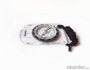


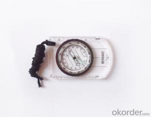
Transparant Map Compass DC35-B
- Ref Price:
-

- Loading Port:
- China Main Port
- Payment Terms:
- TT OR LC
- Min Order Qty:
- -
- Supply Capability:
- -
OKorder Service Pledge
OKorder Financial Service
You Might Also Like


Model: DC35-B
Name: Professional map compass, ruler compass
Product Origin: China
Supply Ability: 10,000 pcs/month
Minimum Order: 50 pcs
MOQ for OEM package: 500pcs
Product Size: 70*48*9 (mm)
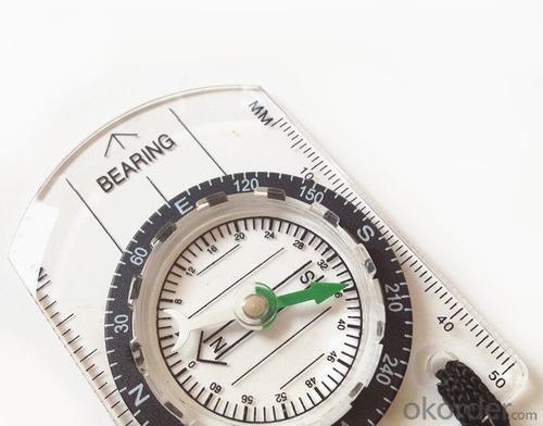
Features
1, professional usage: orientation, distance measuring, measuring slope, azimuth and pitching Angle measurement, drawing, a magnifying glass
2, high quality compass with neck rope, portable and rugged
3, ACRYLIC material, about 2mm thick
4, Damping Dial: to keep the stability of the pointer, more suitable for outdoor
environment.
5, Accuracy: accurate and clear, there were 360 degrees azimuth Angle, outer ring is 64-00 system, Liquid filled in the compass for reliable readings.
6, Magnifier function
- Q: Can you buy a good handheld GPS in China? FiveTrouble master recommended several professional handheld GPS brand, in addition to handheld GPS can speed it? Thank you!!
- In fact, the main function is to use navigation as long as the navigation function can be used
- Q: Seeking the similarities and differences between RTK and GPS
- GPS: is the satellite positioning system in general, narrow sense refers to the GPS satellite, and the narrow sense refers to all can receive GPS signal equipment; RTK refers to the dynamic real time difference measurement, it also refers to the difference can be used for real-time dynamic measurement equipment. The difference between the two measurements from speaking: GPS contains RTK, also includes some precision lower grade equipment, such as the Garmin handset, handset, GPS meter level navigation etc..
- Q: Can a handheld navigator connect a cell phone? Thank you
- Mobile navigator can downloadOther purchases can not beNow basically use the phoneEasy update and operation
- Q: I bought the way k20s, this handheld GPS how
- Choi way handheld GPS feel that you can also be in the last year, the Zhengzhou Bureau of Surveying and mapping seems to be called the wide Han instrument that home to buy, so there is no problem with it, the price is not expensive.
- Q: Handheld GPS brand rankings
- SIBAOIn the GNSS coordinate precision and attributes, "SIBAO" has a professional GPS handset, GIS i-PPP GIS, a mobile data collector, GIS, high precision GIS, high precision measurement of RTK complete product structure, to form a comprehensive solution to the spatial information industry scheme. Set of SIBAO products awarded the Beijing independent innovation product identification certificate, satellite navigation and Engineering Excellence Award and other professional awards. At the time, location, navigation and other comprehensive applications, Unistrong successful implementation of hundreds of large projects, services in many national key projects, won the national honor.MagellanGarmin
- Q: What is GPS Mu meter ah, with the general said that the GPS measuring instrument what is the difference?
- The amount of words on the handheld GPS, Magellan can be both economic and affordable.
- Q: How do I still stay in the GPS navigation, GPS monitoring of the primary idea? FiveBusiness services, thank you!Future business services
- 1 power, telecommunications, telecommunications and other network time synchronization2 accurate timing of admission3 accurate frequency of admission1 geodetic measurements of various levels2 Road and various line lofting3 underwater topographic survey4 crustal deformation measurement, dam and large building deformation monitoring5.GIS application6 construction machinery (tyre crane, bulldozer, etc.) control7 precision agricultureAt the present stage, it is mainly used for the security of vehicles and the management of personnel vehicles. With the continuous development of social economy, more and more vehicle users, GPS will gradually get wide application, on the stage of the car is enough for your service. Prospects can still be Lin Shijie GPS
- Q: Welcome to make comments on the existing GPS tour pal what shortcomings to answer the more detailed the better
- Fifth elements: the terrain map is the main project of outdoor sports climbing, mountain climbing is very exhausting, we usually do a plan will be completed on schedule, a good plan should be to our destination in the manual run out before. And if you want to do this, it must be on the road difficult to have a correct anticipation. But this time, with the terrain map GPS can come in handy, the mountains and the altitude of the understanding, we need to know about these sections spend much time and energy. And the general GPS map, is unable to meet the needs. So we'd better buy a map with contour terrain data of professional grade GPS, make your own outdoor journey do in our hands.
- Q: In addition to the parameters, that is the problem of the machine, what method can reduce the error of these two machines to a minimum. Because, at the same time to find a coordinate. The gap is too big.
- GPS was in error with 10 meters, with the star search results, related to the environment, if the precision is high, as long as the use of handheld GPS submeter or handheld RTK
- Q: How the German born handheld GPS Mu meter, I want to buy?
- Ergonomic design of lightweight and flexible dynamic appearance collocation black shell, the rear panel detector specially equipped with lights, emergency lights, more appropriate and practical, are small and easy to carry, dustproof, seismic, high temperature resistant, high capacity lithium battery long time power supply, full compliance with the harsh working environment.
Send your message to us
Transparant Map Compass DC35-B
- Ref Price:
-
- Loading Port:
- China Main Port
- Payment Terms:
- TT OR LC
- Min Order Qty:
- -
- Supply Capability:
- -
OKorder Service Pledge
OKorder Financial Service
Similar products


Hot products


Hot Searches

