
Professional GIS K200
- Ref Price:
-

- Loading Port:
- China Main Port
- Payment Terms:
- TT OR LC
- Min Order Qty:
- -
- Supply Capability:
- -
OKorder Service Pledge
OKorder Financial Service
You Might Also Like


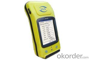
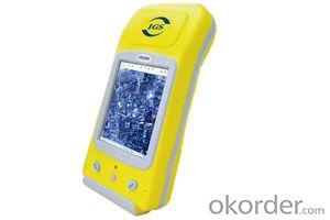
PJK-200
PJK-200 is the most versatile post-processing solution designed for easy and efficient land survey. PJK-200 solution includes the new GIS rugged GNSS receiver running Windows Mobile? 6.5 operating system, the new Field software and the new GISL1 GPS/GLONASS) antenna.
Outstanding GPS & GLONASS Performance
Thanks to the embedded IGS technology as well as GPS and GLONASS signals tracking, PJK-200 provides high-precision measurements even in very demanding or obstructed environments. Its exceptional post-processing performance and short occupation time deliver a very productive solution to the field crews.
Unpaired Ease-Of-Use
The very intuitive GIS Field software is designed for simple and trouble-free use providing all necessary tools without any unnecessary or complicated features. Lightweight, but rugged and waterproof handheld design, all-day-long autonomy, and large memory make PJK-200 a perfect solution for easy and efficient post-processing.
Versatile Solution
Designed as a scalable solution, PJK-200 can be easily upgraded to such capabilities as GLONASS, RTK or GPRS and be used not only in post-processing but also in RTK or GIS applications. Built on the state-of the-art Windows Mobile 6.5 based platform with embedded wireless communications, PJK-200 is a truly versatile and complete offering.
PJK-200- Specifications
Product specifications
· Constellation : GPS, GLONASS, SBAS
· Frequency : L1
· Channels : 45
· Update Rate : 0.05 sec
· Data format : RTCM 3.1, ATOM, CMR(+), NMEA
· Raw data output : Yes
· Real-time Accuracy - RTK mode (HRMS) : 1 cm
· Real-time Accuracy - DGPS mode (HRMS) : < 30 cm
· Real-time Accuracy - SBAS mode (HRMS) : < 50 cm
· Post-Processed Accuracy (HRMS) : 0.5 cm + 1 ppm
· Time to first fix : 15 sec
· Initialization range : Up to 10 km
· Processor : 806 MHz
· Operating system : Windows Mobile 6.5
· Communications : GSM/GPRS, BT, WLAN
· Unit size (mm / inches) : 190x90x43mm / 7.5x3.5x1.7in
· Weight : 0.62 kg / 1.43 lb
· Display : 3.5
· Memory : 256 MB SDRAM, 3 GB NAND, SDHC
· Temp Min (°C) : -20°C / -4°F
· Temp MAx (°C) : 60°C / 140°F
· Waterproof : Yes
· Shock & vibration : ETS300 019 / MIL-STD-810
· Power (type - lifetime) : 6600 mAh Li-Ion / > 8 hrs
· Antenna Type : Internal / External
· Firmware options : Yes
· Software options : Yes
- Q: Handheld GPS need to put the phone card?
- Hello, now the general GPS are required to put the card! Thanks
- Q: Is it accurate to measure highway mileage with GPS handheld
- Measuring mileage, since the unit has been upgraded to the inside, it is quite accurate oh
- Q: Mobile GPS can replace professional handheld GPS
- Ziphah measured Mu instrument, a key measurement area, the use of simple, SV-118, with high precision imported GPS module and antenna, accurate measurement, the block walk in a circle to measure the size and graphics trajectory, 550 yuan, USB charging, large capacity lithium battery, black and white screen to see the clear day for outdoor use.
- Q: Handheld GPS charge is not into electricity what is the reason
- Reason analysis:1, battery damage. 2, system failure. 3, charger reasons or bad contact.
- Q: My cell phone: HTC Hero 200Question type: Internet softwareMy work needs to locate, record, output, and input GPS coordinates. Track record measurement, coordinate transformation. So would you have a professional security software under the table, so go out with a mobile phone or a PAD, or N equipment back to survey the tired,
- Taobao to enter the online shopping, mobile phone navigator on the line, I suggest you download the Careland navigation map, or tiger map
- Q: I am a handheld GPS precision is low, how to use to be able to improve certain accuracy
- Look at the maximum accuracy of GPSIf the difference accuracy can reach 1cm you can connect CORS single base station and other network RTK way to achieve the corresponding accuracy
- Q: In addition to the parameters, that is the problem of the machine, what method can reduce the error of these two machines to a minimum. Because, at the same time to find a coordinate. The gap is too big.
- GPS was in error with 10 meters, with the star search results, related to the environment, if the precision is high, as long as the use of handheld GPS submeter or handheld RTK
- Q: Saying that we have a project in front of it is to do so, it is surprising that there are wood
- To 3D GPS it is not easy to find the map
- Q: Handheld GPS purchaseHandheld GPS navigator!Is mainly used for tourism, I said is not a mobile phone, is a more professional handheld GPS navigator for travel outside! Handheld GPS navigator can voice navigation?
- The more high-end is good, clever and wheat zalun, many outdoor enthusiasts are used to this, hiking, cycling and other applications are relatively wide, is an American brand, Mazelen returned to the U.S. Army GPS, and as Ma Ying-Jeou ring when riding on the handlebar also puts a high out of this two 60CSX. the brand in the nature, the price is more expensive, in more than 2000, but the best is to the store to buy.
- Q: What qualifications should a normal GPS locator have?
- Look at his company's business license is what's on the line, if the manufacturer has the most basic 3C proved, and some such as system certification or proof of what the explosion proof CEPREI
Send your message to us
Professional GIS K200
- Ref Price:
-
- Loading Port:
- China Main Port
- Payment Terms:
- TT OR LC
- Min Order Qty:
- -
- Supply Capability:
- -
OKorder Service Pledge
OKorder Financial Service
Similar products


Hot products


Hot Searches
Related keywords

