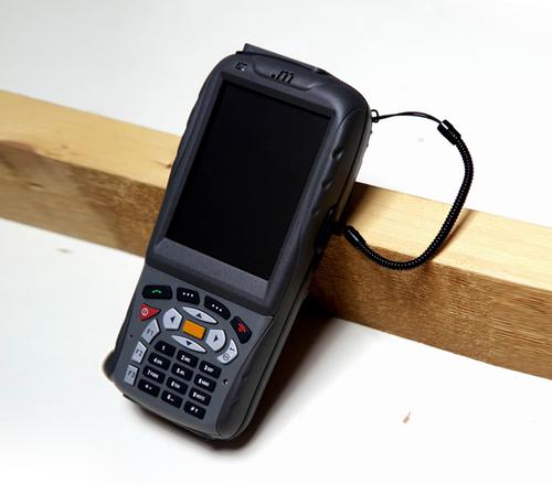
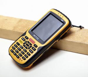
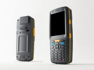
Industrial Windows PDA MT02
- Loading Port:
- China Main Port
- Payment Terms:
- TT OR LC
- Min Order Qty:
- -
- Supply Capability:
- -
OKorder Service Pledge
Quality Product, Order Online Tracking, Timely Delivery
OKorder Financial Service
Credit Rating, Credit Services, Credit Purchasing
You Might Also Like
Specification:
| Hardware | |||||
| Core board | |||||
| WM6.1/6.5 OS | option 1 | Marvell PXA310(624MHz)+qualcomm (GSM band 900/1800/1900MHz, GPRS, EDGE/WCDMA 2100MHz HSDPA 3.6Mbps) | |||
| Win CE 6.0 | option 2 | Marvell PXA310(624MHz) ( NO Communication function) | |||
| Android 2.3 OS | option 3 | Marvell PXA910(806MHz)+qualcomm (GSM Quad-band 850 /900 /1800 /1900 MHz, GPRS, EDGEWCDMA 3G 900/1710/2100MHz HSDPA 3.6Mbps | |||
| Memory | Flash ROM | 512MB | |||
| RAM | 512MB DDR (WM os is 256MB) | ||||
| Extend Slot | Micro SD 16G (SDHC) | ||||
| Motherboard | |||||
| Display | 3.2inch TFT LCD (Transflective screen QVGA) | ||||
| touch screen | 4-wire resistive | ||||
| Form Factor | Bar type classical Pocket PC,Industrial appearance | ||||
| GPS | Qualcomm chipset (WM OS) | ||||
| UBLOX module (Android OS ) | |||||
| Bluetooth | Bluetooth SIG version 2.0 compliant; Supported profiles: headset, hands-free, object push, serial port, dial-up network | ||||
| WiFi | WiFi (802.11 b/g) | ||||
| RFID Reader | option 1 | HF RFID(13.56MHz ISO 14443A/B) | |||
| option 2 | HF RFID(13.56MHz ISO 14443A/B ISO 15693) | ||||
| option 3 | NFC Reader ( only Android OS ) , ISO14443A/B,ISO15693 | ||||
| barcode scanner | YES | NEWLAND:EM1300(1D infrared barcode reader--cost-effective ) | |||
| option 2 | NEWLAND:EM3000(1D&2D barcode reader -- Hardware decode ) | ||||
| option 3 | symbol:SE955(1D laser barcode reader) | ||||
| option 4 | HoneyWell:N4313 (1D laser barcode reader) | ||||
| option 5 | Honeywell:5100(1D&2D barcode reader -- Software decode ) | ||||
| option 6 | Symbol: SE4500(1D&2D barcode reader -- Software decode ) | ||||
| External Interface | USB HOST/RS232(Customized) | ||||
| Protection class | IP54 | ||||
| Drop resistance level | 1.5m | ||||
| Camera Function | Camera | 5MP | |||
| Video | Support still image and video capture | ||||
| Keypad | Front | 30keys | |||
| Side | 4keys | ||||
| Interface | Mini-USB connector | USB2.0 connection | |||
| SIM card slot | Yes | ||||
| PSAM card slot | optional | ||||
| TF card slot | Yes | ||||
| power jack | Yes | ||||
| Audio Jack | Yes | ||||
| Battery | Type | rechargeable Li-ion battery 3100mAh | |||
| Standby Time | 500hours | ||||
| Calls Time | Up to 6hours | ||||
| Charging Time | 4 hours | ||||
| Physical Characteristics | Dimension | 149*72*28mm | |||
| Weight | >300g with battery (according config) | ||||
- Q: Can you buy a good handheld GPS in China? FiveTrouble master recommended several professional handheld GPS brand, in addition to handheld GPS can speed it? Thank you!!
- In fact, the main function is to use navigation as long as the navigation function can be used
- Q: Can a handheld navigator connect a cell phone? Thank you
- Now basically use the phoneEasy update and operation
- Q: Want to buy handheld GPS in Hongkong, I would like to ask what brand is better, the specific model? Where to buy? How much is the price? In the mainland can be used? More questions, thank you!
- I doubt this question will be answered by the people of Hongkong?Handheld GPS do best is GARMIN, Taiwan and the mainland are agents. It's all the same.
- Q: What is the difference between a hand-held GPS and a car's onboard navigator
- As the first floor of a friend to answer the same, the general application of hand-held devices in land surveying, mountain climbing and other precise positioning when measuring the use of. Long standby time, three good performance. Easy to carry. A single charge can be used for a long time (depending on the machine). Although navigation, but the map is not detailed. At the same time, there is an opportunity to have latitude, latitude and other information.The car navigation is designed for users to drive out, in the field when not familiar with the road, ah, not familiar with the surrounding buildings, such as parking, hospitals, restaurants, gas stations. Used. Map details. But does not provide information such as latitude accuracy. No elevation.Look what you're doing. There is also a mobile phone navigation function.If you are purely for entertainment, then choose the phone.If you want to navigate in the car, select the vehicle navigation.If you are a very professional outdoor sports enthusiasts on the choice of handheld.
- Q: How do I still stay in the GPS navigation, GPS monitoring of the primary idea? FiveBusiness services, thank you!Future business services
- Mainly for the ship, automobile, aircraft and other moving objects positioning navigation. For example:1 ocean navigation and incoming water diversion2 aircraft route guidance and approach landing3 vehicle autonomous navigation4 ground vehicle tracking and urban intelligent traffic management5 emergency rescue
- Q: What do you need to test for GPS?
- As a high-tech product, GPS has a very complex technical parameters. However, as people's living standards improved rapidly, more and more ordinary people began to pay attention to the positioning and navigation tools originated from the military. Because the convenience it brings is unprecedented. In order to let everyone out of all the technical parameters of GPS receiver, no longer confused at the time of purchase, the author selected six of the most important technical indicators, one by one to explain to you. 1 parallel channels on the market most of the GPS receiver is a 8 channel, 12 channel, the 16 channel, which allows them to continuously track the information of each satellite. Some GPS devices only have 2 to 5 parallel channel receiving satellite signals, because the average of 8 satellites are visible, which means that the GPS receiver must visit each of the satellites in order to obtain information about each satellite. All of our products are in Shenzhen channel 16 channel, multi-channel parallel GPS receiver, including the advantages of rapid cold start and initialization of satellite information, but also in the forest area can have a better reception. General 12 channel receiver does not require an external antenna, unless you are in a bad environment conditions such as closed space, such as the cabin, the car. 2 the sensitivity of the GPS satellite signal to the ground has been very weak, as well as ground wireless communication clutter interference. The lowest traceable signal strength of the GPS receiver determines how much useful signal is received. A GPS receiver with a lower minimum tracking signal strength has a higher sensitivity, and can receive more available satellites under bad conditions
- Q: I am a handheld GPS precision is low, how to use to be able to improve certain accuracy
- If the carrier phase measurement function is not available, you have the maximum accuracy of GPS accuracy of 1-10This can only improve the observation environment using SBAS and other ways to improve the accuracy
- Q: In addition to the parameters, that is the problem of the machine, what method can reduce the error of these two machines to a minimum. Because, at the same time to find a coordinate. The gap is too big.
- GPS was in error with 10 meters, with the star search results, related to the environment, if the precision is high, as long as the use of handheld GPS submeter or handheld RTK
- Q: Fuxin coordinates with the mapping of the seven parameters are what ah there is no professional knowledge to tell my brother I need to fill the gps... Thanks.
- Handheld GPS has not been used, you can find three known control points, try to solve.
- Q: How to hand GPS eTrex H data to the computer
- Computer installed on the MapSource software, connect the data cable, upload waypoints and tracks can be!
Send your message to us
Industrial Windows PDA MT02
- Loading Port:
- China Main Port
- Payment Terms:
- TT OR LC
- Min Order Qty:
- -
- Supply Capability:
- -
OKorder Service Pledge
Quality Product, Order Online Tracking, Timely Delivery
OKorder Financial Service
Credit Rating, Credit Services, Credit Purchasing
Similar products
Hot products
Hot Searches
Related keywords


