
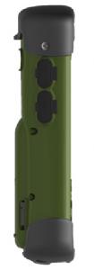
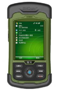
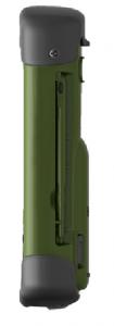
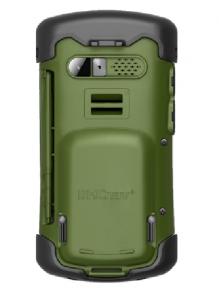


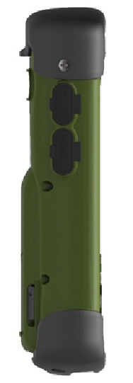
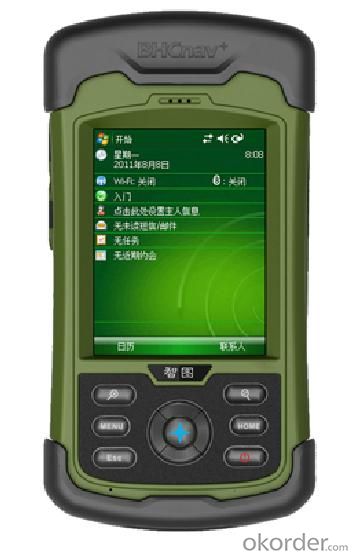
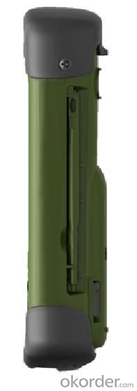
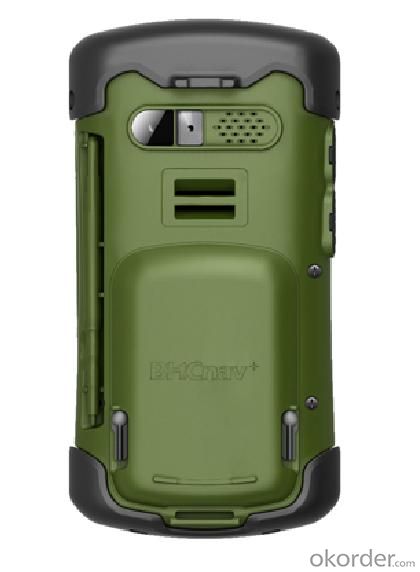
M50 GIS DATA COLLECTOR
- Ref Price:
-

- Loading Port:
- China Main Port
- Payment Terms:
- TT or LC
- Min Order Qty:
- 10 unit
- Supply Capability:
- 1000 Sets per Month unit/month
OKorder Service Pledge
OKorder Financial Service
You Might Also Like


M50 GIS DATA COLLECTOR
Premium, rugged, handheld GPS with camera, microphone, and speaker to record all your actions and navigate the outdoors
+3 mega-pixel Camera
+Built-in Barometric altimeter, E-compass, etc.
+3.5 Inch Touch Screen
+Integrated high-sensitivity multidirectional GPS antenna
Specification:


Remarks:
1. Specifications subject to change without notice.
2. Accuracy and reliability depend on the quality of GPS signal and working environment.
3. Battery life time and charge cycles will vary with conditions and environment of use.
4. Software may vary depending on configuration.
5. Weight varies from configurations and optional accessories.
Certificates:

Standard Packing:
GISA device(M50 GIS DATA Collector)
•Li-ion battery
•AC power adapter
•USB cable
•Handheld strap
•Stylus pen with string
•Screen protector
•Quick guide
•Inspection card
•CD
•4G micro SD card
Application:

Utilities: Underground asset mapping and inspection, water network modelling, as-built mapping of lines/cable installations, and incident/outage reporting.
Local government: High-density urban asset mapping, underground asset relocation, municipal asset inventory and inspection.
Environmental management: Weed management, water debris management, pollution mapping, environmental incident mapping, sample gathering, agricultural subsidy determination.
Warranty Period:
12 months after the delivery time from our factory for our M50 GIS Data Collector.
After Sale Service:
After Sale, We provide free technical support via e-mail, skype chatting, telephone or video if necessary for our M50 GIS data collector. Or you could also dispatch your engineers to our company, we can offer free training face to face. You should please bear the air tickets and all costs when staying in China. We offer additional accessories if you need. But the additional accessories will be charged.
Notices:
1. All our field software free of charge.
2. We have most of our products in stock and samples are available.
3. MOQ is one set.
4. For large quantity, we accept OEM production(printing customer's logo on the products)
Delivery :

- Q: Can you buy a good handheld GPS in China? FiveTrouble master recommended several professional handheld GPS brand, in addition to handheld GPS can speed it? Thank you!!
- The main function is to use navigation as long as the navigation function can be used
- Q: Seeking the similarities and differences between RTK and GPS
- RTK full name is GPS-RTK real-time dynamic distribution, which you know.
- Q: Handheld GPS which brand is good
- Now GPS can also do handheld measurement accuracy, precision can usually reach decimeter level, the industry there are relatively well-known Huace, professional GPS measurement instrument, high precision of handheld GPS the good.
- Q: Verify the accuracy of the GPS device to buy back, the way is to use Android under the'gps state 'software, to test the accuracy of real-time single point positioning.1 with two sets of the same Android Tablet Computer (custom machine, type of bad) in the same position for receiving, find that the accuracy is the same (software, are 1-2 meters), but the position would be poor 10 meters or more. It's in the same place.The 2 one is the Android tablet computer, a mobile phone is HTC G10, also received together in the same position, find that the accuracy is not the same as (the latter 20 meters or so), but also may be about 10 meters position difference.The accuracy of this GPS device can reach 1-2 meters, while the same location in real-time single point positioning error of 10 meters, a reasonable explanation.
- 10 meters.To the world in 2013 a total of four global satellite navigation system, in addition to the United States has been in the mature GPS system and commercial operation, the Beidou system, China the European Galileo system, the Russian GLONASS system are still under construction. "The Galileo satellite navigation project" was first conceived by the 30 satellite GPS network to compete with the United States, the beginning of the design proposed in 2008 formally put into operation, and later postponed to 2014, the entire system is only 4 satellites in orbit (as of 2012), in fact it is mainly used to further verify the relevant design and the working system of the system design, after the official start of Galileo satellite will launch. Formal networking satellites are being prepared. China satellite navigation system management office senior engineer Yang Qiangwen introduction, to 2012, the "system" in orbit satellites are also only verify satellite.
- Q: What is the difference between a hand-held GPS and a car's onboard navigator
- As the first floor of a friend to answer the same, the general application of hand-held devices in land surveying, mountain climbing and other precise positioning when measuring the use of. Long standby time, three good performance. Easy to carry. A single charge can be used for a long time (depending on the machine). Although navigation, but the map is not detailed. At the same time, there is an opportunity to have latitude, latitude and other information.The car navigation is designed for users to drive out, in the field when not familiar with the road, ah, not familiar with the surrounding buildings, such as parking, hospitals, restaurants, gas stations. Used. Map details. But does not provide information such as latitude accuracy. No elevation.Look what you're doing. There is also a mobile phone navigation function.If you are purely for entertainment, then choose the phone.If you want to navigate in the car, select the vehicle navigation.If you are a very professional outdoor sports enthusiasts on the choice of handheld.
- Q: Welcome to make comments on the existing GPS tour pal what shortcomings to answer the more detailed the better
- Fifth elements: the terrain map is the main project of outdoor sports climbing, mountain climbing is very exhausting, we usually do a plan will be completed on schedule, a good plan should be to our destination in the manual run out before. And if you want to do this, it must be on the road difficult to have a correct anticipation. But this time, with the terrain map GPS can come in handy, the mountains and the altitude of the understanding, we need to know about these sections spend much time and energy. And the general GPS map, is unable to meet the needs. So we'd better buy a map with contour terrain data of professional grade GPS, make your own outdoor journey do in our hands.
- Q: How about the accuracy of the GPS handset?
- Zhonghaida Q1:2 zhonghaida Q5:1 meters; meters; zhonghaida Q6: decimeter; zhonghaida Q8 cm;
- Q: Magellan GPS handheld why so many people choose not to say that the map is not good
- Outdoor use three times a year also on the trip, but also want to use both sides can be used to the best, so these are the best of the two Ming and Magellan did not know that the election of the good, but I am willing to build businesses with the best Ming of the 450.Chasing the answerIf only in the city with less than 610510 can be upgraded Magellan navigation, 610 more than and 510 three axis electronic compass if you don't like the original forest does not receive any signal where there is no whatTake a look at yourself
- Q: Handheld GPS each brand has what difference; different price difference in where is the positioning accuracy is different or what function is not the same?What are the differences between the measurements and the cars?
- Engage in measurement and what is the difference between the car I do not know, look at the car to see if the functionSMS + Mobile Internet + computer network platform! 3 ways to check the car!
- Q: What qualifications should a normal GPS locator have?
- Patent, business licenseLook what kind of
1. Manufacturer Overview
| Location | Beijing, China |
| Year Established | 2004 |
| Annual Output Value | Below US$1 Million |
| Main Markets | Mid East; Northern Europ;Africa; Southeast Asia |
| Company Certifications | RoHS;CE;FCC;CCC;ISO |
2. Manufacturer Certificates
| a) Certification Name | |
| Range | |
| Reference | |
| Validity Period |
3. Manufacturer Capability
| a) Trade Capacity | |
| Nearest Port | Tianjin; Qingdao |
| Export Percentage | 1% - 10% |
| No.of Employees in Trade Department | 500-999People |
| Language Spoken: | English; Chinese |
| b) Factory Information | |
| Factory Size: | Above 50,000 square meters |
| No. of Production Lines | Above 8 |
| Contract Manufacturing | OEM Service Offered;Design Service Offered |
| Product Price Range | High;Average |
Send your message to us
M50 GIS DATA COLLECTOR
- Ref Price:
-
- Loading Port:
- China Main Port
- Payment Terms:
- TT or LC
- Min Order Qty:
- 10 unit
- Supply Capability:
- 1000 Sets per Month unit/month
OKorder Service Pledge
OKorder Financial Service
Similar products


Hot products


Hot Searches
Related keywords

