


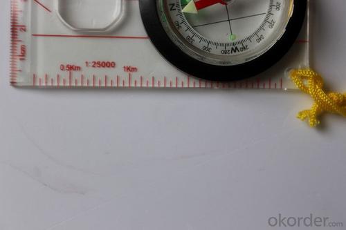


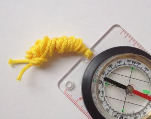
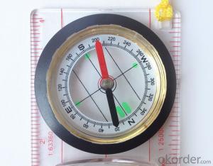
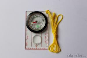
Map Scale Compass DC45-5W with Ruler
- Ref Price:
-

- Loading Port:
- China Main Port
- Payment Terms:
- TT OR LC
- Min Order Qty:
- -
- Supply Capability:
- -
OKorder Service Pledge
OKorder Financial Service
You Might Also Like


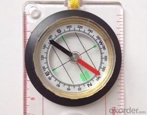
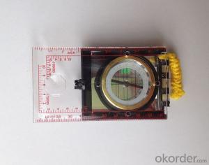
Model: DC45-5W
Name: Professional map compass, ruler compass
Product Origin: China
Supply Ability: 10,000 pcs/month
Minimum Order: 50 pcs
MOQ for OEM package: 500pcs
Product Size: 114*60.5*17 (mm)
Features
1, professional usage: orientation, distance measuring, measuring slope, azimuth and pitching Angle measurement, drawing, a magnifying glass
2, high quality compass with neck rope, portable and rugged
3, ACRYLIC material, about 2mm thick
4, Damping Dial: to keep the stability of the pointer, more suitable for outdoor
environment.
5, Accuracy: accurate and clear, there were 360 degrees azimuth Angle, outer ring is 64-00 system, Liquid filled in the compass for reliable readings.
Payment term: TT/ LC
- Q: I would like to ask the GPS handset and GPS receiver (Surveying and mapping qualification application needs) is there a difference? If yes, what is the difference?
- This is the case, GPS handheld refers to a thin hand, while the GPS receiver refers to the RTK host, equivalent to the base station in our industry said. The general application of Surveying and mapping qualifications are required for this application, referred to as RTK (1+1) set, level, theodolite, total station, walkie talkie, technical personnel.... And so on, are essential equipment.
- Q: Handheld GPS buried in the soil there is a signal
- It depends on how deep you buried the darker the GPS signal, and must ensure that the GPS antenna upward, the above can not be covered with metal objects
- Q: How to set the handheld GPS related parameters and coordinate conversion parameters throughout the country
- Three parameter test DX, DY, DZ, DA, DF after the conversion parameters of the five, must be prompted to enter the handheld GPS, while the input area of the central meridian longitude. E on behalf of the east longitude, projection ratio of 1, the deviation of things to the north and south of the deviation of 0, and set the unit for M. Enter these parameters, should be taken to the field test, check whether these five parameters are correct. The method is selected, vision, GPS receiving signal strength of the feature points in the field (such as linear object intersections, independent features, etc.) is the best stone control points were measured and compared with theory and find out the coordinates of these points. If the results of the comparison exceed the nominal accuracy of the instrument, the conversion parameters or the problems that should be found should be recalculated.
- Q: Seeking the similarities and differences between RTK and GPS
- GPS: is the satellite positioning system in general, narrow sense refers to the GPS satellite, and the narrow sense refers to all can receive GPS signal equipment; RTK refers to the dynamic real time difference measurement, it also refers to the difference can be used for real-time dynamic measurement equipment. The difference between the two measurements from speaking: GPS contains RTK, also includes some precision lower grade equipment, such as the Garmin handset, handset, GPS meter level navigation etc..
- Q: Can a handheld navigator connect a cell phone? Thank you
- Open the phone hotspot WiFi, handheld navigator connected to this wifi.
- Q: What is the difference between professional GPS handsets and mobile navigation?
- Mobile phones are used for network navigation, no network will not work, professional GPS navigation satellite navigation,
- Q: Handheld GPS which brand is good
- Now GPS can also do handheld measurement accuracy, precision can usually reach decimeter level, the industry there are relatively well-known Huace, professional GPS measurement instrument, high precision of handheld GPS the good.
- Q: Verify the accuracy of the GPS device to buy back, the way is to use Android under the'gps state 'software, to test the accuracy of real-time single point positioning.1 with two sets of the same Android Tablet Computer (custom machine, type of bad) in the same position for receiving, find that the accuracy is the same (software, are 1-2 meters), but the position would be poor 10 meters or more. It's in the same place.The 2 one is the Android tablet computer, a mobile phone is HTC G10, also received together in the same position, find that the accuracy is not the same as (the latter 20 meters or so), but also may be about 10 meters position difference.The accuracy of this GPS device can reach 1-2 meters, while the same location in real-time single point positioning error of 10 meters, a reasonable explanation.
- Oh the single point positioning accuracy is about 10 meters, but also have a great relationship with the environment around you, if in the city, the accuracy of twenty meters are possible, if the open place, outside. Ten meters should not be a problem. Whether you use a professional measurement RTK or ordinary navigation handheld machine, single point positioning accuracy can reach 1-2 meters of the machine I is not met, if you see where I wish to share with me, thank you. Can only say that the use of professional measurement RTK will certainly be higher than the navigation accuracy of GPS single point oh
- Q: I am a handheld GPS precision is low, how to use to be able to improve certain accuracy
- If the carrier phase measurement function is not available, you have the maximum accuracy of GPS accuracy of 1-10This can only improve the observation environment using SBAS and other ways to improve the accuracy
- Q: What is the difference between professional navigation and professional GPS navigator
- 5 price of less than 3000 yuan.> 4, 5 a answer: there are PDAGPS mobile phone development, but should be more than 6000. One of the PDAGPS generally above 3000, generally have more than 3000 car navigation. If you have Bluetooth support PDA or PDA phone, plus a Bluetooth GPS is as long as 1000 or so. So the first three choices and then you have only the following three choices: first, the new machine but the older models, businesses dumped, and the other is to know the people, and the three is a vintage.More well-known brands in the market: Taiwan (MIO), the new branch, Taiwan HOLUX long days, GARMIN, HP, etc.PDAGPS mobile phone: MIO A700, E, TATO588, HP6515PDAGPS development: MIO168, 169, 269, P350, HOLUX PolarisVehicle navigation: MIO C210, new section four or five, GARMIN three or four
Send your message to us
Map Scale Compass DC45-5W with Ruler
- Ref Price:
-
- Loading Port:
- China Main Port
- Payment Terms:
- TT OR LC
- Min Order Qty:
- -
- Supply Capability:
- -
OKorder Service Pledge
OKorder Financial Service
Similar products
Hot products


Hot Searches
Related keywords

