
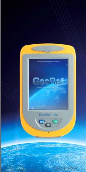
GIS V2
- Ref Price:
-

- Loading Port:
- China Main Port
- Payment Terms:
- TT OR LC
- Min Order Qty:
- -
- Supply Capability:
- -
OKorder Service Pledge
OKorder Financial Service
You Might Also Like


V2 series, a professional high-performance GIS data collector, applies advanced high-accuracy differential augmentation algorithm to provide post-processing enhanced differential function. With high-end mainstream hardware configurations, GeoRef V2 series supports large-size raster image data (up to 10GB) loading and 100 megabyte (MB) level vector data loading, and helps you achieve higher accuracy and better resolution for various applications in an effective and reliable way.
GeoRef V2 series, which is compatible with the international main-stream GIS platforms especially KQ GIS, offers overall GPS/GIS solution. Furthermore, KQ GEO could also offer users customized applications and functions to meet different requirements.
High-level System Configuration
◆ Industry-grade integrated design
◆ Windows CE 6.0 operating system
◆ 1GHz industry-grade mobile processor
◆ 256/512MB memory, 512MB flash memory
Integrated both Survey and Navigation GPS Receivers
◆ Integrated high-accuracy survey GPS receiver
◆ Integrated high-performance navigation GPS receiver
◆ Support SBAS (WAAS, EGNOS, MSAS)
◆ Built-in high-sensitive and anti-jamming GPS antenna
Integrated 2G/3G Wireless Communication
◆ Built-in industry-grade 2G/3G wireless communication modem
◆ Achieve high-accuracy positioning result by directly receiving differential data from reference station (CORS)
◆ Support data exchange between the server center and mobile GPS terminal
Integrated Bluetooth and WiFi Wireless Communications
◆ Built-in Bluetooth and WiFi wireless communication modems
◆ Stable short distance wireless data transmission
Integrated 3D Electronic Compass
◆ Effective assistance to GPS fieldwork
◆ High-speed and high-accuracy A/D conversion
◆ Zero pointing correction
Industry-grade Design
◆ Industry-grade integrated design with multi-functions
◆ IP67 waterproof and dustproof design against 1.5m natural drop
Visual Digital Image
◆Built-in high resolution camera supports on-site image acquisition and annotation
◆ Automatically matching GPS coordinates with image attributes
◆ Built-in microphone supports on-site audio acquisition and annotation
Professional Fieldwork Collection Software
GeoPac is the latest multifunctional GNSS data collection, processing and management software, containing data collection, edition, detection, analysis and storage, which is widely applied in different fields such as land supervision, water census, forestry inspection and etc.
◆ Comprehensive functionalities, meeting both requirements of high-accuracy engineering survey and field data collection.
◆ High-accuracy rapid positioning, meeting different accuracy requirements.
◆ User-friendly interface makes heavy-duty fieldwork easy and convenient.
◆ Universal coordinate systems with the popular Gauss, UTM, Mercator projection, etc.
◆ Various convenient coordinate transformation tools, making plane 4-parameter, spatial 7-parameter and 3-parameter transformation easier.
◆ Multiple professional data collection methods.
◆ Complete attributes library and easy setup make data collection, edition and management super-easy, greatly increasing fieldwork efficiency
- Q: Highway measurement with GPS I do not know which of the base station settings and mobile station settings I are very vague, to the instrument to build a coordinate system how to build the relevant issues to me
- For long tunnels, the conventional measurement of large bridges has the following limitations:1, long tunnels, bridges and other structures generally require the measurement level of four or more. With conventional measurement methods, often adopt the measure to increase the number of methods to extend the observation time, time consumption and labor consumption to try to improve the accuracy of.2, the long tunnel and bridge for the complex terrain region difficult, conventional control measure for visibility and network shape, often cut down the workload is quite large, so the measurement of the cost of a large, hard work.Link control network of high precision 3, long tunnel and bridge and low precision and route network, although with adjustment methods can be overcome, but because of the terrain conditions are difficult, the measurement workload to its connection, and is not too easy. In practical work, the control of the structure and the measurement of the route are often out of touch.
- Q: I would like to ask the GPS handset and GPS receiver (Surveying and mapping qualification application needs) is there a difference? If yes, what is the difference?
- GPS handheld GPS operating manual, GPS receiver is to receive satellite signals, GPS consists of two components.
- Q: Handheld GPS buried in the soil there is a signal
- It depends on how deep you buried the darker the GPS signal, and must ensure that the GPS antenna upward, the above can not be covered with metal objects
- Q: Handheld GPS navigation is what? Where to buy handheld GPS navigation, how to select GPS navigation?
- Select the main consideration of the following issues on the line:1, GPS receiving capacity, in the interior, the streets can be measured on a few stars, while looking at the speed of the search star? If a place for 2 - 3 minutes accurate positioning can be used2, the map is the latest, often used to check those routes3, battery life is how long to ask4, accessories, such as support, car charge, the size of the memory card should be clearly presentedThe location of the purchase is usually in the car decoration department or the electronic mall or digital products store salesAffordable mall can look at the old brand, operating for many years, where I bought the electronic dog
- Q: Seeking the similarities and differences between RTK and GPS
- GPS is a satellite system of the United States, is a kind of GNSS, GPS is widely used in surveying and mapping, the use of static and dynamic, RTD, dynamic RTK, RTK is a real-time dynamic difference, the accuracy of centimeter level, that is to say RTK is a GPS application method
- Q: I am a handheld GPS precision is low, how to use to be able to improve certain accuracy
- If the carrier phase measurement function is not available, you have the maximum accuracy of GPS accuracy of 1-10This can only improve the observation environment using SBAS and other ways to improve the accuracy
- Q: The navigation module it is "selph" three generation? Another one I mainly use it to measure the land area, easy to use, the error is not big?I want to buy Magellan 500 do not know whether it is good to use
- Can only use professional GPS measuring instrument! Magellan and SIBAO!
- Q: How to hand GPS eTrex H data to the computer
- Computer installed on the MapSource software, connect the data cable, upload waypoints and tracks can be!
- Q: Magellan GPS handheld why so many people choose not to say that the map is not good
- Magellan GPS handheld maps are not even, it is said that the map even money! No need ah.
- Q: How to upgrade handheld navigator
- Recommend the use of mobile map navigation.Chasing the answerEasy upgrade.
Send your message to us
GIS V2
- Ref Price:
-
- Loading Port:
- China Main Port
- Payment Terms:
- TT OR LC
- Min Order Qty:
- -
- Supply Capability:
- -
OKorder Service Pledge
OKorder Financial Service
Similar products


Hot products


Hot Searches

