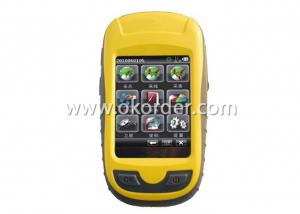

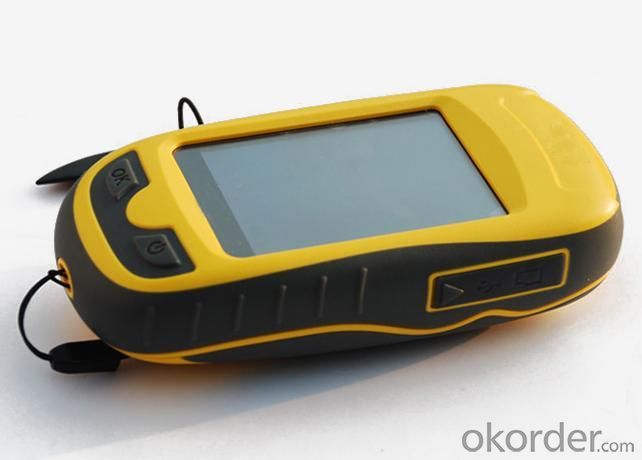
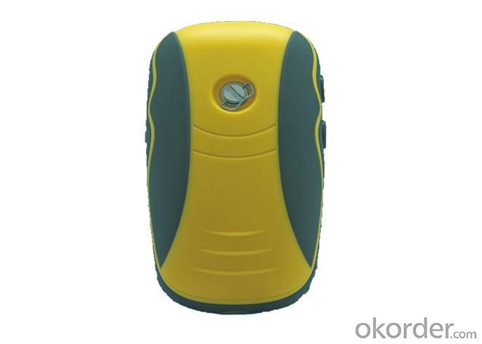
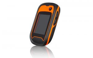
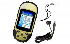
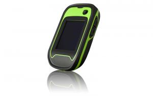
Professional Handheld GPS for Survering
- Ref Price:
-

- Loading Port:
- China Main Port
- Payment Terms:
- TT or LC
- Min Order Qty:
- 5 Sets set
- Supply Capability:
- 200 Sets Per Day set/month
OKorder Service Pledge
OKorder Financial Service
You Might Also Like


Specifications of Professional Handheld GPS for Surveying
Software | |
System configuration | Operating system: Windows CE intelligent system |
Processor: 533MHZ main frequency | |
Memory:2G high-capacity memory | |
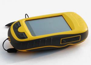
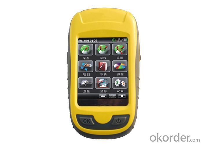
Display:2.8 inch, color touch screen | |
Software configuration | Intelligent handheld GPS collecting software |
Support the third party software installation application | |
Support SDK the second software development | |
GPS characteristics | High sensitive GPS positioning |
Support SBAS (WASS/EGNOS/MSAS) | |
Initial positioning time:30 seconds | |
Positioning accuracy | Single point positioning:5M |
SBAS:3M | |
Function | |
Application function | GIS function |
Map(zmp format) | |
Compass | |
Barometric altimeter | |
Temperature gauge | |
Data communication | USB interface |
Micro SD card slot | |
Bluetooth | |
Physical | |
Power source | Two AA batteries |
Over 10 hours' continuous work | |
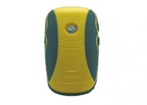
Physical characteristics | Weigh:150g(without battery) |
Size:127×66 ×37mm | |
Working temperature: -30℃~ +70℃ | |
Storage temperature: -40℃~ +80℃ | |
Dustproof and waterproof: Ip67 | |
Shock: anti 1.5m free fall | |
Operation Interface of Professional Handheld GPS for Surveying

Application Area of Professional Handheld GPS for Surveying
1.Forest 2.Navigation
3.Electric power 4.Water conservancy
5.Land resources 6.Municipal administration

Certificates of Qcool Professional Handheld GPS for Surveying

Workshop of Professional Handheld GPS for Surveying

Testing Equipments of Professional Handheld GPS for Surveying

Shipment of Professional Handheld GPS for Surveying

- Q: Handheld GPS positioning, can be directly uploaded to the computer, and the computer has a scalable map to mark the upload point. The above system, now there are 20Such as the title, I want to achieve the final function: through the manual to a point, with a hand-held GPS locator will be recorded in the specific latitude and longitude, and sent to the network in real time, for my computer to mark these points on the map. If you can directly enter the site of some of the information, directly to the above is the bestIf you have the above equipment, please indicate the scientific name, and the specific application industry.Thanks.
- 13 support GPS satellite positioning function, the need to connect GPS satellite positioning hardware devices (USB GPS devices or Bluetooth GPS devices; tablet PC).14 support offline map pack custom download function, you can download the map anywhere in the world.
- Q: Handheld GPS need to put the phone card?
- Hello, now the general GPS are required to put the card! Thanks
- Q: Handheld GPS brand rankings
- SIBAOIn the GNSS coordinate precision and attributes, "SIBAO" has a professional GPS handset, GIS i-PPP GIS, a mobile data collector, GIS, high precision GIS, high precision measurement of RTK complete product structure, to form a comprehensive solution to the spatial information industry scheme.
- Q: Jia Ming etre20 handheld GPS good
- The new generation of the eTrex series is the first generation of user level receivers that can track both GPS and GLONASS satellites. GLONASS global navigation satellite system developed by Russian Federation, fully put into use. When using the GLONASS satellite, the average time for the receiver to lock the target is about 20% faster than GPS. And, when using both GPS and GLONASS, the receiver has the ability to lock more than 24 satellites as compared to GPS alone.
- Q: Verify the accuracy of the GPS device to buy back, the way is to use Android under the'gps state 'software, to test the accuracy of real-time single point positioning.1 with two sets of the same Android Tablet Computer (custom machine, type of bad) in the same position for receiving, find that the accuracy is the same (software, are 1-2 meters), but the position would be poor 10 meters or more. It's in the same place.The 2 one is the Android tablet computer, a mobile phone is HTC G10, also received together in the same position, find that the accuracy is not the same as (the latter 20 meters or so), but also may be about 10 meters position difference.The accuracy of this GPS device can reach 1-2 meters, while the same location in real-time single point positioning error of 10 meters, a reasonable explanation.
- Oh, together with the exchange of learning, mutual verification, I said that is my experience. Software tells you that the accuracy is handled and limited, especially for some third party software. If you do not limit the scope of the conditions, the limit is too difficult to determine. If the satellite in poor condition, serious occlusion, satellite time difference, let alone ten meters, a few dozen a hundred meters are possible. Under normal circumstances, single point positioning accuracy is about ten meters, of course, sometimes all aspects of the conditions are very good, a few meters are also some. As for the accuracy of the GPS that you say htc10 and tablet computer, to this kind of navigation type GPS, from the respect of the respect that the instrument says, the accuracy should be in 10 meters to 15 meters (all the conditions are all right). Oh exchange!
- Q: Welcome to make comments on the existing GPS tour pal what shortcomings to answer the more detailed the better
- The first three factors: ability as a good tour pal, sun and rain fearless tramp over mountains and through ravines Rulvpingdi, GPS, his nature can not be weak, small knock a small touch can not have temper, off or out in the water dirty, also to be able to continue the work. So the waterproof / earthquake / dust and other indicators become the primary consideration factors GPS these are the protective ability of vehicle GPS, most of them do not have, and some professional GPS design, there will be more conducive to the harsh environment, such as some of the products designed to be capable of floating after falling into the water. The outdoor need to step back. What is it, if you can not do to prevent flooding, then rain proof ability is the minimum requirement.
- Q: How to use the handheld GPS whole watershed investigation
- The critical value is an object from a physical state to another physical state, a physical quantity to meet the conditions, which is equivalent to the stagnation point in Mathematics
- Q: How about the accuracy of the GPS handset?
- zhonghaida Qmini series: 3 meters; zhonghaida Qcool series: 5 meters; precision and price is proportional to the precision is higher, the higher the price.
- Q: How to hand GPS eTrex H data to the computer
- You have a data cable, the computer installed on the MapSource software, connect the computer and handheld GPS can transfer data!!!"Shaanxi skmax navigation information Limited" GARMIN proxy (GARMIN official website can be found), contact (Xiao Hou) the hope can help to you, if you do not understand what we see on the Internet, may at any time, contact us
- Q: Handheld GPS each brand has what difference; different price difference in where is the positioning accuracy is different or what function is not the same?What are the differences between the measurements and the cars?
- Engage in measurement and what is the difference between the car I do not know, look at the car to see if the functionSMS + Mobile Internet + computer network platform! 3 ways to check the car!
1. Manufacturer Overview
| Location | Guangzhou, China |
| Year Established | 1999 |
| Annual Output Value | US$ 45.75 Million |
| Main Markets | Korea; Iran; Indonesia; Philippine; Poland; Italy; Brazil; South Africa; Russia |
| Company Certifications | FCC; CE |
2. Manufacturer Certificates
| a) Certification Name | |
| Range | |
| Reference | |
| Validity Period |
3. Manufacturer Capability
| a) Trade Capacity | |
| Nearest Port | Shenzhen; Guangzhou |
| Export Percentage | 8% |
| No.of Employees in Trade Department | 900 People |
| Language Spoken: | English; Chinese; Spanish; Arabic |
| b) Factory Information | |
| Factory Size: | Occupy 3000 square meters |
| No. of Production Lines | Above 5 |
| Contract Manufacturing | OEM Service Offered; Design Service Offered |
| Product Price Range | High; Average |
Send your message to us
Professional Handheld GPS for Survering
- Ref Price:
-
- Loading Port:
- China Main Port
- Payment Terms:
- TT or LC
- Min Order Qty:
- 5 Sets set
- Supply Capability:
- 200 Sets Per Day set/month
OKorder Service Pledge
OKorder Financial Service
Similar products
Hot products


Hot Searches
Related keywords

