


GIS Data Collector
- Ref Price:
-

- Loading Port:
- China Main Port
- Payment Terms:
- TT or LC
- Min Order Qty:
- 10 set
- Supply Capability:
- 200 Sets Per Day set/month
OKorder Service Pledge
OKorder Financial Service
You Might Also Like


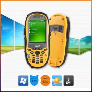
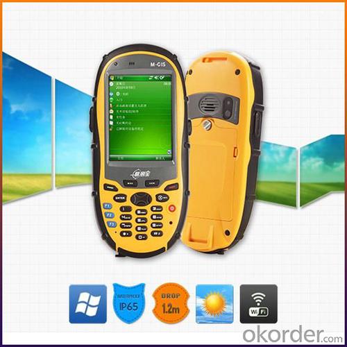
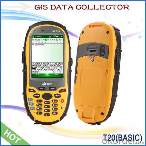
Key Features:
1. Fast GPS receiver with 50 channels, high sensitive and anti-interference antenna.
2. Optional mobile operation system: Windows Mobile6.1 or Mobile6.5 or Android 2.3, high compatibility.
3. 3.5G communication mode, Bluetooth, WIFI, multi-mode data transmission for whole T20 series, camera and microphone for multimedia data collection, RFID provides convenient conditions for asset management users.
4. 5 megapixel camera, automatic focus, adding geographic coordinate function for photos.
5. Double input modes: Touch screen and keyboard.
6. SDK support.
7. 3-proof design IP65, compact, portable and convenient.
Product Models:


Technology Specs:
GNSS performance | Channel | 50 channe,l L1 |
Antenna | High sensitive, anti-interference antenna | |
Real Time Accuracy | 3~5M | |
DGPS(RMS) | 1~3M(SBAS),<1m(RTCM Input) | |
System | Operation System | Microsoft Windows Mobile6.1 or Mobile6.5, or Android 2.3 |
CPU | 806MHz | |
Memory | 256MB RAM | |
Output | Max. 4Hz output | |
Equipment Character | Camera | 5 megapixel camera with autofocus, Max. resolution 2592*1944 pixel, supports photos and position coordinate collection. |
Keyboard | 10 digital keys, supports figure, English input, 9 system function keys, provides SDK, supports user-defined, 3 quick start keys, visible in night. | |
Microphone | Supports voice recording | |
Speaker | Built-in speaker | |
TF Memory Card | Standard 2G, Supports Up To 32G | |
Communication Function | Cellular Voice&Data(Optional) | HSDPA,3.5G/WCDMA/GPRS |
Bluetooth | 2.1+EDR | |
Wi-Fi | Supports 802.11b/g/n, wireless LAN | |
RFID (optional) | 13.56MHz RFID | |
USB port | MiniUSB2.0 | |
Series port | Supports Protocol RS232 | |
Physical | Display | 3.2”(diagonal ) touch screen |
Display Effect | 320*240 pixel, 260,000 colors | |
Waterproof | IP65 | |
Drop | Naturally 1.2 m drop over concrete | |
Working Temperature | -20°C ~ +60°C | |
Storage Temperature | -30°C ~ +70°C | |
Dimension | 165*78*28mm | |
Net Weight | 230g(including battery) | |
Packing | Packing Box Dimension | 205*135*85mm |
Gross Weight | 701g | |
Power Supply | Battery | 3100mAH rechargeable and replaceable Li-ion battery, 10H working time |
Languages | Operation System languages |
Chinese(Simplified) Chinese(HongKong), English, Spanish, French, German, Dutch, Italian, Russian (It is discussable to change the language provided the quantity is large) |
Field Software Languages | Chinese, English,Portuguese(Brazil),Spanish,Romanian, Swedish, Turkish,Polish, Arabic, Estonian, Finnish, French, German, Greek, Hebrew, Hungarian, Japanese, Korean, Latvian, Lithuanian, Norwegian, Pashto, Czech, Danish, Dutch |
Remarks:
1. Specifications subject to change without notice.
2. Accuracy and reliability depend on the quality of GPS signal and working environment.
3. Battery life time and charge cycles will vary with conditions and environment of use.
4. Software may vary depending on configuration.
5. Weight varies from configurations and optional accessories.
Application:
Utilities: Asset management, rapid response.
Local government: Asset management, issue reporting, emergency mangement.
Environmental management:Data collection.

Packing:

Delivery:

- Q: I would like to ask the GPS handset and GPS receiver (Surveying and mapping qualification application needs) is there a difference? If yes, what is the difference?
- 1. GPS is a geodetic instrument, with an accuracy of CM, generally for the millimeter,,Divided into (1) pure static type, such as the South Star of the North Star, the accuracy of mm, now the basic domestic,,(2) RTK, RTK can do is use, carrier phase measurement, the precision is cm level, RTK mobile station must have the control hand book, like television and remote similar, but now there are a lot of hand book can be used as handset2. The handset is generally rough field positioning equipment, navigation for mobile phone use, the general size, precision grade m, now can to about 20cm, and can be used for RTK mobile station use (need to access the base station) can reach cm level.Surveying and mapping qualification applications require geodetic measurement equipment, that is, 1.Now domestic GPS, such as the Haida, the south, China, etc. can be measured, not expensive
- Q: Is it accurate to measure highway mileage with GPS handheld
- Measuring mileage, since the unit has been upgraded to the inside, it is quite accurate oh
- Q: Handheld GPS locator measuring accuracy is about how many meters?
- The higher the accuracy, the higher the price. You can consult the Haida official website mobile MGIS mall
- Q: What is the difference between professional GPS handsets and mobile navigation?
- GPS is the most important positioning accuracy. Professional handheld machine with industrial design. First of all, if used outdoors, then fell, and so on are likely to water, and this thing is also very expensive, so the opportunity to have a high professional anti shock waterproof performance.
- Q: Mobile GPS can replace professional handheld GPS
- Ziphah measured Mu instrument, a key measurement area, the use of simple, SV-118, with high precision imported GPS module and antenna, accurate measurement, the block walk in a circle to measure the size and graphics trajectory, 550 yuan, USB charging, large capacity lithium battery, black and white screen to see the clear day for outdoor use.
- Q: What is GPS Mu meter ah, with the general said that the GPS measuring instrument what is the difference?
- The amount of words on the handheld GPS, Magellan can be both economic and affordable.
- Q: Verify the accuracy of the GPS device to buy back, the way is to use Android under the'gps state 'software, to test the accuracy of real-time single point positioning.1 with two sets of the same Android Tablet Computer (custom machine, type of bad) in the same position for receiving, find that the accuracy is the same (software, are 1-2 meters), but the position would be poor 10 meters or more. It's in the same place.The 2 one is the Android tablet computer, a mobile phone is HTC G10, also received together in the same position, find that the accuracy is not the same as (the latter 20 meters or so), but also may be about 10 meters position difference.The accuracy of this GPS device can reach 1-2 meters, while the same location in real-time single point positioning error of 10 meters, a reasonable explanation.
- 10 meters.To the world in 2013 a total of four global satellite navigation system, in addition to the United States has been in the mature GPS system and commercial operation, the Beidou system, China the European Galileo system, the Russian GLONASS system are still under construction. "The Galileo satellite navigation project" was first conceived by the 30 satellite GPS network to compete with the United States, the beginning of the design proposed in 2008 formally put into operation, and later postponed to 2014, the entire system is only 4 satellites in orbit (as of 2012), in fact it is mainly used to further verify the relevant design and the working system of the system design, after the official start of Galileo satellite will launch. Formal networking satellites are being prepared. China satellite navigation system management office senior engineer Yang Qiangwen introduction, to 2012, the "system" in orbit satellites are also only verify satellite.
- Q: How do I still stay in the GPS navigation, GPS monitoring of the primary idea? FiveBusiness services, thank you!Future business services
- 6 people travel and adventure7 personal communication terminal (with mobile phones, PDA, electronic map integration)8 time synchronization of electric power, post and telecommunication9 accurate timing of admission10 accurate frequency of admission
- Q: What do you need to test for GPS?
- 5.DGPS you know, differential GPS (DGPS) positioning accuracy is very high, some GPS equipment providers set up a DGPS transmitter in some areas, free of charge to its customers, if customers are buying GPS receivers with DGPS function. The DGPS transmitter is a fixed GPS receiver (in a 100km ~ 200km exploration scene in the radius setting) receive satellite signals, it knows exactly what is the exact time of transmitting satellite signal to the theory, and then compare it with the actual delivery time, then calculate the "difference", influence this is very close to the atmospheric refraction, it will send out the difference, usually with FM (FM) radio data transmission using subcarrier modulation signal in the baseband receiver, GPS and DGPS function can receive and use it more accurate positioning.
- Q: What is the difference between professional navigation and professional GPS navigator
- The same, but it is over. No practical significance.
1. Manufacturer Overview
| Location | Guangzhou, China |
| Year Established | 1999 |
| Annual Output Value | US$ 45.75 Million |
| Main Markets | Korea; Iran; Indonesia; Philippine; Poland; Italy; Brazil; South Africa; Russia |
| Company Certifications | FCC; CE |
2. Manufacturer Certificates
| a) Certification Name | |
| Range | |
| Reference | |
| Validity Period |
3. Manufacturer Capability
| a) Trade Capacity | |
| Nearest Port | Shenzhen; Guangzhou |
| Export Percentage | 8% |
| No.of Employees in Trade Department | 900 People |
| Language Spoken: | English; Chinese; Spanish; Arabic |
| b) Factory Information | |
| Factory Size: | Occupy 3000 square meters |
| No. of Production Lines | Above 5 |
| Contract Manufacturing | OEM Service Offered; Design Service Offered |
| Product Price Range | High; Average |
Send your message to us
GIS Data Collector
- Ref Price:
-
- Loading Port:
- China Main Port
- Payment Terms:
- TT or LC
- Min Order Qty:
- 10 set
- Supply Capability:
- 200 Sets Per Day set/month
OKorder Service Pledge
OKorder Financial Service
Similar products


Hot products


Hot Searches
Related keywords

