


Transparant Map Scale Compass DC35-2
- Ref Price:
-

- Loading Port:
- China Main Port
- Payment Terms:
- TT OR LC
- Min Order Qty:
- -
- Supply Capability:
- -
OKorder Service Pledge
OKorder Financial Service
You Might Also Like


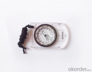
Model: DC35-2
Name: Professional map compass, ruler compass
Product Origin: China
Supply Ability: 10,000 pcs/month
Minimum Order: 50 pcs
MOQ for OEM package: 500pcs
Product Size: 86*60*10 (mm)
Features
1, professional usage: orientation, distance measuring, measuring slope, azimuth and pitching Angle measurement, drawing, a magnifying glass
2, high quality compass with neck rope, portable and rugged
3, ACRYLIC material, about 2mm thick
4, Damping Dial: to keep the stability of the pointer, more suitable for outdoor
environment.
5, Accuracy: accurate and clear, there were 360 degrees azimuth Angle, outer ring is 64-00 system, Liquid filled in the compass for reliable readings.
6, Magnifier function
- Q: Handheld GPS positioning, can be directly uploaded to the computer, and the computer has a scalable map to mark the upload point. The above system, now there are 20Such as the title, I want to achieve the final function: through the manual to a point, with a hand-held GPS locator will be recorded in the specific latitude and longitude, and sent to the network in real time, for my computer to mark these points on the map. If you can directly enter the site of some of the information, directly to the above is the bestIf you have the above equipment, please indicate the scientific name, and the specific application industry.Thanks.
- 13 support GPS satellite positioning function, the need to connect GPS satellite positioning hardware devices (USB GPS devices or Bluetooth GPS devices; tablet PC).14 support offline map pack custom download function, you can download the map anywhere in the world.
- Q: Handheld GPS need to put the phone card?
- Hello, now the general GPS are required to put the card! Thanks
- Q: GPS Mu meter which brand is good, handheld high-precision land area measuring instrument
- A German born mu can also recommend a good precision measuring instrument.Simple operation, the screen is large, a few buttonsBoot, and then look at the star almost, to find a field, start and then click on the end of a circle, out of the number ofElectricity can alsoPrecision mody... With a special RTK or not, but what is sure to measure a circleFlat measurement of quasi accurate, biased on what is almost, it can be accepted
- Q: My friend is in use, the difference is not big, professional handset (smart or Magellan bulky, but 3 case), but the price is expensive, but can not call and map is very rotten, endurance of 10 hours (dry battery) the mobile phone also has all the time. Know friends say, I mainly in the suburbs! Thanks
- Professional GPS is mainly used for acquisition, is not used for navigation; of course, some professional GPS can install third party software, the accuracy is higher than the phone, this is positive;Mobile navigation is only used for navigation, navigation, path analysis and navigation functions, not the acquisition of maps of the instrument.
- Q: Handheld GPS locator measuring accuracy is about how many meters?
- The higher the accuracy, the higher the price. You can consult the Haida official website mobile MGIS mall
- Q: Handheld GPS navigation is what? Where to buy handheld GPS navigation, how to select GPS navigation?
- Select the main consideration of the following issues on the line:1, GPS receiving capacity, in the interior, the streets can be measured on a few stars, while looking at the speed of the search star? If a place for 2 - 3 minutes accurate positioning can be used2, the map is the latest, often used to check those routes3, battery life is how long to ask4, accessories, such as support, car charge, the size of the memory card should be clearly presentedThe location of the purchase is usually in the car decoration department or the electronic mall or digital products store salesAffordable mall can look at the old brand, operating for many years, where I bought the electronic dog
- Q: Mountaineering to buy a professional GPS or Mountaineering Watch
- There is no need to buy too many devices. Now the phone is an essential tool, the phone has GPS,
- Q: Hand held GPS coordinate conversion method
- Two. To coordinate the coordinate data of the control points obtained provide technical support unit of Beijing Unistrong companies around the branch responsible person to calculate the coordinate transformation parameters conversion parameters, or to obtain their own conversion conversion software. After the conversion parameters are calculated by the prompt input handheld GPS. Only after such a setup, after all the soil in the region when the coordinates of the GPS read out the coordinates of the point for the Beijing 54 coordinates.
- Q: Verify the accuracy of the GPS device to buy back, the way is to use Android under the'gps state 'software, to test the accuracy of real-time single point positioning.1 with two sets of the same Android Tablet Computer (custom machine, type of bad) in the same position for receiving, find that the accuracy is the same (software, are 1-2 meters), but the position would be poor 10 meters or more. It's in the same place.The 2 one is the Android tablet computer, a mobile phone is HTC G10, also received together in the same position, find that the accuracy is not the same as (the latter 20 meters or so), but also may be about 10 meters position difference.The accuracy of this GPS device can reach 1-2 meters, while the same location in real-time single point positioning error of 10 meters, a reasonable explanation.
- 10 meters.To the world in 2013 a total of four global satellite navigation system, in addition to the United States has been in the mature GPS system and commercial operation, the Beidou system, China the European Galileo system, the Russian GLONASS system are still under construction. "The Galileo satellite navigation project" was first conceived by the 30 satellite GPS network to compete with the United States, the beginning of the design proposed in 2008 formally put into operation, and later postponed to 2014, the entire system is only 4 satellites in orbit (as of 2012), in fact it is mainly used to further verify the relevant design and the working system of the system design, after the official start of Galileo satellite will launch. Formal networking satellites are being prepared. China satellite navigation system management office senior engineer Yang Qiangwen introduction, to 2012, the "system" in orbit satellites are also only verify satellite.
- Q: My cell phone: HTC Hero 200Question type: Internet softwareMy work needs to locate, record, output, and input GPS coordinates. Track record measurement, coordinate transformation. So would you have a professional security software under the table, so go out with a mobile phone or a PAD, or N equipment back to survey the tired,
- SOSO map is good, I use this.Kelid navigation is also good.
Send your message to us
Transparant Map Scale Compass DC35-2
- Ref Price:
-
- Loading Port:
- China Main Port
- Payment Terms:
- TT OR LC
- Min Order Qty:
- -
- Supply Capability:
- -
OKorder Service Pledge
OKorder Financial Service
Similar products


Hot products


Hot Searches
Related keywords

