


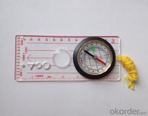
Transparant Map Scale Compass DC47-2
- Ref Price:
-

- Loading Port:
- China Main Port
- Payment Terms:
- TT OR LC
- Min Order Qty:
- -
- Supply Capability:
- -
OKorder Service Pledge
OKorder Financial Service
You Might Also Like


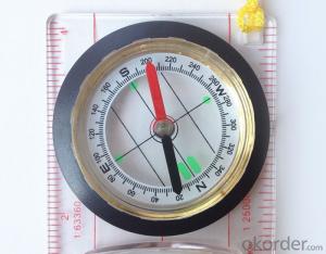
Model: DC47-2
Name: Professional map compass, ruler compass
Product Origin: China
Supply Ability: 10,000 pcs/month
Minimum Order: 50 pcs
MOQ for OEM package: 500pcs
Product Size: 115*55*11 (mm)
Features
1, professional usage: orientation, distance measuring, measuring slope, azimuth and pitching Angle measurement, drawing, a magnifying glass
2, high quality compass with neck rope, portable and rugged
3, ACRYLIC material, about 2mm thick
4, Damping Dial: to keep the stability of the pointer, more suitable for outdoor
environment.
5, Accuracy: accurate and clear, there were 360 degrees azimuth Angle, outer ring is 64-00 system, Liquid filled in the compass for reliable readings.
6, Magnifier function
- Q: Handheld GPS need to put the phone card?
- Travel GPS professional solutions:Put card. Will be equipped with a card at the time of purchase.
- Q: Can you buy a good handheld GPS in China? FiveTrouble master recommended several professional handheld GPS brand, in addition to handheld GPS can speed it? Thank you!!
- The main function is to use navigation as long as the navigation function can be used
- Q: Handheld GPS navigation is what? Where to buy handheld GPS navigation, how to select GPS navigation?
- Handheld GPS is mainly for GIS data acquisition, a lot of advanced GPS with PDA function, you can load navigation software for vehicle navigationBut the handheld GPS is mainly to do some engineering design, the main area can be measured, the location, and the boundary survey. GPS can do advanced vehicle navigation can also waypoint navigation, is a coordinate input to precise navigation to this position.Handheld GPS navigation is divided into 2 kinds, one is portable GPS navigation, one is used for surveying and mapping professional GPS handheld
- Q: What is the difference between the phone's GPS and professional handheld GPS features and differences?
- With more professional and more accurate positioning but are generally used dry batteries or rechargeable batteries not built-in rechargeable battery that is because handheld GPS users are mostly investigation or walk tourists convenient in use and emphasizes there is screen are generally of low power consumption for general color screen can only convey longitude and altitude mobile phone GPS is just a subsidiary function loading car navigation map
- Q: Handheld GPS brand rankings
- Set of SIBAO products awarded the Beijing independent innovation product identification certificate, satellite navigation and Engineering Excellence Award and other professional awards. At the time, location, navigation and other comprehensive applications, Unistrong successful implementation of hundreds of large projects, services in many national key projects, won the national honor.
- Q: Handheld GPS which brand is good
- Now GPS can also do handheld measurement accuracy, precision can usually reach decimeter level, the industry there are relatively well-known Huace, professional GPS measurement instrument, high precision of handheld GPS the good.
- Q: Handheld GPS and mobile phone GPS what is the difference?
- Different: antenna size, function, accuracy, protection level, and has been different in the application layer (handheld GPS support GPS compass navigation and map navigation and other more professional GPS applications);
- Q: Saying that we have a project in front of it is to do so, it is surprising that there are wood
- It is really unexpected, basically not, the accuracy is not enough!
- Q: Handheld GPS each brand has what difference; different price difference in where is the positioning accuracy is different or what function is not the same?What are the differences between the measurements and the cars?
- I was engaged in car GPS positioning, the first difference between different prices is the biggest cost of different module determines the price, this is the precise positioning of the key, but also the guarantee of product quality, rather than low-cost copycat version, as a kind of different price mobile phone, why Apple four generation sell so expensive but, only a few hundred to copycat.
- Q: What qualifications should a normal GPS locator have?
- You ask is handheld GPS, it is the manufacturer's qualification requirements or what. For example, business license, tax registration certificate, organization code certificate, vendor authorization, software copyright, precision test report, 3C certificate, ISO9001, industrial grade IP certificate and other relevant qualification certificates and documents
Send your message to us
Transparant Map Scale Compass DC47-2
- Ref Price:
-
- Loading Port:
- China Main Port
- Payment Terms:
- TT OR LC
- Min Order Qty:
- -
- Supply Capability:
- -
OKorder Service Pledge
OKorder Financial Service
Similar products


Hot products


Hot Searches
Related keywords

