


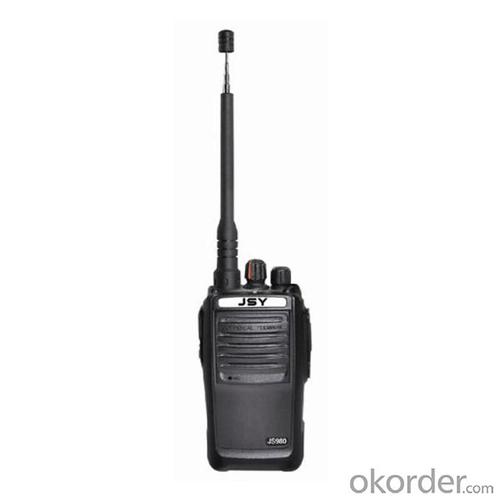
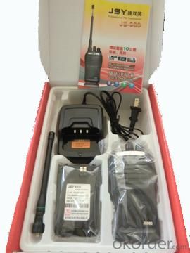

Professional Handheld Two Way Radio JS-980
- Ref Price:
-

- Loading Port:
- China Main Port
- Payment Terms:
- TT or LC
- Min Order Qty:
- 10 Sets set
- Supply Capability:
- 500 Sets/Week set/month
OKorder Service Pledge
OKorder Financial Service
You Might Also Like


Specifications of Professional Handheld Two Way Radio JS-980
General | |
Frequency Range | 400- 470MHz |
Channel Capacity | 16 |
Operated Voltage | 7.4V |
Battery Capacity | H-1500 MAh Li-ion |
Battery Life(5-5-90 duty cycle) | About 10 Hours |
Frequency Stability | ±2.5ppm |
Operated Temperature | ﹣20℃-﹢60℃ |
Antenna Impedance | 50Ω |
Dimensions | 127mmx61mmx36mm |
Transmitter | |
RF Power Output | 7W |
Modulation | F3E |
Spurious Emission | 65dB |
FM Noise | 45dB(W) /42dB (N) |
Audio Distortion | ≦5% |
Transmitting Current | ≦1000mA |
Receiver | |
Sensitivity (12dB SINAD) | ≧0.20μV |
Intermodulation | ≧65dB |
Adjacent Channel Selectivity | ≧60dB |
Spurious Response | ≧60dB |
FM Noise | 45dB(W) /42dB (N) |
Audio Distortion | ≦5% |
Accessory | |
Battery/Antenna/Charger/Belt Clip | |
Applications of Professional Handheld Two Way Radio JS-980


Certificates of Professional Handheld Two Way Radio JS-980

Wokshop of Professional Handheld Two Way Radio JS-980

Testing Equipments of Professional Handheld Two Way Radio JS-980

Shipment of Professional Handheld Two Way Radio JS-980

- Q: GPS Mu meter which brand is good, handheld high-precision land area measuring instrument
- Simple operation, the screen is large, a few buttonsBoot, and then look at the star almost, to find a field, start and then click on the end of a circle, out of the number ofElectricity can alsoPrecision mody... With a special RTK or not, but what is sure to measure a circleFlat measurement of quasi accurate, biased on what is almost, it can be accepted
- Q: Can a handheld navigator connect a cell phone? Thank you
- Open the phone hotspot WiFi, handheld navigator connected to this wifi.
- Q: Handheld GPS which brand is good
- Now GPS can also do handheld measurement accuracy, precision can usually reach decimeter level, the industry there are relatively well-known Huace, professional GPS measurement instrument, high precision of handheld GPS the good.
- Q: Welcome to make comments on the existing GPS tour pal what shortcomings to answer the more detailed the better
- Fifth elements: the terrain map is the main project of outdoor sports climbing, mountain climbing is very exhausting, we usually do a plan will be completed on schedule, a good plan should be to our destination in the manual run out before. And if you want to do this, it must be on the road difficult to have a correct anticipation. But this time, with the terrain map GPS can come in handy, the mountains and the altitude of the understanding, we need to know about these sections spend much time and energy. And the general GPS map, is unable to meet the needs. So we'd better buy a map with contour terrain data of professional grade GPS, make your own outdoor journey do in our hands.
- Q: I am a handheld GPS precision is low, how to use to be able to improve certain accuracy
- If you can join the CORS network, the accuracy of decimeter to centimeter level.
- Q: Fuxin coordinates with the mapping of the seven parameters are what ah there is no professional knowledge to tell my brother I need to fill the gps... Thanks.
- Handheld GPS has not been used, you can find three known control points, try to solve.
- Q: I just bought a handheld GPS Magellan No. 1, showing the latitude and longitude coordinates, I want to set the geodetic coordinates of latitude and longitude, do not know where to set, I would like to ask you, how to set, there is a better picture shows the best, thank you so much.Magellan GPS 210 is not 2000 shy
- 1 position: [format setting unit - "[] position display format is set to User UTM Grid, and enter the relevant parameters, such as the 3 degree or 6 degree with the area with the central meridian projection, the ratio was 1, that deviation is 500000m, north-south deviation is 0.2 map reference setting: [[map] - unit "benchmark is set to User, and input the DX, DY, DZ, DA, DF parameters, usually DX, DY, DZ vary from region to region, so need to know the high level control points to solve, solving methods are as follows:The handheld GPS is placed in the control point field buried pile, were measured, and then hand coordinate coordinates and the known control points of the GPS measurements obtained for the poor, can be obtained by local coordinates and elevation deviation value: DX, DY, DZ.
- Q: Handheld GPS, the measurement of arable land, fixed point and circle test, which is more accurate,
- If the measurement point is only the case, the dynamic GPS is now the general error can be guaranteed within 3cm, the total station can be guaranteed to the millimeter.
- Q: What qualifications should a normal GPS locator have?
- You ask is handheld GPS, it is the manufacturer's qualification requirements or what. For example, business license, tax registration certificate, organization code certificate, vendor authorization, software copyright, precision test report, 3C certificate, ISO9001, industrial grade IP certificate and other relevant qualification certificates and documents
- Q: What is the difference between professional navigation and professional GPS navigator
- The same, but it is over. No practical significance.
Send your message to us
Professional Handheld Two Way Radio JS-980
- Ref Price:
-
- Loading Port:
- China Main Port
- Payment Terms:
- TT or LC
- Min Order Qty:
- 10 Sets set
- Supply Capability:
- 500 Sets/Week set/month
OKorder Service Pledge
OKorder Financial Service
Similar products
Hot products


Hot Searches
Related keywords

