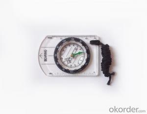
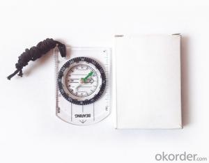
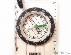
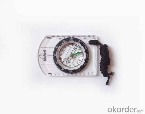


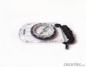
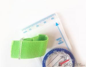
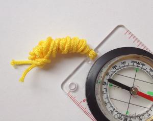
Professional Map or Ruler CompassDC35 for Surveying
- Ref Price:
-

- Loading Port:
- Tianjin
- Payment Terms:
- TT OR LC
- Min Order Qty:
- 20 pc
- Supply Capability:
- 10000 pc/month
OKorder Service Pledge
OKorder Financial Service
You Might Also Like


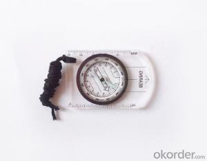


Model: DC35-1B
Name: Professional map compass, ruler compass
Product Origin: China
Supply Ability: 10,000 pcs/month
Minimum Order: 50 pcs
MOQ for OEM package: 500pcs
Product Size: 70*48*9 (mm)
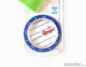
Features of DC35-B
1, professional usage: orientation, distance measuring, measuring slope, azimuth and pitching Angle measurement, drawing, a magnifying glass
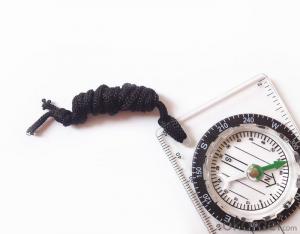
2, high quality compass with neck rope, portable and rugged
3, ACRYLIC material, about 2mm thick
4, Damping Dial: to keep the stability of the pointer, more suitable for outdoor environment.
5, Accuracy: accurate and clear, there were 360 degrees azimuth Angle, outer ring is 64-00 system, Liquid filled in the compass for reliable readings.
6, Magnifier function
5,ruler compass,
6,for map measure and drawing
7,one meter neck rope,
8,Liquid filled in the compass for reliable readings,
9, magnifier function.
- Q: I would like to ask the GPS handset and GPS receiver (Surveying and mapping qualification application needs) is there a difference? If yes, what is the difference?
- 1. GPS is a geodetic instrument, with an accuracy of CM, generally for the millimeter,,Divided into (1) pure static type, such as the South Star of the North Star, the accuracy of mm, now the basic domestic,,(2) RTK, RTK can do is use, carrier phase measurement, the precision is cm level, RTK mobile station must have the control hand book, like television and remote similar, but now there are a lot of hand book can be used as handset2. The handset is generally rough field positioning equipment, navigation for mobile phone use, the general size, precision grade m, now can to about 20cm, and can be used for RTK mobile station use (need to access the base station) can reach cm level.Surveying and mapping qualification applications require geodetic measurement equipment, that is, 1.Now domestic GPS, such as the Haida, the south, China, etc. can be measured, not expensive
- Q: Handheld GPS how to achieve decimeter
- Hello A GPS is not up to the requirements of the class, if no one can buy that expensive submeter GPS, currently on the market with the best precision is GPS, is Derek GARMIN this year a new eTrex 10, 20 and 30, the three can be reached within 3 meters accuracy, you can look at
- Q: Can you buy a good handheld GPS in China? FiveTrouble master recommended several professional handheld GPS brand, in addition to handheld GPS can speed it? Thank you!!
- If it is used, there is no difference.
- Q: My friend is in use, the difference is not big, professional handset (smart or Magellan bulky, but 3 case), but the price is expensive, but can not call and map is very rotten, endurance of 10 hours (dry battery) the mobile phone also has all the time. Know friends say, I mainly in the suburbs! Thanks
- Design ideas and the use of different objectsThe handheld is designed for military, mapping, mining, agriculture, outdoor sports (hiking, hiking, orienteering, cycling, water sports, paragliding, etc.).Cell phone navigation is designed to drive a car in the city, built-in interest points are mostly concentrated in the city.
- Q: Want to buy handheld GPS in Hongkong, I would like to ask what brand is better, the specific model? Where to buy? How much is the price? In the mainland can be used? More questions, thank you!
- I doubt this question will be answered by the people of Hongkong?Handheld GPS do best is GARMIN, Taiwan and the mainland are agents. It's all the same.
- Q: Handheld GPS which brand is good
- Now GPS can also do handheld measurement accuracy, precision can usually reach decimeter level, the industry there are relatively well-known Huace, professional GPS measurement instrument, high precision of handheld GPS the good.
- Q: What is the difference between a hand-held GPS and a car's onboard navigator
- As the first floor of a friend to answer the same, the general application of hand-held devices in land surveying, mountain climbing and other precise positioning when measuring the use of. Long standby time, three good performance. Easy to carry. A single charge can be used for a long time (depending on the machine). Although navigation, but the map is not detailed. At the same time, there is an opportunity to have latitude, latitude and other information.The car navigation is designed for users to drive out, in the field when not familiar with the road, ah, not familiar with the surrounding buildings, such as parking, hospitals, restaurants, gas stations. Used. Map details. But does not provide information such as latitude accuracy. No elevation.Look what you're doing. There is also a mobile phone navigation function.If you are purely for entertainment, then choose the phone.If you want to navigate in the car, select the vehicle navigation.If you are a very professional outdoor sports enthusiasts on the choice of handheld.
- Q: Saying that we have a project in front of it is to do so, it is surprising that there are wood
- Hello friends, so, do 1:2000 topographic mapping with a handheld GPS is obviously not reality, after all, the handheld GPS precision is, however, now we are in the handheld equipment is no GPS, in fact, in the absence of the base station is a handheld GPS, receiving SBAS difference can reach sub meter level, but if a base station or receive CROS network differential signal will be RTK mobile station,
- Q: Magellan GPS handheld why so many people choose not to say that the map is not good
- Select the right access to GPS oh it has a contact information users
- Q: How to upgrade handheld navigator
- Some 4S shop can;Read the instructions, there are generally USB mouth, then you can upgrade the computer practice;There is a memory card, then you can remove the plug on the computer upgrade;Or get the computer city to see it.
Send your message to us
Professional Map or Ruler CompassDC35 for Surveying
- Ref Price:
-
- Loading Port:
- Tianjin
- Payment Terms:
- TT OR LC
- Min Order Qty:
- 20 pc
- Supply Capability:
- 10000 pc/month
OKorder Service Pledge
OKorder Financial Service
Similar products

Hot products


Hot Searches

