


Professional Mapping Mini Compass with Scale
- Ref Price:
-

- Loading Port:
- Tianjin
- Payment Terms:
- TT OR LC
- Min Order Qty:
- 50 pc
- Supply Capability:
- 10000 pc/month
OKorder Service Pledge
OKorder Financial Service
You Might Also Like


Structure of Mapping Compass Discription
Model: DC35-1A
Name: Professional map compass, ruler compass
Product Origin: China
Supply Ability: 10,000 pcs/month
Minimum Order: 50 pcs
MOQ for OEM package: 500pcs
Main Features of Mapping Compass
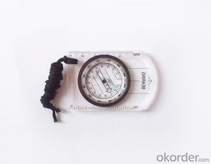
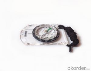
1, professional usage: orientation, distance measuring, measuring slope, azimuth and pitching Angle measurement, drawing, a magnifying glass
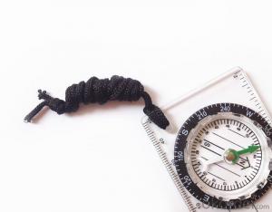
2, high quality compass with neck rope, portable and rugged
3, ACRYLIC material, about 2mm thick
4, Damping Dial: to keep the stability of the pointer, more suitable for outdoor environment.
5, Accuracy: accurate and clear, there were 360 degrees azimuth Angle, outer ring is 64-00 system, Liquid filled in the compass for reliable readings.
6, Magnifier function
7,one meter neck rope,
8,Liquid filled in the compass for reliable readings,
9, magnifier function.
10,night vision map compass
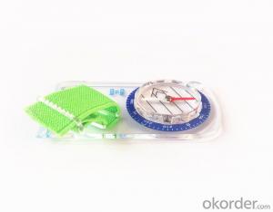
Mapping Compass Images


Map Scale Compass Specification:
Product Size: 86*60*10 (mm)
Color: OEM
FAQ of Map Scale Compass:
1,What is the warranty for this product?
3 months after receiving the device.
2,How long could we get the goods?
Within one week after payment, the product will be sent out.
3,Do you have service centers abroad?
No.The service centers are in China at present.
- Q: I would like to ask the GPS handset and GPS receiver (Surveying and mapping qualification application needs) is there a difference? If yes, what is the difference?
- This is the case, GPS handheld refers to a thin hand, while the GPS receiver refers to the RTK host, equivalent to the base station in our industry said. The general application of Surveying and mapping qualifications are required for this application, referred to as RTK (1+1) set, level, theodolite, total station, walkie talkie, technical personnel.... And so on, are essential equipment.
- Q: Is it accurate to measure highway mileage with GPS handheld
- Can only say that the handheld GPS measurement of highway mileage can be a reference, if you want to measure the accuracy or sub meter level or professional measuring tools better
- Q: Handheld GPS navigation is what? Where to buy handheld GPS navigation, how to select GPS navigation?
- Handheld GPS navigator, also known as portable navigator, but also divided into 2 kinds, one is the ordinary PND navigator, you can go to Zhongguancun, the major appliance stores to buy, and the other is the mobile navigation, GPS smart phone is installed in the GPS navigation software can be,The navigator is composed of 2 parts: hardware and navigation software. The navigator on the market is about RMB 600. The brand of Kelid navigation software is usedGPS is a portable handheld navigation navigation products, the market is now very much, most car navigation can be used, the Gps signal is still free to receive satellite signals in the United States, you only need to charge it, map to the sellers in general can be upgraded.
- Q: I bought the way k20s, this handheld GPS how
- Choi way handheld GPS feel that you can also be in the last year, the Zhengzhou Bureau of Surveying and mapping seems to be called the wide Han instrument that home to buy, so there is no problem with it, the price is not expensive.
- Q: GPS handheld function to measure it?
- If the construction survey is certainly not the case, the control measurement is possible
- Q: How to use the handheld GPS whole watershed investigation
- Some people think that the use of critical state to solve the most value should be cautious, we must first distinguish the relationship between the two states
- Q: What do you need to test for GPS?
- As a high-tech product, GPS has a very complex technical parameters. However, as people's living standards improved rapidly, more and more ordinary people began to pay attention to the positioning and navigation tools originated from the military. Because the convenience it brings is unprecedented. In order to let everyone out of all the technical parameters of GPS receiver, no longer confused at the time of purchase, the author selected six of the most important technical indicators, one by one to explain to you. 1 parallel channels on the market most of the GPS receiver is a 8 channel, 12 channel, the 16 channel, which allows them to continuously track the information of each satellite. Some GPS devices only have 2 to 5 parallel channel receiving satellite signals, because the average of 8 satellites are visible, which means that the GPS receiver must visit each of the satellites in order to obtain information about each satellite. All of our products are in Shenzhen channel 16 channel, multi-channel parallel GPS receiver, including the advantages of rapid cold start and initialization of satellite information, but also in the forest area can have a better reception. General 12 channel receiver does not require an external antenna, unless you are in a bad environment conditions such as closed space, such as the cabin, the car. 2 the sensitivity of the GPS satellite signal to the ground has been very weak, as well as ground wireless communication clutter interference. The lowest traceable signal strength of the GPS receiver determines how much useful signal is received. A GPS receiver with a lower minimum tracking signal strength has a higher sensitivity, and can receive more available satellites under bad conditions
- Q: Magellan GPS handheld why so many people choose not to say that the map is not good
- Magellan navigation and positioning company with Taiwan Jia Ming Company as the world's leading outdoor handheld GPS, its product features have their own advantages. General Magellan price will be slightly higher, Derek source may be more, but in recent years, the 2 brands will be on a par with slowly, Magellan with the national topographic map, a detailed map of the vehicle with the navigation package, Derek product price has been lowered. If the old section of the handheld GPS feel Magellan's design is more fashionable, the new Magellan with better Ming products have their own characteristics, mainly to see their own habits and tastes.
- Q: How to upgrade handheld navigator
- Hello to the brand's official website to download the latest map copy to memory card on the lineI wish you a pleasant car!
- Q: What qualifications should a normal GPS locator have?
- Look at his company's business license is what's on the line, if the manufacturer has the most basic 3C proved, and some such as system certification or proof of what the explosion proof CEPREI
Send your message to us
Professional Mapping Mini Compass with Scale
- Ref Price:
-
- Loading Port:
- Tianjin
- Payment Terms:
- TT OR LC
- Min Order Qty:
- 50 pc
- Supply Capability:
- 10000 pc/month
OKorder Service Pledge
OKorder Financial Service
Similar products


Hot products


Hot Searches
Related keywords

