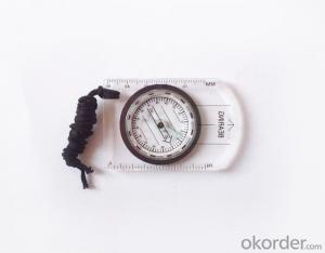
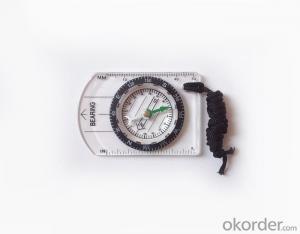
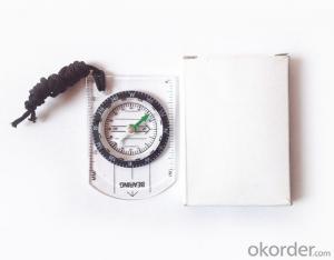
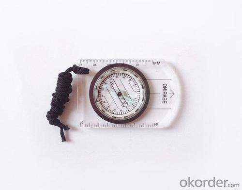
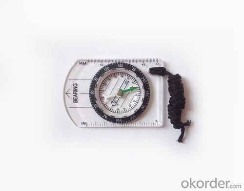

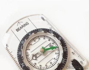
Plastic Map or Ruler CompassDC35 for Surveying
- Ref Price:
-

- Loading Port:
- Tianjin
- Payment Terms:
- TT OR LC
- Min Order Qty:
- 20 pc
- Supply Capability:
- 10000 pc/month
OKorder Service Pledge
OKorder Financial Service
You Might Also Like


Model: DC35-1B
Name: Professional map compass, ruler compass
Product Origin: China
Supply Ability: 10,000 pcs/month
Minimum Order: 50 pcs
MOQ for OEM package: 500pcs
Product Size: 70*48*9 (mm)
Features of DC35-B
1, professional usage: orientation, distance measuring, measuring slope, azimuth and pitching Angle measurement, drawing, a magnifying glass
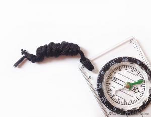
2, high quality compass with neck rope, portable and rugged
3, ACRYLIC material, about 2mm thick
4, Damping Dial: to keep the stability of the pointer, more suitable for outdoor environment.
5, Accuracy: accurate and clear, there were 360 degrees azimuth Angle, outer ring is 64-00 system, Liquid filled in the compass for reliable readings.
6, Magnifier function
5,ruler compass,
6,for map measure and drawing
7,one meter neck rope,
8,Liquid filled in the compass for reliable readings,
9, magnifier function.
- Q: I would like to ask the GPS handset and GPS receiver (Surveying and mapping qualification application needs) is there a difference? If yes, what is the difference?
- This is the case, GPS handheld refers to a thin hand, while the GPS receiver refers to the RTK host, equivalent to the base station in our industry said. The general application of Surveying and mapping qualifications are required for this application, referred to as RTK (1+1) set, level, theodolite, total station, walkie talkie, technical personnel.... And so on, are essential equipment.
- Q: Handheld GPS need to put the phone card?
- Hello, now the general GPS are required to put the card! Thanks
- Q: GPS Mu meter which brand is good, handheld high-precision land area measuring instrument
- A German born mu can also recommend a good precision measuring instrument.
- Q: Is it accurate to measure highway mileage with GPS handheld
- Can only say that the handheld GPS measurement of highway mileage can be a reference, if you want to measure the accuracy or sub meter level or professional measuring tools better
- Q: Seeking the similarities and differences between RTK and GPS
- RTK full name is GPS-RTK real-time dynamic distribution, which you know.
- Q: Hand held GPS coordinate conversion method
- Two. To coordinate the coordinate data of the control points obtained provide technical support unit of Beijing Unistrong companies around the branch responsible person to calculate the coordinate transformation parameters conversion parameters, or to obtain their own conversion conversion software. After the conversion parameters are calculated by the prompt input handheld GPS. Only after such a setup, after all the soil in the region when the coordinates of the GPS read out the coordinates of the point for the Beijing 54 coordinates.
- Q: Welcome to make comments on the existing GPS tour pal what shortcomings to answer the more detailed the better
- The first three factors: ability as a good tour pal, sun and rain fearless tramp over mountains and through ravines Rulvpingdi, GPS, his nature can not be weak, small knock a small touch can not have temper, off or out in the water dirty, also to be able to continue the work. So the waterproof / earthquake / dust and other indicators become the primary consideration factors GPS these are the protective ability of vehicle GPS, most of them do not have, and some professional GPS design, there will be more conducive to the harsh environment, such as some of the products designed to be capable of floating after falling into the water. The outdoor need to step back. What is it, if you can not do to prevent flooding, then rain proof ability is the minimum requirement.
- Q: How to use the handheld GPS whole watershed investigation
- Therefore, it is an important method to solve the maximum value in physics by solving the maximum and minimum values of the physical quantity by the critical state.
- Q: How to hand GPS eTrex H data to the computer
- "Shaanxi skmax navigation information Limited" GARMIN proxy (GARMIN official website can be found), contact (Xiao Hou) the hope can help to you, if you do not understand what we see on the Internet, may at any time, contact us!
- Q: Handheld GPS purchaseHandheld GPS navigator!Is mainly used for tourism, I said is not a mobile phone, is a more professional handheld GPS navigator for travel outside! Handheld GPS navigator can voice navigation?
- Many outdoor enthusiasts are used to this, hiking, cycling and other applications are relatively wide, is an American brand, Mr Zelen back to U.S. Army GPS, and as Ma Ying-Jeou ring when riding on the handlebars also put a good 60CSX. the two brands in the nature, the price is more expensive, are in more than 2000, but the best is to the store to buy. If only for tourism, generally hundreds of pieces of GPS will be enough, go to computer city to see, must be sold, or go to your city in the outdoor store to see.
Send your message to us
Plastic Map or Ruler CompassDC35 for Surveying
- Ref Price:
-
- Loading Port:
- Tianjin
- Payment Terms:
- TT OR LC
- Min Order Qty:
- 20 pc
- Supply Capability:
- 10000 pc/month
OKorder Service Pledge
OKorder Financial Service
Similar products

Hot products


Hot Searches

