


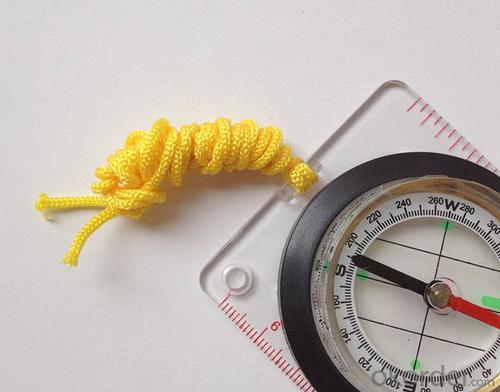


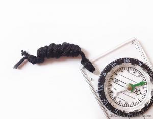
Professional Mapor Ruler Mini-Compass DC35-1 for Surveying
- Ref Price:
-

- Loading Port:
- Tianjin
- Payment Terms:
- TT OR LC
- Min Order Qty:
- 20 pc
- Supply Capability:
- 10000 pc/month
OKorder Service Pledge
OKorder Financial Service
You Might Also Like


Model: DC35-1
Name: Professional map compass, ruler compass
Product Origin: China
Supply Ability: 10,000 pcs/month
Minimum Order: 20 pcs
MOQ for OEM package: 500pcs
Product Size: 86*60*10 (mm)
Features of DC35-1
1, professional usage: orientation, distance measuring, measuring slope, azimuth and pitching Angle measurement, drawing, a magnifying glass
2, high quality compass with neck rope, portable and rugged
3, ACRYLIC material, about 2mm thick
4, Damping Dial: to keep the stability of the pointer, more suitable for outdoor environment.
5, Accuracy: accurate and clear, there were 360 degrees azimuth Angle, outer ring is 64-00 system, Liquid filled in the compass for reliable readings.
6, Magnifier function
5,ruler compass,
6,for map measure and drawing
7,one meter neck rope,
8,Liquid filled in the compass for reliable readings,
9, magnifier function.
- Q: What factors affect the handheld GPS receive signal?
- The hand-held GPS is generally accepted the satellite signal, a sheltered place will affect the signal delivery in different range of handset with method, sometimes, because of the incorrect operation, the human body is one of the obstacles
- Q: Highway measurement with GPS I do not know which of the base station settings and mobile station settings I are very vague, to the instrument to build a coordinate system how to build the relevant issues to me
- If you are a GPS base station location and measurement of road staff recommend that you use the professional version of the GPS version of the great error because you said is also a way of positioning is not accurate the coordinate system should also use professional equipment and operating personnel want to help you
- Q: Handheld GPS positioning, can be directly uploaded to the computer, and the computer has a scalable map to mark the upload point. The above system, now there are 20Such as the title, I want to achieve the final function: through the manual to a point, with a hand-held GPS locator will be recorded in the specific latitude and longitude, and sent to the network in real time, for my computer to mark these points on the map. If you can directly enter the site of some of the information, directly to the above is the bestIf you have the above equipment, please indicate the scientific name, and the specific application industry.Thanks.
- 10 classification layer management, you can hide / show layer.11 support batch import export data.12 support for drawing straight lines, curves and any line segments, can change the color and width.
- Q: How to set the handheld GPS related parameters and coordinate conversion parameters throughout the country
- Two. To coordinate the coordinate data of the control points obtained provide technical support unit of Beijing Unistrong companies around the branch responsible person to calculate the coordinate transformation parameters conversion parameters, or to obtain their own conversion conversion software. After the conversion parameters are calculated by the prompt input handheld GPS. Only after such a setup, after all the soil in the region when the coordinates of the GPS read out the coordinates of the point for the Beijing 54 coordinates.
- Q: Seeking the similarities and differences between RTK and GPS
- RTK full name is GPS-RTK real-time dynamic distribution, which you know.
- Q: What is the difference between industrial GPS handset and mobile navigation
- 3, professional handheld machine with industrial design. First of all, if used outdoors, then fell, and so on are likely to water, and this thing is also very expensive, so the opportunity to have a high professional anti shock waterproof performance.4, different screen design. If you look carefully, you can see in the outdoor light, mobile phone can not see the contents of the screen, while the professional handset is not the same, can see clearly in bright light, does not affect the work of foreign trade operations.
- Q: Mountaineering to buy a professional GPS or Mountaineering Watch
- Can be downloaded in general maps, satellite maps, and even contour maps, which features far more than handheld GPS or mountain climbing watches, you can better meet the needs of mountaineering.
- Q: Handheld GPS brand rankings
- Set of SIBAO products awarded the Beijing independent innovation product identification certificate, satellite navigation and Engineering Excellence Award and other professional awards. At the time, location, navigation and other comprehensive applications, Unistrong successful implementation of hundreds of large projects, services in many national key projects, won the national honor.
- Q: Magellan GPS handheld why so many people choose not to say that the map is not good
- Each brand has its own unique, if you only care about a map, then you think of the handheld too one-sided
- Q: What is the difference between professional navigation and professional GPS navigator
- 3 map software is accurate, you can identify the road on the viaduct, and you can tip up and down viaduct."This should be no problem currently on the market of the navigation software is mainly three: Skywalker, Kai Lide, cityonmap. Three navigation software has its own advantages and disadvantages. I personally feel that the person with Skywalker more, some car navigation systems (non open operating system) OEM software with Kay more than cityonmap map Skywalker is better but the interface is not good.4 mobile phone PDA load or other independent GPS devices can be.
Send your message to us
Professional Mapor Ruler Mini-Compass DC35-1 for Surveying
- Ref Price:
-
- Loading Port:
- Tianjin
- Payment Terms:
- TT OR LC
- Min Order Qty:
- 20 pc
- Supply Capability:
- 10000 pc/month
OKorder Service Pledge
OKorder Financial Service
Similar products


Hot products


Hot Searches

