
GIS K100
- Ref Price:
-

- Loading Port:
- China Main Port
- Payment Terms:
- TT OR LC
- Min Order Qty:
- -
- Supply Capability:
- -
OKorder Service Pledge
OKorder Financial Service
You Might Also Like


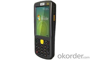
PJK-100 is based on WINDOWS MOBILE6.5 operating system, and it has high-resolution 3.5-inch 480X320 pixel touch screen, with wireless LAN and WAN 2.75G Netcom Communications and data transfer, support for GPS, 320 million auto-focus camera and video, support one, two dimensional scanning laser or image reading, support 13.56Mhz RFID reader, Bluetooth 2.0 short distance data transmission.
PJK-100 is an ideal, cost-performance ratio mobile GIS mapping solutions, in addition to the application of highly integrated functions, it is in strict accordance with industry standard IP54 package designed to meet the concrete floor 1.2 m drop test. And is equipped with a safety 3400mAh lithium polymer battery, to meet the equipment at full capacity 12 hours work!
1, the overall requirements
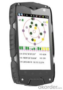
* 480x320 touch screen, 320 million camera, GPS
* Support for a two-dimensional scanning laser or image reading
* Support wifi, wide area network, RFID, Bluetooth, USB transfer
* 12 hours of continuous work, 30 days standby
2, the physical parameters
* Size: 155 mm (length) x 70 mm (W) x 26mm (thick)
* Weight (with standard battery): Standard battery, 265 g
* Display: 3.5 inch, HVGA (480X320) TFT high-brightness, touch screen
* Touch Panel: Glass analog resistive touch screen
* Backlight: LED backlight
* Main battery: 3.7V 3400mAH Li-polymer rechargeable battery smart
* Battery performance: full load of work for 12 hours, 300 hours standby
* Expansion Slots: Mini SD cards up to 32G
* Tip: Vibrating alert / LED prompts / Audio Tips
* Keyboard: side button + power button + the front of 30 keys keyboard
* Audio: Built-in microphone / MiniUSB headphone connector
3, the working environment
* Operating temperature: -30 ℃ ~ 50 ℃
* Storage temperature: -40 ℃ ~ 60 ℃
* Humidity: 5 ~ 95% (no condensation)
* Drop Specifications: multiple 1.2m (4ft.) a drop of cement concrete floor
* Seal standard: IP54
* Electrostatic Discharge: + /-15kV air discharge, + /-8kV direct discharge
4, the performance parameters
* CPU: ARM architecture Hisilicon 520MHZ
* Operating System: Microsoft Windows Mobile 6.5 Professional
* Memory: 256MB Flash ROM + 128MB SDRAM
* Interface: Mini USB interface / charge cradle
* Bluetooth: Bluetooth 2.0 + EDR
5, the network connection
* Wireless voice communication: 900/1800MHZ GSM
* Wireless Wide Area Networks: GPRS / EDGE
* Wireless LAN: WI-FI 802.11b / g
* GPS: with AGPS function Srif Star III navigation chip
* Camera: 320 mega pixel auto focus with LED fill light
6, data collection specifications
* Bar code: one-dimensional laser imaging, two-dimensional image scanner
* RFID 13.56MHZ, compatible with 14443/15693 protocol
7, one-dimensional laser scanner
* Optical resolution: greater than or equal 4mil
* Scan Depth: 3.81 cm -60.98 cm
* Scan angle: 47 ° ± 3 ° (standard)
* Scan speed: 102 ± 12 times per second (bi)
8, two graphics scanner
* Optical resolution: greater than or equal 3mil
* Scan angle: all the
* Scan speed: 300 times
9, GPS parameters
* 12-channel, L1 frequency C / A code, 1Hz update frequency; first fix time of 30 seconds (typical)
* 1 ~ 3 m accuracy in real time or post-processing, support for WAAS, EGNOS, MSAS wide area differential systems
* NMEA-0183 and SiRF protocol
10, optional software
PJK-100 is based on Microsoft Windows Mobile 6.5 operating system, provides an open platform to support third-party software, As a leader in the field of GIS, it can enable users to install third-party GIS software. Such as ESRI's ArcPad software.
Key Features:
Real- time meter accuracy
Integrated communications
Long life battry for professional
cost-effective mobile GIS mapping solutions
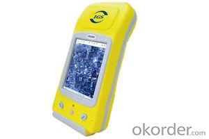
IGS-100 is based on Windows mobile 6.5 operating system, and it has high-resolution 3.5-inch 480X320 pixel touch screen, with wireless LAN and WAN 2.75G Netcom Communications and data transfer, support for GPS, 320 million auto-focus camera and video, support one, two dimensional scanning laser or image reading, support 13.56Mhz RFID reader, Bluetooth 2.0 short distance data transmission.
IGS-100 is an ideal, cost-effective mobile GIS mapping solutions, in addition to the application of highly integrated functions, it is in strict accordance with industry standard IP54 package designed to meet the concrete floor 1.2 m drop test. And is equipped with a safety 3400mAh lithium polymer battery, to meet the equipment at full capacity 12 hours work!
- Q: My friend is in use, the difference is not big, professional handset (smart or Magellan bulky, but 3 case), but the price is expensive, but can not call and map is very rotten, endurance of 10 hours (dry battery) the mobile phone also has all the time. Know friends say, I mainly in the suburbs! Thanks
- Design ideas and the use of different objectsThe handheld is designed for military, mapping, mining, agriculture, outdoor sports (hiking, hiking, orienteering, cycling, water sports, paragliding, etc.).Cell phone navigation is designed to drive a car in the city, built-in interest points are mostly concentrated in the city.
- Q: Is it accurate to measure highway mileage with GPS handheld
- Can only say that the handheld GPS measurement of highway mileage can be a reference, if you want to measure the accuracy or sub meter level or professional measuring tools better
- Q: I am ready to go to the field to go to college, but I do not know how to buy a handheld GPS, I hope you recommend. The most important thing is easy to carry.
- Younger brother, buy a smart phone, ranging from several hundred dollars to several thousand dollars, as long as the GPS module on the line, understand it?I'm not talking about it, as long as the smart phone with GPS module, you can use when GPS, can be used to drive, you can certainly use a walk. Even if there is no GPS die fast, with a cell phone signal can be positioned, but not too accurate. Hundreds of meters.In addition, you go to college, do not use smart phones, students are not afraid of jokes? Buy a Android system on the machine line. Cheap on a few hundred dollars.You say you take a hand-held machine, and then take a cell phone to go out, trouble is not trouble?
- Q: How to set the handheld GPS related parameters and coordinate conversion parameters throughout the country
- Two. To coordinate the coordinate data of the control points obtained provide technical support unit of Beijing Unistrong companies around the branch responsible person to calculate the coordinate transformation parameters conversion parameters, or to obtain their own conversion conversion software. After the conversion parameters are calculated by the prompt input handheld GPS. Only after such a setup, after all the soil in the region when the coordinates of the GPS read out the coordinates of the point for the Beijing 54 coordinates.
- Q: Mountaineering to buy a professional GPS or Mountaineering Watch
- Can be downloaded in general maps, satellite maps, and even contour maps, which features far more than handheld GPS or mountain climbing watches, you can better meet the needs of mountaineering.
- Q: Jia Ming etre20 handheld GPS good
- Jia Ming eTrex 20 has a microSD card slot and 1.7GB built-in memory space eTrex 20 allows you to store more user acquisition information, in addition to the map expansion slot, you can load the map of the global area of Garmin.
- Q: Professional handheld GPS GARMIN (DR) how to use
- Would like to use the function of handheld GPS purposes, the measurement of soil area, linear navigation, auxiliary fishing waypoint navigation point information, traffic data display, etc.
- Q: What is GPS Mu meter ah, with the general said that the GPS measuring instrument what is the difference?
- If it's just a GPS meter and a GPS meter, that's a thing.If the measuring instrument, it is not the same with the measured mu instrument.In fact, these GPS is actually said handheld gps.It is used in measuring area and used in agriculture, forestry and animal husbandry.Handheld GPS generally have the function of measuring area.For example, Magellan, Gao Tianxiang handheld GPS etc. These are very famous, each model has the function of measuring areaWe have some stores!
- Q: Handheld GPS purchaseHandheld GPS navigator!Is mainly used for tourism, I said is not a mobile phone, is a more professional handheld GPS navigator for travel outside! Handheld GPS navigator can voice navigation?
- If it is only used for general tourism, then hundreds of pieces of GPS is enough, go to the computer city to see, there must be sold, or go to your city to look at the outdoor store
- Q: Handheld GPS each brand has what difference; different price difference in where is the positioning accuracy is different or what function is not the same?What are the differences between the measurements and the cars?
- I was engaged in car GPS positioning, the first difference between different prices is the biggest cost of different module determines the price, this is the precise positioning of the key, but also the guarantee of product quality, rather than low-cost copycat version, as a kind of different price mobile phone, why Apple four generation sell so expensive but, only a few hundred to copycat.
Send your message to us
GIS K100
- Ref Price:
-
- Loading Port:
- China Main Port
- Payment Terms:
- TT OR LC
- Min Order Qty:
- -
- Supply Capability:
- -
OKorder Service Pledge
OKorder Financial Service
Similar products


Hot products


Hot Searches
Related keywords

