


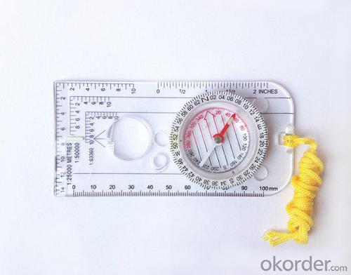


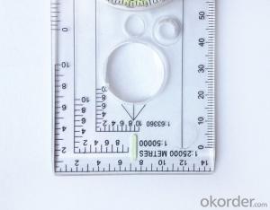
Map compass DC40-3A
- Ref Price:
-

- Loading Port:
- Tianjin
- Payment Terms:
- TT OR LC
- Min Order Qty:
- -
- Supply Capability:
- 5000 pc/month
OKorder Service Pledge
OKorder Financial Service
You Might Also Like


Product details
Model: DC40-3A
Name: Professional map compass, ruler compass
Product Origin: China
Supply Ability: 10,000 pcs/month
Minimum Order: 50 pcs
MOQ for OEM package: 500pcs
Weight: 39g
Color: OEM
Accuracy: ±1°
Features
1, professional usage: orientation, distance measuring, measuring slope, azimuth and pitching Angle measurement, drawing, a magnifying glass
2, high quality compass with neck rope, portable and rugged
3, ACRYLIC material, about 2mm thick
4, Damping Dial: to keep the stability of the pointer, more suitable for outdoor
environment.
5, Accuracy: accurate and clear, there were 360 degrees azimuth Angle, outer ring is 64-00 system, Liquid filled in the compass for reliable readings.
6, Magnifier function
- Q: GPS Mu meter which brand is good, handheld high-precision land area measuring instrument
- Simple operation, the screen is large, a few buttonsBoot, and then look at the star almost, to find a field, start and then click on the end of a circle, out of the number ofElectricity can alsoPrecision mody... With a special RTK or not, but what is sure to measure a circleFlat measurement of quasi accurate, biased on what is almost, it can be accepted
- Q: Can you buy a good handheld GPS in China? FiveTrouble master recommended several professional handheld GPS brand, in addition to handheld GPS can speed it? Thank you!!
- If it is used, there is no difference.
- Q: Is it accurate to measure highway mileage with GPS handheld
- As long as you can receive more than four satellites, and the signal is good, the accuracy should be high.
- Q: What is the difference between industrial GPS handset and mobile navigation
- 3, professional handheld machine with industrial design. First of all, if used outdoors, then fell, and so on are likely to water, and this thing is also very expensive, so the opportunity to have a high professional anti shock waterproof performance.4, different screen design. If you look carefully, you can see in the outdoor light, mobile phone can not see the contents of the screen, while the professional handset is not the same, can see clearly in bright light, does not affect the work of foreign trade operations.
- Q: Can a handheld navigator connect a cell phone? Thank you
- Now basically use the phoneEasy update and operation
- Q: What is GPS Mu meter ah, with the general said that the GPS measuring instrument what is the difference?
- GPS Mu meter also known as land area measuring instrument, handheld meter meter, etc.. Integrated computational methods for understanding and intelligent high precision GPS positioning system, the precise area of the handheld computer system, can realize the irregular area of real-time measurement and dynamic graphical display and intelligent data processing and storage.GPS measurement of the meter is different from the general GPS measuring instrument is based on the latitude and longitude of its area calculation function, general GPS is generally used for positioning.
- Q: Verify the accuracy of the GPS device to buy back, the way is to use Android under the'gps state 'software, to test the accuracy of real-time single point positioning.1 with two sets of the same Android Tablet Computer (custom machine, type of bad) in the same position for receiving, find that the accuracy is the same (software, are 1-2 meters), but the position would be poor 10 meters or more. It's in the same place.The 2 one is the Android tablet computer, a mobile phone is HTC G10, also received together in the same position, find that the accuracy is not the same as (the latter 20 meters or so), but also may be about 10 meters position difference.The accuracy of this GPS device can reach 1-2 meters, while the same location in real-time single point positioning error of 10 meters, a reasonable explanation.
- 10 meters.To the world in 2013 a total of four global satellite navigation system, in addition to the United States has been in the mature GPS system and commercial operation, the Beidou system, China the European Galileo system, the Russian GLONASS system are still under construction. "The Galileo satellite navigation project" was first conceived by the 30 satellite GPS network to compete with the United States, the beginning of the design proposed in 2008 formally put into operation, and later postponed to 2014, the entire system is only 4 satellites in orbit (as of 2012), in fact it is mainly used to further verify the relevant design and the working system of the system design, after the official start of Galileo satellite will launch. Formal networking satellites are being prepared. China satellite navigation system management office senior engineer Yang Qiangwen introduction, to 2012, the "system" in orbit satellites are also only verify satellite.
- Q: Handheld GPS and mobile phone GPS what is the difference?
- Handheld GPS also supports GPS compass navigation and map navigation as well as other more professional GPS applications; mobile GPS can work with fewer, more consumer grade product applications
- Q: The navigation module it is "selph" three generation? Another one I mainly use it to measure the land area, easy to use, the error is not big?I want to buy Magellan 500 do not know whether it is good to use
- A type specific.GPS chip area measurement is the most "selph" 3 generation, special machine is very good, the error is very small.
- Q: Magellan GPS handheld why so many people choose not to say that the map is not good
- Select the right access to GPS oh it has a contact information users
Send your message to us
Map compass DC40-3A
- Ref Price:
-
- Loading Port:
- Tianjin
- Payment Terms:
- TT OR LC
- Min Order Qty:
- -
- Supply Capability:
- 5000 pc/month
OKorder Service Pledge
OKorder Financial Service
Similar products


Hot products


Hot Searches

