


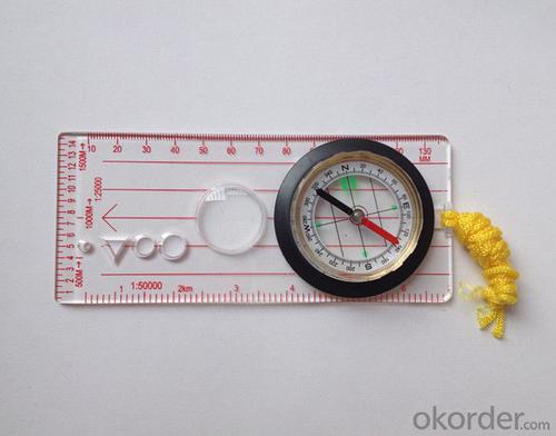


Transparant Map Scale Compass DC45-5D
- Ref Price:
-

- Loading Port:
- China Main Port
- Payment Terms:
- TT OR LC
- Min Order Qty:
- -
- Supply Capability:
- -
OKorder Service Pledge
OKorder Financial Service
You Might Also Like


Model: DC45-5D
Name: Professional map compass, ruler compass
Product Origin: China
Supply Ability: 10,000 pcs/month
Minimum Order: 50 pcs
MOQ for OEM package: 500pcs
Product Size: 140*61*17 (mm)
Features
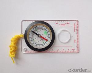
1, professional usage: orientation, distance measuring, measuring slope, azimuth and pitching Angle measurement, drawing, a magnifying glass
2, high quality compass with neck rope, portable and rugged
3, ACRYLIC material, about 2mm thick
4, Damping Dial: to keep the stability of the pointer, more suitable for outdoor
environment.
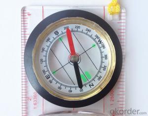
5, Accuracy: accurate and clear, there were 360 degrees azimuth Angle, outer ring is 64-00 system, Liquid filled in the compass for reliable readings.
6, Magnifier function
- Q: I would like to ask the GPS handset and GPS receiver (Surveying and mapping qualification application needs) is there a difference? If yes, what is the difference?
- 1. GPS is a geodetic instrument, with an accuracy of CM, generally for the millimeter,,Divided into (1) pure static type, such as the South Star of the North Star, the accuracy of mm, now the basic domestic,,(2) RTK, RTK can do is use, carrier phase measurement, the precision is cm level, RTK mobile station must have the control hand book, like television and remote similar, but now there are a lot of hand book can be used as handset2. The handset is generally rough field positioning equipment, navigation for mobile phone use, the general size, precision grade m, now can to about 20cm, and can be used for RTK mobile station use (need to access the base station) can reach cm level.Surveying and mapping qualification applications require geodetic measurement equipment, that is, 1.Now domestic GPS, such as the Haida, the south, China, etc. can be measured, not expensive
- Q: Handheld GPS positioning, can be directly uploaded to the computer, and the computer has a scalable map to mark the upload point. The above system, now there are 20Such as the title, I want to achieve the final function: through the manual to a point, with a hand-held GPS locator will be recorded in the specific latitude and longitude, and sent to the network in real time, for my computer to mark these points on the map. If you can directly enter the site of some of the information, directly to the above is the bestIf you have the above equipment, please indicate the scientific name, and the specific application industry.Thanks.
- 4 support coordinate query positioning, you can enter the coordinates of the value of the location of the query.5 support user defined information, advanced information query, real-time positioning results.6 support for the selected annotations on the map.
- Q: Handheld GPS locator measuring accuracy is about how many meters?
- The handheld machine precision is generally divided into: centimeter decimeter level, 1 meters, 2 meters, 3 meters, 5 meters;
- Q: Handheld GPS navigation is what? Where to buy handheld GPS navigation, how to select GPS navigation?
- Handheld GPS is mainly for GIS data acquisition, a lot of advanced GPS with PDA function, you can load navigation software for vehicle navigationBut the handheld GPS is mainly to do some engineering design, the main area can be measured, the location, and the boundary survey. GPS can do advanced vehicle navigation can also waypoint navigation, is a coordinate input to precise navigation to this position.Handheld GPS navigation is divided into 2 kinds, one is portable GPS navigation, one is used for surveying and mapping professional GPS handheld
- Q: What is the difference between industrial GPS handset and mobile navigation
- I am a professional to do GPS, the difference between the professional handheld and mobile GPS is very understanding, here and your simple communication.1, GPS is the most important positioning accuracy and confidence. Professional handheld GPS chip used to stabilize the performance of some, the accuracy will be better, such as Garmin handheld high-end product positioning can be achieved within 3 meters, while the phone's GPS chip is different.2, both in the design and positioning of the crowd is very different. Professional GPS more focus on outdoor industry and users, the use of design idea is how to better outdoors, outdoor tourism including tourism exploration assistant very full function, and mobile phone GPS is a trend not only, what purpose.
- Q: Mountaineering to buy a professional GPS or Mountaineering Watch
- There is no need to buy too many devices. Now the phone is an essential tool, the phone has GPS,
- Q: Welcome to make comments on the existing GPS tour pal what shortcomings to answer the more detailed the better
- Fifth elements: the terrain map is the main project of outdoor sports climbing, mountain climbing is very exhausting, we usually do a plan will be completed on schedule, a good plan should be to our destination in the manual run out before. And if you want to do this, it must be on the road difficult to have a correct anticipation. But this time, with the terrain map GPS can come in handy, the mountains and the altitude of the understanding, we need to know about these sections spend much time and energy. And the general GPS map, is unable to meet the needs. So we'd better buy a map with contour terrain data of professional grade GPS, make your own outdoor journey do in our hands.
- Q: In addition to the parameters, that is the problem of the machine, what method can reduce the error of these two machines to a minimum. Because, at the same time to find a coordinate. The gap is too big.
- GPS was in error with 10 meters, with the star search results, related to the environment, if the precision is high, as long as the use of handheld GPS submeter or handheld RTK
- Q: I just bought a handheld GPS Magellan No. 1, showing the latitude and longitude coordinates, I want to set the geodetic coordinates of latitude and longitude, do not know where to set, I would like to ask you, how to set, there is a better picture shows the best, thank you so much.Magellan GPS 210 is not 2000 shy
- 2 map reference setting: [[map] - unit "benchmark is set to User, and input the DX, DY, DZ, DA, DF parameters, usually DX, DY, DZ vary from region to region, so need to know the high level control points to solve, solving methods are as follows:The handheld GPS is placed in the control point field buried pile, were measured, and then hand coordinate coordinates and the known control points of the GPS measurements obtained for the poor, can be obtained by local coordinates and elevation deviation value: DX, DY, DZ.
- Q: Handheld GPS each brand has what difference; different price difference in where is the positioning accuracy is different or what function is not the same?What are the differences between the measurements and the cars?
- Where the speed of the car, how many miles are open at a glance at the professional GPS locator
Send your message to us
Transparant Map Scale Compass DC45-5D
- Ref Price:
-
- Loading Port:
- China Main Port
- Payment Terms:
- TT OR LC
- Min Order Qty:
- -
- Supply Capability:
- -
OKorder Service Pledge
OKorder Financial Service
Similar products


Hot products


Hot Searches
Related keywords

