


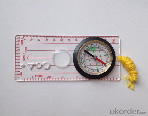


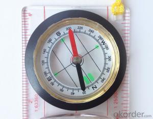
Transparant Map Scale Compass DC45-D
- Ref Price:
-

- Loading Port:
- China Main Port
- Payment Terms:
- TT OR LC
- Min Order Qty:
- -
- Supply Capability:
- -
OKorder Service Pledge
OKorder Financial Service
You Might Also Like


Model: DC45-5D
Name: Professional map compass, ruler compass
Product Origin: China
Supply Ability: 10,000 pcs/month
Minimum Order: 50 pcs
MOQ for OEM package: 500pcs
Product Size: 140*61*17 (mm)
Features
1, professional usage: orientation, distance measuring, measuring slope, azimuth and pitching Angle measurement, drawing, a magnifying glass
2, high quality compass with neck rope, portable and rugged
3, ACRYLIC material, about 2mm thick
4, Damping Dial: to keep the stability of the pointer, more suitable for outdoor
environment.
5, Accuracy: accurate and clear, there were 360 degrees azimuth Angle, outer ring is 64-00 system, Liquid filled in the compass for reliable readings.
6, Magnifier function
- Q: Handheld GPS buried in the soil there is a signal
- It depends on how deep you buried the darker the GPS signal, and must ensure that the GPS antenna upward, the above can not be covered with metal objects
- Q: GPS Mu meter which brand is good, handheld high-precision land area measuring instrument
- Simple operation, the screen is large, a few buttonsBoot, and then look at the star almost, to find a field, start and then click on the end of a circle, out of the number ofElectricity can alsoPrecision mody... With a special RTK or not, but what is sure to measure a circleFlat measurement of quasi accurate, biased on what is almost, it can be accepted
- Q: My friend is in use, the difference is not big, professional handset (smart or Magellan bulky, but 3 case), but the price is expensive, but can not call and map is very rotten, endurance of 10 hours (dry battery) the mobile phone also has all the time. Know friends say, I mainly in the suburbs! Thanks
- Two, different hardware configurationAs the field work environment is relatively poor, so waterproof, dustproof, shockproof for handheld GPS is very necessary. Handheld GPS on the market level of water is generally IPX7, and the continuous use of time is often more than 10 hours. Mobile phones are not so much demand. Handheld GPS function is relatively simple, and even most of the products are still grayscale display screen, multimedia features almost No.In the chip, there is not much difference between the GPS and GPS handheld mobile phone, mobile phone is commonly used in the Samsung 2440 chip and SIRF III receiving module on the handset is also very common, but in recent years MSTAR from Taiwan due to its advantages of cheap, very popular in the low-end handset.
- Q: Is it accurate to measure highway mileage with GPS handheld
- Measuring mileage, since the unit has been upgraded to the inside, it is quite accurate oh
- Q: How to set the handheld GPS related parameters and coordinate conversion parameters throughout the country
- Collect the application area of high grade control data in GPS receiver applied earth area (such as a county) find three (or more) uniform grade (accuracy better) or GPS "B" network, the best point is around without interference of electromagnetic wave, vision, the satellite signal is strong. To the local surveying and mapping management department (such as: the local bureau of Surveying and mapping, surveying and Mapping Institute) Gauss plane coordinate copy these points of the Beijing 54 Coordinate System (x, y), the elevation of H and WGS-84 coordinates of the geodetic coordinates (B, L), the high H.
- Q: I bought the way k20s, this handheld GPS how
- Ordinary hand-held GPS is 3-5 meter accuracy, high accuracy can be achieved unless buy submeter ordinary user, if you can.
- Q: How about the accuracy of the GPS handset?
- zhonghaida Qmini series: 3 meters; zhonghaida Qcool series: 5 meters; precision and price is proportional to the precision is higher, the higher the price.
- Q: The navigation module it is "selph" three generation? Another one I mainly use it to measure the land area, easy to use, the error is not big?I want to buy Magellan 500 do not know whether it is good to use
- A type specific.GPS chip area measurement is the most "selph" 3 generation, special machine is very good, the error is very small.
- Q: I just bought a handheld GPS Magellan No. 1, showing the latitude and longitude coordinates, I want to set the geodetic coordinates of latitude and longitude, do not know where to set, I would like to ask you, how to set, there is a better picture shows the best, thank you so much.Magellan GPS 210 is not 2000 shy
- 1 position: [format setting unit - "[] position display format is set to User UTM Grid, and enter the relevant parameters, such as the 3 degree or 6 degree with the area with the central meridian projection, the ratio was 1, that deviation is 500000m, north-south deviation is 0.2 map reference setting: [[map] - unit "benchmark is set to User, and input the DX, DY, DZ, DA, DF parameters, usually DX, DY, DZ vary from region to region, so need to know the high level control points to solve, solving methods are as follows:The handheld GPS is placed in the control point field buried pile, were measured, and then hand coordinate coordinates and the known control points of the GPS measurements obtained for the poor, can be obtained by local coordinates and elevation deviation value: DX, DY, DZ.
- Q: Ask how to select a google satellite map into a handheld Area GPS
- The ordinary mobile phone GPS, can install Orville interactive map support pre download any regional satellite map, support for offline use
Send your message to us
Transparant Map Scale Compass DC45-D
- Ref Price:
-
- Loading Port:
- China Main Port
- Payment Terms:
- TT OR LC
- Min Order Qty:
- -
- Supply Capability:
- -
OKorder Service Pledge
OKorder Financial Service
Similar products


Hot products


Hot Searches
Related keywords

