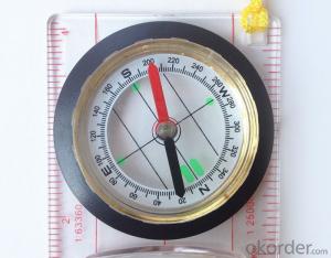


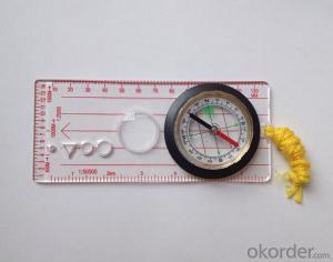
Transparant Map Scale Compass DC45-5B
- Ref Price:
-

- Loading Port:
- China Main Port
- Payment Terms:
- TT OR LC
- Min Order Qty:
- -
- Supply Capability:
- -
OKorder Service Pledge
OKorder Financial Service
You Might Also Like


Model: DC45-5B
Name: Professional map compass, ruler compass
Product Origin: China
Supply Ability: 10,000 pcs/month
Minimum Order: 50 pcs
MOQ for OEM package: 500pcs
Product Size: 112*62*17(mm)
Features
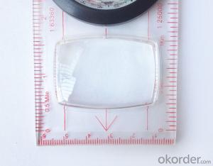
1, professional usage: orientation, distance measuring, measuring slope, azimuth and pitching Angle measurement, drawing, a magnifying glass
2, high quality compass with neck rope, portable and rugged
3, ACRYLIC material, about 2mm thick
4, Damping Dial: to keep the stability of the pointer, more suitable for outdoor
environment.
5, Accuracy: accurate and clear, there were 360 degrees azimuth Angle, outer ring is 64-00 system, Liquid filled in the compass for reliable readings.
6, Magnifier function
- Q: Highway measurement with GPS I do not know which of the base station settings and mobile station settings I are very vague, to the instrument to build a coordinate system how to build the relevant issues to me
- Defects of conventional measurement methods:1, the specification of the length of the attached wire, the length of the wire and the length of the wire between the nodes have strict requirements, generally for high grade roads are required to meet the requirements of the first line. In this way, the length of the wire shall not be more than 10 km, or the length of the wire shall not exceed the length of the wire attached to the attachment of the wire length of 0.7 times. This requirement is generally difficult to achieve in the actual work, often appear super standardized operations.2, to collect the starting point for the general route of measurement and control is difficult to ensure the same measurement system, the measurement and measurement, often in the city of control points mixed together, the compatibility between systems, if the starting point is not compatible, is bound to affect the quality of measurement.3, serious damage to the national site, the impact of measurement operations. Due to the country's basic control points, mostly completed in 50s and 60s, after more than 30 years, some point due to the needs of economic construction is destroyed, and some people because of the lack of knowledge of human destruction. Route survey work in these areas, often in the 50 km above all can not find the wire control points. The quality of the route control survey is not guaranteed.4, ground visibility difficulties often affect the implementation of conventional measurement. The control points of the general route shall be located within 300 meters from the course. Due to visibility reasons, it is difficult to meet the conditions, even in a large range, and the dense shrub forest area, simply can not implement conventional control measure.
- Q: Handheld GPS need to put the phone card?
- Hello, now the general GPS are required to put the card! Thanks
- Q: Handheld GPS how to achieve decimeter
- "Shaanxi skmax navigation information Limited" GARMIN proxy (GARMIN official website can be found), contact (Xiao Hou) the hope can help to you, if you do not understand what we see on the Internet, may at any time, contact us
- Q: Can you buy a good handheld GPS in China? FiveTrouble master recommended several professional handheld GPS brand, in addition to handheld GPS can speed it? Thank you!!
- If it is used, there is no difference.
- Q: Handheld GPS which brand is good
- Now GPS can also do handheld measurement accuracy, precision can usually reach decimeter level, the industry there are relatively well-known Huace, professional GPS measurement instrument, high precision of handheld GPS the good.
- Q: How do I still stay in the GPS navigation, GPS monitoring of the primary idea? FiveBusiness services, thank you!Future business services
- Mainly for the ship, automobile, aircraft and other moving objects positioning navigation. For example:1 ocean navigation and incoming water diversion2 aircraft route guidance and approach landing3 vehicle autonomous navigation4 ground vehicle tracking and urban intelligent traffic management5 emergency rescue
- Q: How to use the handheld GPS whole watershed investigation
- Some people think that the use of critical state to solve the most value should be cautious, we must first distinguish the relationship between the two states
- Q: I am a handheld GPS precision is low, how to use to be able to improve certain accuracy
- If the carrier phase measurement function is not available, you have the maximum accuracy of GPS accuracy of 1-10This can only improve the observation environment using SBAS and other ways to improve the accuracy
- Q: Handheld GPS, the measurement of arable land, fixed point and circle test, which is more accurate,
- If the area is measured, are almost. However, if the measurement point is only the case, the dynamic GPS is now the general error can be guaranteed within 3cm, the total station can be guaranteed to the millimeter.
- Q: What qualifications should a normal GPS locator have?
- Patent, business licenseLook what kind of
Send your message to us
Transparant Map Scale Compass DC45-5B
- Ref Price:
-
- Loading Port:
- China Main Port
- Payment Terms:
- TT OR LC
- Min Order Qty:
- -
- Supply Capability:
- -
OKorder Service Pledge
OKorder Financial Service
Similar products


Hot products


Hot Searches
Related keywords

