
Surveying GIS K9
- Ref Price:
-

- Loading Port:
- China Main Port
- Payment Terms:
- TT OR LC
- Min Order Qty:
- -
- Supply Capability:
- -
OKorder Service Pledge
OKorder Financial Service
You Might Also Like


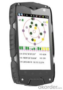
PJK 8 is a GPS data collection devices based with smart tablet Android operating system; 3.5 Cunban through the half- screen which is visible under bright light , high-resolution , ultra-thin , rugged design, easy to complete the wild variety of environments data collection ; built-in 3G data acquisition allows interaction within and outside the industry that has quickly realized .
Product Features
1, the basic functions
Operating system : Android 4.0, massive applications at your fingertips
Processor : 1GHZ processor speed
Memory capacity RAM: 512MB ROM: 4G
Memory card : MicroSD (TF) card , up to 32GB
2 , data collection
Data acquisition system with professional mobile GIS data collection , field mapping, waypoint storage coordinates to calculate the length , angle , and other areas of field measurement data , with a key two-coordinate conversion function .
3, GPS features
Differential : Support SBAS (MSAS, WAAS, EGNOS)
Real-time differential :1-3m
Single precision :3-5m
4 , communication performance
Built-in GSM and WCDMA communications , high-speed data transfer easy , can support voice calls
Bluetooth : 2.1 + EDR
WIFI: Support 802.11 Wireless LAN
USB: 2.0
5, the extended application
5 million pixel camera , 300,000 auto-focus camera ,
Video capture,
Built-in microphone supports voice attribute collection
Built-in electronic compass ,
Under no circumstances can indicate GPS direction , support multiple GPS intelligent navigation software
Support for emergency lighting and portrait and landscape screen automatically switches .
1, the physical properties of
Size : 125 * 65.5 * 20.5MM
Weight : 204G
Working temperature: -20 to 65 degrees
Storage temperature : -40 ℃ ~ 70 ℃
Humidity : 100 % non-condensing
Waterproof and dustproof : IP67
Anti- fall drop : Anti 1.5 meters free fall
Roll : Roll 1000 0.5 m height
Rugged and lightweight : GE Industrial grade high fire-retardant materials plus lightweight structure designed to allow field operations no longer be a burden.
2 , the display characteristics
Display: 3.5 -inch
Type: Multi -point capacitive touch screen
Brightness: anti-glare display, highlight
Resolution : 320 × 480
3, the power characteristics
Battery : 2000mAH Lithium Battery
Working hours : 10 hours of continuous work
4 ,Quality Certification
Product complies with EU CE, ROSH standards, China 's national quasi- GB 21288-2007 requirements
- Q: What factors affect the handheld GPS receive signal?
- In addition to not see the sky (such as indoor, underground, dense forest) and narrow alleys and tall buildings on both sides of the environment, there will be no impact. Many GPS has 12 receivers (antenna unit), as long as it can capture 3 satellites can be three-dimensional positioning (including height), the 2 satellites can be flat positioning.
- Q: I would like to ask the GPS handset and GPS receiver (Surveying and mapping qualification application needs) is there a difference? If yes, what is the difference?
- This is the case, GPS handheld refers to a thin hand, while the GPS receiver refers to the RTK host, equivalent to the base station in our industry said. The general application of Surveying and mapping qualifications are required for this application, referred to as RTK (1+1) set, level, theodolite, total station, walkie talkie, technical personnel.... And so on, are essential equipment.
- Q: Handheld GPS buried in the soil there is a signal
- It depends on how deep you buried the darker the GPS signal, and must ensure that the GPS antenna upward, the above can not be covered with metal objects
- Q: Hand held GPS coordinate conversion method
- Two. To coordinate the coordinate data of the control points obtained provide technical support unit of Beijing Unistrong companies around the branch responsible person to calculate the coordinate transformation parameters conversion parameters, or to obtain their own conversion conversion software. After the conversion parameters are calculated by the prompt input handheld GPS. Only after such a setup, after all the soil in the region when the coordinates of the GPS read out the coordinates of the point for the Beijing 54 coordinates.
- Q: What is GPS Mu meter ah, with the general said that the GPS measuring instrument what is the difference?
- If it's just a GPS meter and a GPS meter, that's a thing.If the measuring instrument, it is not the same with the measured mu instrument.In fact, these GPS is actually said handheld gps.It is used in measuring area and used in agriculture, forestry and animal husbandry.Handheld GPS generally have the function of measuring area.For example, Magellan, Gao Tianxiang handheld GPS etc. These are very famous, each model has the function of measuring areaWe have some stores!
- Q: Handheld GPS charge is not into electricity what is the reason
- Two, solutions:1, for other chargers, or data lines try, or clean the charging port.2, boot into recover mode advancsd advanced mode, select the wipe Battery, remove battery traces.
- Q: Handheld GPS and mobile phone GPS what is the difference?
- Different: antenna size, function, accuracy, protection level, and has been different in the application layer (handheld GPS support GPS compass navigation and map navigation and other more professional GPS applications);
- Q: Welcome to make comments on the existing GPS tour pal what shortcomings to answer the more detailed the better
- The first three factors: ability as a good tour pal, sun and rain fearless tramp over mountains and through ravines Rulvpingdi, GPS, his nature can not be weak, small knock a small touch can not have temper, off or out in the water dirty, also to be able to continue the work. So the waterproof / earthquake / dust and other indicators become the primary consideration factors GPS these are the protective ability of vehicle GPS, most of them do not have, and some professional GPS design, there will be more conducive to the harsh environment, such as some of the products designed to be capable of floating after falling into the water. The outdoor need to step back. What is it, if you can not do to prevent flooding, then rain proof ability is the minimum requirement.
- Q: How the German born handheld GPS Mu meter, I want to buy?
- The data acquisition function of scientific, simple and accurate measurement of area, display area and the "Mu", "price" area can be set automatically calculate the area of "price", fit the actual demand Chinese industry users on the data collection and usage, highlighting the professional quality.Is the highest cost-effective mid-range machine
- Q: What qualifications should a normal GPS locator have?
- Patent, business licenseLook what kind of
Send your message to us
Surveying GIS K9
- Ref Price:
-
- Loading Port:
- China Main Port
- Payment Terms:
- TT OR LC
- Min Order Qty:
- -
- Supply Capability:
- -
OKorder Service Pledge
OKorder Financial Service
Similar products

Hot products


Hot Searches

