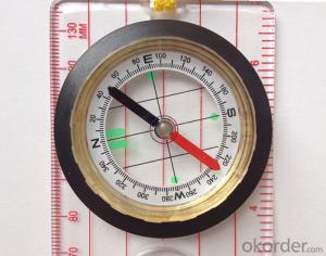


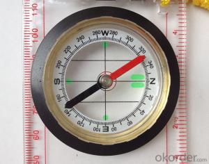
Professional Map Mini-Compass DC45-5D for Serveying
- Ref Price:
-

- Loading Port:
- Tianjin
- Payment Terms:
- TT OR LC
- Min Order Qty:
- 20 pc
- Supply Capability:
- 10000 pc/month
OKorder Service Pledge
OKorder Financial Service
You Might Also Like


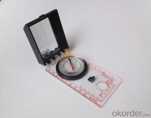

Model: DC45-5D
Name: Professional map compass, ruler compass
Product Origin: China
Supply Ability: 10,000 pcs/month
Minimum Order: 20 pcs
MOQ for OEM package: 500pcs
Product Size: 140*61*17 (mm)
Features of DC45-5D
1, professional usage: orientation, distance measuring, measuring slope, azimuth and pitching Angle measurement, drawing, a magnifying glass
2, high quality compass with neck rope, portable and rugged
3, ACRYLIC material, about 2mm thick
4, Damping Dial: to keep the stability of the pointer, more suitable for outdoor environment.
5, Accuracy: accurate and clear, there were 360 degrees azimuth Angle, outer ring is 64-00 system, Liquid filled in the compass for reliable readings.
6, Magnifier function
5,ruler compass,
6,for map measure and drawing
7,one meter neck rope,
8,Liquid filled in the compass for reliable readings,
9, magnifier function.
- Q: Handheld GPS buried in the soil there is a signal
- It depends on how deep you buried the darker the GPS signal, and must ensure that the GPS antenna upward, the above can not be covered with metal objects
- Q: What is the difference between industrial GPS handset and mobile navigation
- 5, strong battery life, is a major feature of professional GPS, Garmin handset General of dry batteries can be used more than ten hours, while the mobile phone GPS on GPS also can use a few hours, if you open the GPS in general about 3 hours will be over.6, supporting different software. Professional GPS handheld opportunities related to the PC end of the data processing software, this software can achieve the acquisition of data processing, as well as the application of data collection. The phone GPS can only navigation, and navigation is only a small part of the GPS function.I simply say these, this is my personal summary of the difference, if you have what is not clear can exchange. Want to help you.
- Q: What is the difference between the phone's GPS and professional handheld GPS features and differences?
- If you travel enthusiasts so you still recommend buying the handheld bar dry batteries can be replaced immediately if it is built in deep mountains and forests where you go oh for charging software installation, you can go to the forum to see the relevant system is very simple and the most important point is that basically all the navigation software has cracked the free version allows you to use it here and I hope to help you
- Q: Hand held GPS coordinate conversion method
- By the 84 coordinates to Beijing 54 Coordinate. A collection of application area of high grade control data in GPS receiver applied earth area (such as a county) find three (or more) uniform grade (accuracy better) or GPS "B" dot, point the best is around without interference of electromagnetic wave, vision, satellite signal. To the local surveying and mapping management department (such as: the local bureau of Surveying and mapping, surveying and Mapping Institute) Gauss plane coordinate copy these points of the Beijing 54 Coordinate System (x, y), the elevation of H and WGS-84 coordinates of the geodetic coordinates (B, L), the high H.
- Q: Professional handheld GPS GARMIN (DR) how to use
- Handheld GPS purposes, the measurement of soil area, linear navigation, auxiliary fishing waypoint navigation point information, traffic data display, such as the use of functional machines should be used manual
- Q: Mobile GPS can replace professional handheld GPS
- No, professional signal and positioning more accurate,Walk along the plots in a circle can measure the size and graphics trajectory, 550 yuan, USB charging, large capacity lithium battery, black and white screen to see the clear day for outdoor use.
- Q: What is GPS Mu meter ah, with the general said that the GPS measuring instrument what is the difference?
- GPS Mu meter also known as land area measuring instrument, handheld meter meter, etc.. Integrated computational methods for understanding and intelligent high precision GPS positioning system, the precise area of the handheld computer system, can realize the irregular area of real-time measurement and dynamic graphical display and intelligent data processing and storage.GPS measurement of the meter is different from the general GPS measuring instrument is based on the latitude and longitude of its area calculation function, general GPS is generally used for positioning.
- Q: Handheld GPS charge is not into electricity what is the reason
- Reason analysis:1, battery damage. 2, system failure. 3, charger reasons or bad contact.
- Q: Handheld GPS and mobile phone GPS what is the difference?
- The same: GPS main chip may be the same; can complete the GPS positioning;
- Q: Handheld GPS each brand has what difference; different price difference in where is the positioning accuracy is different or what function is not the same?What are the differences between the measurements and the cars?
- I was engaged in car GPS positioning, the first difference between different prices is the biggest cost of different module determines the price, this is the precise positioning of the key, but also the guarantee of product quality, rather than low-cost copycat version, as a kind of different price mobile phone, why Apple four generation sell so expensive but, only a few hundred to copycat.
Send your message to us
Professional Map Mini-Compass DC45-5D for Serveying
- Ref Price:
-
- Loading Port:
- Tianjin
- Payment Terms:
- TT OR LC
- Min Order Qty:
- 20 pc
- Supply Capability:
- 10000 pc/month
OKorder Service Pledge
OKorder Financial Service
Similar products


Hot products


Hot Searches

