


Professional Map Mini-Compass DC45-6A for Surveying
- Ref Price:
-

- Loading Port:
- Tianjin
- Payment Terms:
- TT OR LC
- Min Order Qty:
- 20 pc
- Supply Capability:
- 10000 pc/month
OKorder Service Pledge
OKorder Financial Service
You Might Also Like


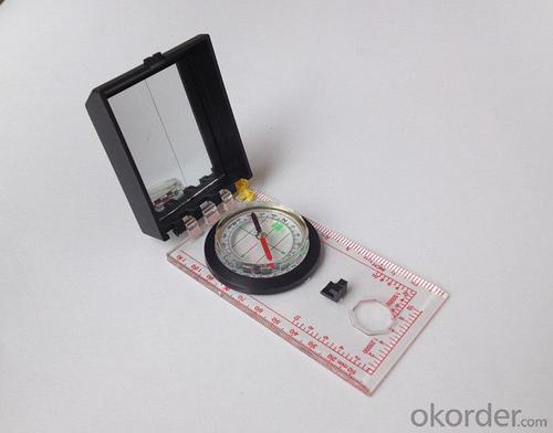
Model: DC45-6A
Name: Professional map compass, ruler compass
Product Origin: China
Supply Ability: 10,000 pcs/month
Minimum Order: 20 pcs
MOQ for OEM package: 500pcs
Product Size: 122*64*22 (mm)
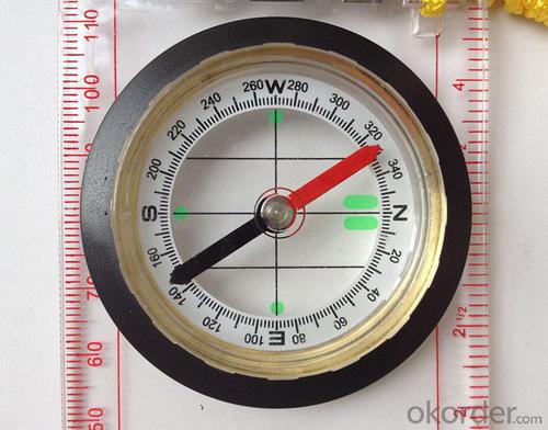
Features of DC45-6A
1, professional usage: orientation, distance measuring, measuring slope, azimuth and pitching Angle measurement, drawing, a magnifying glass
2, high quality compass with neck rope, portable and rugged
3, ACRYLIC material, about 2mm thick
4, Damping Dial: to keep the stability of the pointer, more suitable for outdoor environment.
5, Accuracy: accurate and clear, there were 360 degrees azimuth Angle, outer ring is 64-00 system, Liquid filled in the compass for reliable readings.
6, Magnifier function
5,ruler compass,
6,for map measure and drawing
7,one meter neck rope,
8,Liquid filled in the compass for reliable readings,
9, magnifier function.
- Q: Highway measurement with GPS I do not know which of the base station settings and mobile station settings I are very vague, to the instrument to build a coordinate system how to build the relevant issues to me
- For long tunnels, the conventional measurement of large bridges has the following limitations:1, long tunnels, bridges and other structures generally require the measurement level of four or more. With conventional measurement methods, often adopt the measure to increase the number of methods to extend the observation time, time consumption and labor consumption to try to improve the accuracy of.2, the long tunnel and bridge for the complex terrain region difficult, conventional control measure for visibility and network shape, often cut down the workload is quite large, so the measurement of the cost of a large, hard work.Link control network of high precision 3, long tunnel and bridge and low precision and route network, although with adjustment methods can be overcome, but because of the terrain conditions are difficult, the measurement workload to its connection, and is not too easy. In practical work, the control of the structure and the measurement of the route are often out of touch.
- Q: Is it accurate to measure highway mileage with GPS handheld
- Measuring mileage, since the unit has been upgraded to the inside, it is quite accurate oh
- Q: Can a handheld navigator connect a cell phone? Thank you
- Mobile navigator can downloadOther purchases can not beNow basically use the phoneEasy update and operation
- Q: I am a handheld GPS precision is low, how to use to be able to improve certain accuracy.
- Look at the maximum accuracy of GPSIf the difference accuracy can reach 1cm you can connect CORS single base station and other network RTK way to achieve the corresponding accuracy
- Q: Handheld GPS brand rankings
- Set of SIBAO products awarded the Beijing independent innovation product identification certificate, satellite navigation and Engineering Excellence Award and other professional awards. At the time, location, navigation and other comprehensive applications, Unistrong successful implementation of hundreds of large projects, services in many national key projects, won the national honor.
- Q: What do you need to test for GPS?
- 5.DGPS you know, differential GPS (DGPS) positioning accuracy is very high, some GPS equipment providers set up a DGPS transmitter in some areas, free of charge to its customers, if customers are buying GPS receivers with DGPS function. The DGPS transmitter is a fixed GPS receiver (in a 100km ~ 200km exploration scene in the radius setting) receive satellite signals, it knows exactly what is the exact time of transmitting satellite signal to the theory, and then compare it with the actual delivery time, then calculate the "difference", influence this is very close to the atmospheric refraction, it will send out the difference, usually with FM (FM) radio data transmission using subcarrier modulation signal in the baseband receiver, GPS and DGPS function can receive and use it more accurate positioning.
- Q: I am a handheld GPS precision is low, how to use to be able to improve certain accuracy
- Look at the maximum accuracy of GPSIf the difference accuracy can reach 1cm you can connect CORS single base station and other network RTK way to achieve the corresponding accuracy
- Q: The navigation module it is "selph" three generation? Another one I mainly use it to measure the land area, easy to use, the error is not big?I want to buy Magellan 500 do not know whether it is good to use
- Professional handheld GPS only Magellan and set SIBAO
- Q: I just bought a handheld GPS Magellan No. 1, showing the latitude and longitude coordinates, I want to set the geodetic coordinates of latitude and longitude, do not know where to set, I would like to ask you, how to set, there is a better picture shows the best, thank you so much.Magellan GPS 210 is not 2000 shy
- 1 position: [format setting unit - "[] position display format is set to User UTM Grid, and enter the relevant parameters, such as the 3 degree or 6 degree with the area with the central meridian projection, the ratio was 1, that deviation is 500000m, north-south deviation is 0.2 map reference setting: [[map] - unit "benchmark is set to User, and input the DX, DY, DZ, DA, DF parameters, usually DX, DY, DZ vary from region to region, so need to know the high level control points to solve, solving methods are as follows:The handheld GPS is placed in the control point field buried pile, were measured, and then hand coordinate coordinates and the known control points of the GPS measurements obtained for the poor, can be obtained by local coordinates and elevation deviation value: DX, DY, DZ.
- Q: Handheld GPS each brand has what difference; different price difference in where is the positioning accuracy is different or what function is not the same?What are the differences between the measurements and the cars?
- Engage in measurement and what is the difference between the car I do not know, look at the car to see if the functionSMS + Mobile Internet + computer network platform! 3 ways to check the car!
Send your message to us
Professional Map Mini-Compass DC45-6A for Surveying
- Ref Price:
-
- Loading Port:
- Tianjin
- Payment Terms:
- TT OR LC
- Min Order Qty:
- 20 pc
- Supply Capability:
- 10000 pc/month
OKorder Service Pledge
OKorder Financial Service
Similar products


Hot products


Hot Searches

