
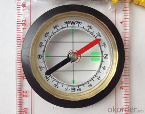


Map compass DC45-6A
- Ref Price:
-

- Loading Port:
- Tianjin
- Payment Terms:
- TT OR LC
- Min Order Qty:
- -
- Supply Capability:
- 5000 pc/month
OKorder Service Pledge
OKorder Financial Service
You Might Also Like


Product details
Model: DC45-6A
Name: Professional map compass, ruler compass
Product Origin: China
Supply Ability: 10,000 pcs/month
Minimum Order: 50 pcs
MOQ for OEM package: 500pcs
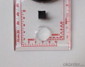
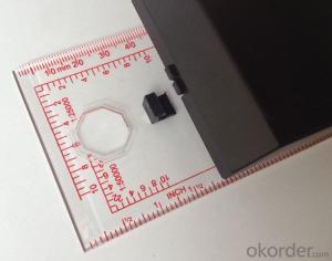
Product Size: 122*61*22 (mm)
Color: OEM
Features
1, professional usage: orientation, distance measuring, measuring slope, azimuth and pitching Angle measurement, drawing, a magnifying glass
2, high quality compass with neck rope, portable and rugged
3, ACRYLIC material, about 2mm thick
4, Damping Dial: to keep the stability of the pointer, more suitable for outdoor
environment.
5, Accuracy: accurate and clear, there were 360 degrees azimuth Angle, outer ring is 64-00 system, Liquid filled in the compass for reliable readings.
6, Magnifier function
- Q: Handheld GPS how to achieve decimeter
- "Shaanxi skmax navigation information Limited" GARMIN proxy (GARMIN official website can be found), contact (Xiao Hou) the hope can help to you, if you do not understand what we see on the Internet, may at any time, contact us
- Q: How to set the handheld GPS related parameters and coordinate conversion parameters throughout the country
- Collect the application area of high grade control data in GPS receiver applied earth area (such as a county) find three (or more) uniform grade (accuracy better) or GPS "B" network, the best point is around without interference of electromagnetic wave, vision, the satellite signal is strong. To the local surveying and mapping management department (such as: the local bureau of Surveying and mapping, surveying and Mapping Institute) Gauss plane coordinate copy these points of the Beijing 54 Coordinate System (x, y), the elevation of H and WGS-84 coordinates of the geodetic coordinates (B, L), the high H.
- Q: What is the difference between industrial GPS handset and mobile navigation
- I am a professional to do GPS, the difference between the professional handheld and mobile GPS is very understanding, here and your simple communication.1, GPS is the most important positioning accuracy and confidence. Professional handheld GPS chip used to stabilize the performance of some, the accuracy will be better, such as Garmin handheld high-end product positioning can be achieved within 3 meters, while the phone's GPS chip is different.2, both in the design and positioning of the crowd is very different. Professional GPS more focus on outdoor industry and users, the use of design idea is how to better outdoors, outdoor tourism including tourism exploration assistant very full function, and mobile phone GPS is a trend not only, what purpose.
- Q: I bought the way k20s, this handheld GPS how
- Ordinary hand-held GPS is 3-5 meter accuracy, high accuracy can be achieved unless buy submeter ordinary user, if you can.
- Q: What is the difference between professional GPS handsets and mobile navigation?
- First of all, if used outdoors, then fell, and so on are likely to water, and this thing is also very expensive, so the opportunity to have a high professional anti shock waterproof performance. You can see the Challenger I tour the next 600, three well plates.
- Q: GPS handheld function to measure it?
- Depends on the accuracy of the range you require, if the accuracy of the 3-5 meter can be used for ranging, measuring area, latitude and longitude, elevation information, etc.
- Q: Magellan GPS handheld why so many people choose not to say that the map is not good
- Select the right access to GPS oh it has a contact information users
- Q: How the German born handheld GPS Mu meter, I want to buy?
- The data acquisition function of scientific, simple and accurate measurement of area, display area and the "Mu", "price" area can be set automatically calculate the area of "price", fit the actual demand Chinese industry users on the data collection and usage, highlighting the professional quality.Is the highest cost-effective mid-range machine
- Q: Handheld GPS, the measurement of arable land, fixed point and circle test, which is more accurate,
- If the area is measured, are almost. However, if the measurement point is only the case, the dynamic GPS is now the general error can be guaranteed within 3cm, the total station can be guaranteed to the millimeter.
- Q: What qualifications should a normal GPS locator have?
- Patent, business licenseLook what kind of
Send your message to us
Map compass DC45-6A
- Ref Price:
-
- Loading Port:
- Tianjin
- Payment Terms:
- TT OR LC
- Min Order Qty:
- -
- Supply Capability:
- 5000 pc/month
OKorder Service Pledge
OKorder Financial Service
Similar products


Hot products


Hot Searches

