


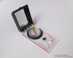
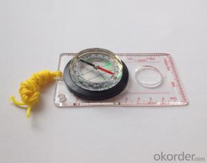
Acrylic Map compass DC45-5A
- Ref Price:
-

- Loading Port:
- Tianjin
- Payment Terms:
- TT OR LC
- Min Order Qty:
- -
- Supply Capability:
- 5000 pc/month
OKorder Service Pledge
OKorder Financial Service
You Might Also Like


Product details
Model: DC45-5A
Name: Professional map compass, ruler compass
Product Origin: China
Supply Ability: 10,000 pcs/month
Minimum Order: 50 pcs
MOQ for OEM package: 500pcs
Product Size: 109*61*17 (mm)
Color: OEM
Features
1, professional usage: orientation, distance measuring, measuring slope, azimuth and pitching Angle measurement, drawing, a magnifying glass
2, high quality compass with neck rope, portable and rugged
3, ACRYLIC material, about 2mm thick
4, Damping Dial: to keep the stability of the pointer, more suitable for outdoor
environment.
5, Accuracy: accurate and clear, there were 360 degrees azimuth Angle, outer ring is 64-00 system, Liquid filled in the compass for reliable readings.
6, Magnifier function
- Q: Highway measurement with GPS I do not know which of the base station settings and mobile station settings I are very vague, to the instrument to build a coordinate system how to build the relevant issues to me
- Application of GPS in Highway SurveyHighway routes are generally in a ribbon corridor. It is often used in the plane control measurement, which includes the form of wire, closed wire, wire and so on. For important structures such as bridges, bridges, tunnels, etc., but also arranged into triangular network, linear lock and other forms.
- Q: I would like to ask the GPS handset and GPS receiver (Surveying and mapping qualification application needs) is there a difference? If yes, what is the difference?
- 1. GPS is a geodetic instrument, with an accuracy of CM, generally for the millimeter,,Divided into (1) pure static type, such as the South Star of the North Star, the accuracy of mm, now the basic domestic,,(2) RTK, RTK can do is use, carrier phase measurement, the precision is cm level, RTK mobile station must have the control hand book, like television and remote similar, but now there are a lot of hand book can be used as handset2. The handset is generally rough field positioning equipment, navigation for mobile phone use, the general size, precision grade m, now can to about 20cm, and can be used for RTK mobile station use (need to access the base station) can reach cm level.Surveying and mapping qualification applications require geodetic measurement equipment, that is, 1.Now domestic GPS, such as the Haida, the south, China, etc. can be measured, not expensive
- Q: My friend is in use, the difference is not big, professional handset (smart or Magellan bulky, but 3 case), but the price is expensive, but can not call and map is very rotten, endurance of 10 hours (dry battery) the mobile phone also has all the time. Know friends say, I mainly in the suburbs! Thanks
- Two, different hardware configurationAs the field work environment is relatively poor, so waterproof, dustproof, shockproof for handheld GPS is very necessary. Handheld GPS on the market level of water is generally IPX7, and the continuous use of time is often more than 10 hours. Mobile phones are not so much demand. Handheld GPS function is relatively simple, and even most of the products are still grayscale display screen, multimedia features almost No.In the chip, there is not much difference between the GPS and GPS handheld mobile phone, mobile phone is commonly used in the Samsung 2440 chip and SIRF III receiving module on the handset is also very common, but in recent years MSTAR from Taiwan due to its advantages of cheap, very popular in the low-end handset.
- Q: I bought the way k20s, this handheld GPS how
- Choi way handheld GPS feel that you can also be in the last year, the Zhengzhou Bureau of Surveying and mapping seems to be called the wide Han instrument that home to buy, so there is no problem with it, the price is not expensive.
- Q: Handheld GPS which brand is good
- Now GPS can also do handheld measurement accuracy, precision can usually reach decimeter level, the industry there are relatively well-known Huace, professional GPS measurement instrument, high precision of handheld GPS the good.
- Q: My cell phone: HTC Hero 200Question type: Internet softwareMy work needs to locate, record, output, and input GPS coordinates. Track record measurement, coordinate transformation. So would you have a professional security software under the table, so go out with a mobile phone or a PAD, or N equipment back to survey the tired,
- Taobao to enter the online shopping, mobile phone navigator on the line, I suggest you download the Careland navigation map, or tiger map
- Q: Saying that we have a project in front of it is to do so, it is surprising that there are wood
- Hello friends, so, do 1:2000 topographic mapping with a handheld GPS is obviously not reality, after all, the handheld GPS precision is, however, now we are in the handheld equipment is no GPS, in fact, in the absence of the base station is a handheld GPS, receiving SBAS difference can reach sub meter level, but if a base station or receive CROS network differential signal will be RTK mobile station,
- Q: I just bought a handheld GPS Magellan No. 1, showing the latitude and longitude coordinates, I want to set the geodetic coordinates of latitude and longitude, do not know where to set, I would like to ask you, how to set, there is a better picture shows the best, thank you so much.Magellan GPS 210 is not 2000 shy
- 1 position: [format setting unit - "[] position display format is set to User UTM Grid, and enter the relevant parameters, such as the 3 degree or 6 degree with the area with the central meridian projection, the ratio was 1, that deviation is 500000m, north-south deviation is 0.2 map reference setting: [[map] - unit "benchmark is set to User, and input the DX, DY, DZ, DA, DF parameters, usually DX, DY, DZ vary from region to region, so need to know the high level control points to solve, solving methods are as follows:The handheld GPS is placed in the control point field buried pile, were measured, and then hand coordinate coordinates and the known control points of the GPS measurements obtained for the poor, can be obtained by local coordinates and elevation deviation value: DX, DY, DZ.
- Q: How to upgrade handheld navigator
- Hello to the brand's official website to download the latest map copy to memory card on the lineI wish you a pleasant car!
- Q: Handheld GPS purchaseHandheld GPS navigator!Is mainly used for tourism, I said is not a mobile phone, is a more professional handheld GPS navigator for travel outside! Handheld GPS navigator can voice navigation?
- Many outdoor enthusiasts are used to this, hiking, cycling and other applications are relatively wide, is an American brand, Mr Zelen back to U.S. Army GPS, and as Ma Ying-Jeou ring when riding on the handlebars also put a good 60CSX. the two brands in the nature, the price is more expensive, are in more than 2000, but the best is to the store to buy. If only for tourism, generally hundreds of pieces of GPS will be enough, go to computer city to see, must be sold, or go to your city in the outdoor store to see.
Send your message to us
Acrylic Map compass DC45-5A
- Ref Price:
-
- Loading Port:
- Tianjin
- Payment Terms:
- TT OR LC
- Min Order Qty:
- -
- Supply Capability:
- 5000 pc/month
OKorder Service Pledge
OKorder Financial Service
Similar products


Hot products


Hot Searches

