


Professional Map Mini-Compass DC35F for Surveying
- Ref Price:
-

- Loading Port:
- Tianjin
- Payment Terms:
- TT OR LC
- Min Order Qty:
- 20 pc
- Supply Capability:
- 10000 pc/month
OKorder Service Pledge
OKorder Financial Service
You Might Also Like


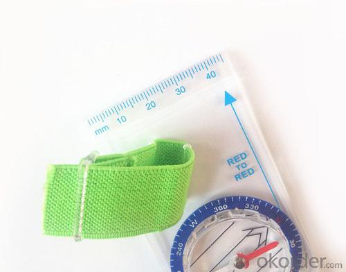
Model: DC35F
Name: Professional map compass, ruler compass
Product Origin: China
Supply Ability: 10,000 pcs/month
Minimum Order: 20 pcs
MOQ for OEM package: 500pcs
Product Size: 128*60*16 (mm)
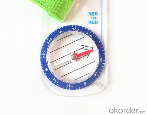
Features of DC35F
1, professional usage: orientation, distance measuring, measuring slope, azimuth and pitching Angle measurement, drawing, a magnifying glass
2, high quality compass with neck rope, portable and rugged
3, ACRYLIC material, about 2mm thick
4, Damping Dial: to keep the stability of the pointer, more suitable for outdoor environment.
5, Accuracy: accurate and clear, there were 360 degrees azimuth Angle, outer ring is 64-00 system, Liquid filled in the compass for reliable readings.
6, Magnifier function
5,ruler compass,
6,for map measure and drawing
7,one meter neck rope,
8,Liquid filled in the compass for reliable readings,
9, magnifier function.
- Q: I would like to ask the GPS handset and GPS receiver (Surveying and mapping qualification application needs) is there a difference? If yes, what is the difference?
- This is the case, GPS handheld refers to a thin hand, while the GPS receiver refers to the RTK host, equivalent to the base station in our industry said. The general application of Surveying and mapping qualifications are required for this application, referred to as RTK (1+1) set, level, theodolite, total station, walkie talkie, technical personnel.... And so on, are essential equipment.
- Q: Handheld GPS how to achieve decimeter
- Hello A GPS is not up to the requirements of the class, if no one can buy that expensive submeter GPS, currently on the market with the best precision is GPS, is Derek GARMIN this year a new eTrex 10, 20 and 30, the three can be reached within 3 meters accuracy, you can look at
- Q: My friend is in use, the difference is not big, professional handset (smart or Magellan bulky, but 3 case), but the price is expensive, but can not call and map is very rotten, endurance of 10 hours (dry battery) the mobile phone also has all the time. Know friends say, I mainly in the suburbs! Thanks
- Professional GPS is mainly used for acquisition, is not used for navigation; of course, some professional GPS can install third party software, the accuracy is higher than the phone, this is positive;Mobile navigation is only used for navigation, navigation, path analysis and navigation functions, not the acquisition of maps of the instrument.
- Q: Seeking the similarities and differences between RTK and GPS
- RTK full name is GPS-RTK real-time dynamic distribution, which you know.
- Q: I bought the way k20s, this handheld GPS how
- Ordinary hand-held GPS is 3-5 meter accuracy, high accuracy can be achieved unless buy submeter ordinary user, if you can.
- Q: Want to buy handheld GPS in Hongkong, I would like to ask what brand is better, the specific model? Where to buy? How much is the price? In the mainland can be used? More questions, thank you!
- I doubt this question will be answered by the people of Hongkong?Handheld GPS do best is GARMIN, Taiwan and the mainland are agents. It's all the same.
- Q: I am a handheld GPS precision is low, how to use to be able to improve certain accuracy.
- Look at the maximum accuracy of GPSIf the difference accuracy can reach 1cm you can connect CORS single base station and other network RTK way to achieve the corresponding accuracy
- Q: Jia Ming etre20 handheld GPS good
- Jia Ming ETREX20 compact portable, solid and rigorous work design, precise positioning, functional improvement, for out of work, travel friends can be used as a reference.
- Q: Verify the accuracy of the GPS device to buy back, the way is to use Android under the'gps state 'software, to test the accuracy of real-time single point positioning.1 with two sets of the same Android Tablet Computer (custom machine, type of bad) in the same position for receiving, find that the accuracy is the same (software, are 1-2 meters), but the position would be poor 10 meters or more. It's in the same place.The 2 one is the Android tablet computer, a mobile phone is HTC G10, also received together in the same position, find that the accuracy is not the same as (the latter 20 meters or so), but also may be about 10 meters position difference.The accuracy of this GPS device can reach 1-2 meters, while the same location in real-time single point positioning error of 10 meters, a reasonable explanation.
- 10 meters.To the world in 2013 a total of four global satellite navigation system, in addition to the United States has been in the mature GPS system and commercial operation, the Beidou system, China the European Galileo system, the Russian GLONASS system are still under construction. "The Galileo satellite navigation project" was first conceived by the 30 satellite GPS network to compete with the United States, the beginning of the design proposed in 2008 formally put into operation, and later postponed to 2014, the entire system is only 4 satellites in orbit (as of 2012), in fact it is mainly used to further verify the relevant design and the working system of the system design, after the official start of Galileo satellite will launch. Formal networking satellites are being prepared. China satellite navigation system management office senior engineer Yang Qiangwen introduction, to 2012, the "system" in orbit satellites are also only verify satellite.
- Q: Welcome to make comments on the existing GPS tour pal what shortcomings to answer the more detailed the better
- Fifth elements: the terrain map is the main project of outdoor sports climbing, mountain climbing is very exhausting, we usually do a plan will be completed on schedule, a good plan should be to our destination in the manual run out before. And if you want to do this, it must be on the road difficult to have a correct anticipation. But this time, with the terrain map GPS can come in handy, the mountains and the altitude of the understanding, we need to know about these sections spend much time and energy. And the general GPS map, is unable to meet the needs. So we'd better buy a map with contour terrain data of professional grade GPS, make your own outdoor journey do in our hands.
Send your message to us
Professional Map Mini-Compass DC35F for Surveying
- Ref Price:
-
- Loading Port:
- Tianjin
- Payment Terms:
- TT OR LC
- Min Order Qty:
- 20 pc
- Supply Capability:
- 10000 pc/month
OKorder Service Pledge
OKorder Financial Service
Similar products


Hot products


Hot Searches

