
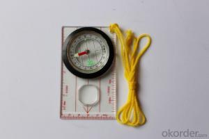
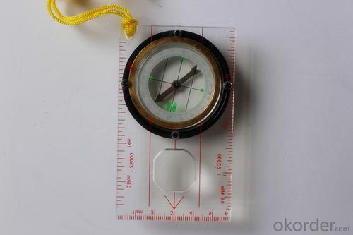


Transparant Map Scale Compass DC45-W
- Ref Price:
-

- Loading Port:
- China Main Port
- Payment Terms:
- TT OR LC
- Min Order Qty:
- -
- Supply Capability:
- -
OKorder Service Pledge
OKorder Financial Service
You Might Also Like


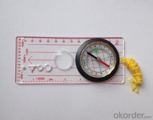
Model: DC45-5W
Name: Professional map compass, ruler compass
Product Origin: China
Supply Ability: 10,000 pcs/month
Minimum Order: 50 pcs
MOQ for OEM package: 500pcs
Product Size: 114*60.5*17 (mm)
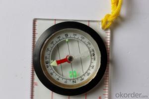
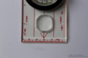
Features
1, professional usage: orientation, distance measuring, measuring slope, azimuth and pitching Angle measurement, drawing, a magnifying glass
2, high quality compass with neck rope, portable and rugged
3, ACRYLIC material, about 2mm thick
4, Damping Dial: to keep the stability of the pointer, more suitable for outdoor
environment.
5, Accuracy: accurate and clear, there were 360 degrees azimuth Angle, outer ring is 64-00 system, Liquid filled in the compass for reliable readings.
6, Magnifier function
- Q: What factors affect the handheld GPS receive signal?
- In addition to not see the sky (such as indoor, underground, dense forest) and narrow alleys and tall buildings on both sides of the environment, there will be no impact. Many GPS has 12 receivers (antenna unit), as long as it can capture 3 satellites can be three-dimensional positioning (including height), the 2 satellites can be flat positioning.
- Q: Handheld GPS navigation is what? Where to buy handheld GPS navigation, how to select GPS navigation?
- Handheld GPS navigator, also known as portable navigator, but also divided into 2 kinds, one is the ordinary PND navigator, you can go to Zhongguancun, the major appliance stores to buy, and the other is the mobile navigation, GPS smart phone is installed in the GPS navigation software can be,The navigator is composed of 2 parts: hardware and navigation software. The navigator on the market is about RMB 600. The brand of Kelid navigation software is usedGPS is a portable handheld navigation navigation products, the market is now very much, most car navigation can be used, the Gps signal is still free to receive satellite signals in the United States, you only need to charge it, map to the sellers in general can be upgraded.
- Q: How to set the handheld GPS related parameters and coordinate conversion parameters throughout the country
- Two. To coordinate the coordinate data of the control points obtained provide technical support unit of Beijing Unistrong companies around the branch responsible person to calculate the coordinate transformation parameters conversion parameters, or to obtain their own conversion conversion software. After the conversion parameters are calculated by the prompt input handheld GPS. Only after such a setup, after all the soil in the region when the coordinates of the GPS read out the coordinates of the point for the Beijing 54 coordinates.
- Q: Hand held GPS coordinate conversion method
- By the 84 coordinates to Beijing 54 Coordinate. A collection of application area of high grade control data in GPS receiver applied earth area (such as a county) find three (or more) uniform grade (accuracy better) or GPS "B" dot, point the best is around without interference of electromagnetic wave, vision, satellite signal. To the local surveying and mapping management department (such as: the local bureau of Surveying and mapping, surveying and Mapping Institute) Gauss plane coordinate copy these points of the Beijing 54 Coordinate System (x, y), the elevation of H and WGS-84 coordinates of the geodetic coordinates (B, L), the high H.
- Q: What is GPS Mu meter ah, with the general said that the GPS measuring instrument what is the difference?
- The amount of words on the handheld GPS, Magellan can be both economic and affordable.
- Q: Verify the accuracy of the GPS device to buy back, the way is to use Android under the'gps state 'software, to test the accuracy of real-time single point positioning.1 with two sets of the same Android Tablet Computer (custom machine, type of bad) in the same position for receiving, find that the accuracy is the same (software, are 1-2 meters), but the position would be poor 10 meters or more. It's in the same place.The 2 one is the Android tablet computer, a mobile phone is HTC G10, also received together in the same position, find that the accuracy is not the same as (the latter 20 meters or so), but also may be about 10 meters position difference.The accuracy of this GPS device can reach 1-2 meters, while the same location in real-time single point positioning error of 10 meters, a reasonable explanation.
- Oh, together with the exchange of learning, mutual verification, I said that is my experience. Software tells you that the accuracy is handled and limited, especially for some third party software. If you do not limit the scope of the conditions, the limit is too difficult to determine. If the satellite in poor condition, serious occlusion, satellite time difference, let alone ten meters, a few dozen a hundred meters are possible. Under normal circumstances, single point positioning accuracy is about ten meters, of course, sometimes all aspects of the conditions are very good, a few meters are also some. As for the accuracy of the GPS that you say htc10 and tablet computer, to this kind of navigation type GPS, from the respect of the respect that the instrument says, the accuracy should be in 10 meters to 15 meters (all the conditions are all right). Oh exchange!
- Q: What is the difference between a hand-held GPS and a car's onboard navigator
- As the first floor of a friend to answer the same, the general application of hand-held devices in land surveying, mountain climbing and other precise positioning when measuring the use of. Long standby time, three good performance. Easy to carry. A single charge can be used for a long time (depending on the machine). Although navigation, but the map is not detailed. At the same time, there is an opportunity to have latitude, latitude and other information.The car navigation is designed for users to drive out, in the field when not familiar with the road, ah, not familiar with the surrounding buildings, such as parking, hospitals, restaurants, gas stations. Used. Map details. But does not provide information such as latitude accuracy. No elevation.Look what you're doing. There is also a mobile phone navigation function.If you are purely for entertainment, then choose the phone.If you want to navigate in the car, select the vehicle navigation.If you are a very professional outdoor sports enthusiasts on the choice of handheld.
- Q: Handheld GPS charge is not into electricity what is the reason
- 3, restore the factory settings to see whether the system is.4, the battery damage, can replace the battery repair.
- Q: I am a handheld GPS precision is low, how to use to be able to improve certain accuracy
- If the carrier phase measurement function is not available, you have the maximum accuracy of GPS accuracy of 1-10This can only improve the observation environment using SBAS and other ways to improve the accuracy
- Q: What qualifications should a normal GPS locator have?
- Patent, business licenseLook what kind of
Send your message to us
Transparant Map Scale Compass DC45-W
- Ref Price:
-
- Loading Port:
- China Main Port
- Payment Terms:
- TT OR LC
- Min Order Qty:
- -
- Supply Capability:
- -
OKorder Service Pledge
OKorder Financial Service
Similar products


Hot products


Hot Searches
Related keywords

