


Rugged Ruler Mini-Compass DC45-6A for Surveying
- Ref Price:
-

- Loading Port:
- Tianjin
- Payment Terms:
- TT OR LC
- Min Order Qty:
- 20 pc
- Supply Capability:
- 10000 pc/month
OKorder Service Pledge
OKorder Financial Service
You Might Also Like


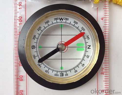
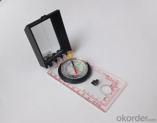
Model: DC45-6A
Name: Professional map compass, ruler compass
Product Origin: China
Supply Ability: 10,000 pcs/month
Minimum Order: 20 pcs
MOQ for OEM package: 500pcs
Product Size: 122*64*22 (mm)
Features of DC45-6A
1, professional usage: orientation, distance measuring, measuring slope, azimuth and pitching Angle measurement, drawing, a magnifying glass
2, high quality compass with neck rope, portable and rugged
3, ACRYLIC material, about 2mm thick
4, Damping Dial: to keep the stability of the pointer, more suitable for outdoor environment.
5, Accuracy: accurate and clear, there were 360 degrees azimuth Angle, outer ring is 64-00 system, Liquid filled in the compass for reliable readings.
6, Magnifier function
5,ruler compass,
6,for map measure and drawing
7,one meter neck rope,
8,Liquid filled in the compass for reliable readings,
9, magnifier function.
10,night vision map compass
- Q: Handheld GPS how to achieve decimeter
- "Shaanxi skmax navigation information Limited" GARMIN proxy (GARMIN official website can be found), contact (Xiao Hou) the hope can help to you, if you do not understand what we see on the Internet, may at any time, contact us
- Q: Can you buy a good handheld GPS in China? FiveTrouble master recommended several professional handheld GPS brand, in addition to handheld GPS can speed it? Thank you!!
- If it is used, there is no difference.
- Q: My friend is in use, the difference is not big, professional handset (smart or Magellan bulky, but 3 case), but the price is expensive, but can not call and map is very rotten, endurance of 10 hours (dry battery) the mobile phone also has all the time. Know friends say, I mainly in the suburbs! Thanks
- Three, the map of the differenceIn terms of the difference between the two maps is relatively large, most of the hand-held machine using contour map, the city is only as a secondary auxiliary. The mobile map is just the opposite, very detailed description of the city streets.Refer toThere is no road for GPS routing calculation. Popular said, handheld GPS to do is to draw a straight line to the destination, to determine their own inflection point. Handheld GPS will tell you to the destination: distance, course, yaw distance and other information (a lot of parameters, you can choose to display). In addition, handheld GPS also has to add a new landmark, through the software to draw their own waypoints, the average position of the measurement function, and even can measure the height and temperature, highlighting the degree of professionalism of its application.Cell phone navigation is very different from the former. GPS will be in accordance with the routing algorithm to calculate the nearest path, the premise is to have a detailed street map. GPS will tell you the right to turn right at the intersection. Mobile GPS can also search the starting point near the point of interest information, and can calculate the fastest path to reach the land.
- Q: Is it accurate to measure highway mileage with GPS handheld
- Measuring mileage, since the unit has been upgraded to the inside, it is quite accurate oh
- Q: I am ready to go to the field to go to college, but I do not know how to buy a handheld GPS, I hope you recommend. The most important thing is easy to carry.
- Is not a professional geography or geological personnel, there is no need to use Garmin ah Magellan what ah, you do not need. Using a mobile phone that can accept GPS signals is enough, free software and maps can be found on the internet. On the market a lot of 2000 yuan or so of the phone has this feature, remember that the phone has GPS signal acceptance, not GPRS oh!
- Q: How to set the handheld GPS related parameters and coordinate conversion parameters throughout the country
- Three parameter test DX, DY, DZ, DA, DF after the conversion parameters of the five, must be prompted to enter the handheld GPS, while the input area of the central meridian longitude. E on behalf of the east longitude, projection ratio of 1, the deviation of things to the north and south of the deviation of 0, and set the unit for M. Enter these parameters, should be taken to the field test, check whether these five parameters are correct. The method is selected, vision, GPS receiving signal strength of the feature points in the field (such as linear object intersections, independent features, etc.) is the best stone control points were measured and compared with theory and find out the coordinates of these points. If the results of the comparison exceed the nominal accuracy of the instrument, the conversion parameters or the problems that should be found should be recalculated.
- Q: I bought the way k20s, this handheld GPS how
- Choi way handheld GPS feel that you can also be in the last year, the Zhengzhou Bureau of Surveying and mapping seems to be called the wide Han instrument that home to buy, so there is no problem with it, the price is not expensive.
- Q: I am a handheld GPS precision is low, how to use to be able to improve certain accuracy.
- If the carrier phase measurement function is not available, you have the maximum accuracy of GPS accuracy of 1-10This can only improve the observation environment using SBAS and other ways to improve the accuracy
- Q: My cell phone: HTC Hero 200Question type: Internet softwareMy work needs to locate, record, output, and input GPS coordinates. Track record measurement, coordinate transformation. So would you have a professional security software under the table, so go out with a mobile phone or a PAD, or N equipment back to survey the tired,
- Taobao to enter the online shopping, mobile phone navigator on the line, I suggest you download the Careland navigation map, or tiger map
- Q: Handheld GPS each brand has what difference; different price difference in where is the positioning accuracy is different or what function is not the same?What are the differences between the measurements and the cars?
- Engage in measurement and what is the difference between the car I do not know, look at the car to see if the functionSMS + Mobile Internet + computer network platform! 3 ways to check the car!
Send your message to us
Rugged Ruler Mini-Compass DC45-6A for Surveying
- Ref Price:
-
- Loading Port:
- Tianjin
- Payment Terms:
- TT OR LC
- Min Order Qty:
- 20 pc
- Supply Capability:
- 10000 pc/month
OKorder Service Pledge
OKorder Financial Service
Similar products

Hot products


Hot Searches

