


Professional Map Scale Compass with Ruler
- Ref Price:
-

- Loading Port:
- Tianjin
- Payment Terms:
- TT OR LC
- Min Order Qty:
- 50 pc
- Supply Capability:
- 10000 pc/month
OKorder Service Pledge
OKorder Financial Service
You Might Also Like


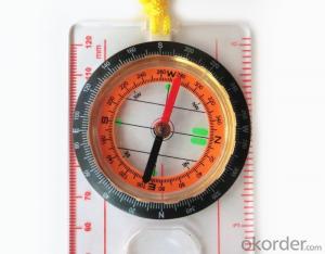
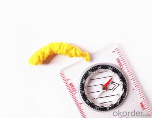
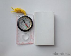
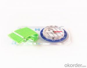
Structure of of Map Scale Compass Discription:
Model: DC45-5C
Name: Professional map compass, ruler compass
Product Origin: China
Supply Ability: 10,000 pcs/month
Minimum Order: 50 pcs
MOQ for OEM package: 500pcs
Main Features of Map Scale Compass:
1, professional usage: orientation, distance measuring, measuring slope, azimuth and pitching Angle measurement, drawing, a magnifying glass;
2, high quality compass with neck rope, portable and rugged;
3, ACRYLIC material, about 2mm thick;
4, Damping Dial: to keep the stability of the pointer, more suitable for outdoor environment;
5, Accuracy: accurate and clear, there were 360 degrees azimuth Angle, outer ring is 64-00 system, Liquid filled in the compass for reliable readings;
6, Magnifier function;
5, with ruler on compass DC45-5C;
6,for map measure and drawing;
7,one meter neck rope;
8,Liquid filled in the compass for reliable readings;
9, magnifier function;
10,night vision map compass;
11, Support OEM
Map Scale Compass Images:


Map Scale Compass Specification:
Product Size: 128*60*16(mm)
Color: OEM
FAQ of Map Scale Compass:
1,What is the warranty for this product?
3 months after receiving the device.
2,How long could we get the goods?
Within one week after payment, the product will be sent out.
3,Do you have service centers abroad?
No.The service centers are in China at present.
- Q: Handheld GPS how to achieve decimeter
- "Shaanxi skmax navigation information Limited" GARMIN proxy (GARMIN official website can be found), contact (Xiao Hou) the hope can help to you, if you do not understand what we see on the Internet, may at any time, contact us
- Q: How to set the handheld GPS related parameters and coordinate conversion parameters throughout the country
- Three parameter test DX, DY, DZ, DA, DF after the conversion parameters of the five, must be prompted to enter the handheld GPS, while the input area of the central meridian longitude. E on behalf of the east longitude, projection ratio of 1, the deviation of things to the north and south of the deviation of 0, and set the unit for M. Enter these parameters, should be taken to the field test, check whether these five parameters are correct. The method is selected, vision, GPS receiving signal strength of the feature points in the field (such as linear object intersections, independent features, etc.) is the best stone control points were measured and compared with theory and find out the coordinates of these points. If the results of the comparison exceed the nominal accuracy of the instrument, the conversion parameters or the problems that should be found should be recalculated.
- Q: Mobile GPS can replace professional handheld GPS
- Ziphah measured Mu instrument, a key measurement area, the use of simple, SV-118, with high precision imported GPS module and antenna, accurate measurement, the block walk in a circle to measure the size and graphics trajectory, 550 yuan, USB charging, large capacity lithium battery, black and white screen to see the clear day for outdoor use.
- Q: Handheld GPS which brand is good
- Now GPS can also do handheld measurement accuracy, precision can usually reach decimeter level, the industry there are relatively well-known Huace, professional GPS measurement instrument, high precision of handheld GPS the good.
- Q: The navigation module it is "selph" three generation? Another one I mainly use it to measure the land area, easy to use, the error is not big?I want to buy Magellan 500 do not know whether it is good to use
- Professional handheld GPS only Magellan and set SIBAO
- Q: How to hand GPS eTrex H data to the computer
- "Shaanxi skmax navigation information Limited" GARMIN proxy (GARMIN official website can be found), contact (Xiao Hou) the hope can help to you, if you do not understand what we see on the Internet, may at any time, contact us!
- Q: I just bought a handheld GPS Magellan No. 1, showing the latitude and longitude coordinates, I want to set the geodetic coordinates of latitude and longitude, do not know where to set, I would like to ask you, how to set, there is a better picture shows the best, thank you so much.Magellan GPS 210 is not 2000 shy
- 1 position: [format setting unit - "[] position display format is set to User UTM Grid, and enter the relevant parameters, such as the 3 degree or 6 degree with the area with the central meridian projection, the ratio was 1, that deviation is 500000m, north-south deviation is 0.2 map reference setting: [[map] - unit "benchmark is set to User, and input the DX, DY, DZ, DA, DF parameters, usually DX, DY, DZ vary from region to region, so need to know the high level control points to solve, solving methods are as follows:The handheld GPS is placed in the control point field buried pile, were measured, and then hand coordinate coordinates and the known control points of the GPS measurements obtained for the poor, can be obtained by local coordinates and elevation deviation value: DX, DY, DZ.
- Q: Ask how to select a google satellite map into a handheld Area GPS
- The ordinary mobile phone GPS, can install Orville interactive map support pre download any regional satellite map, support for offline use
- Q: Handheld GPS each brand has what difference; different price difference in where is the positioning accuracy is different or what function is not the same?What are the differences between the measurements and the cars?
- I was engaged in car GPS positioning, the first difference between different prices is the biggest cost of different module determines the price, this is the precise positioning of the key, but also the guarantee of product quality, rather than low-cost copycat version, as a kind of different price mobile phone, why Apple four generation sell so expensive but, only a few hundred to copycat.
- Q: What is the difference between professional navigation and professional GPS navigator
- 3 map software is accurate, you can identify the road on the viaduct, and you can tip up and down viaduct."This should be no problem currently on the market of the navigation software is mainly three: Skywalker, Kai Lide, cityonmap. Three navigation software has its own advantages and disadvantages. I personally feel that the person with Skywalker more, some car navigation systems (non open operating system) OEM software with Kay more than cityonmap map Skywalker is better but the interface is not good.4 mobile phone PDA load or other independent GPS devices can be.
Send your message to us
Professional Map Scale Compass with Ruler
- Ref Price:
-
- Loading Port:
- Tianjin
- Payment Terms:
- TT OR LC
- Min Order Qty:
- 50 pc
- Supply Capability:
- 10000 pc/month
OKorder Service Pledge
OKorder Financial Service
Similar products


Hot products


Hot Searches
Related keywords

