
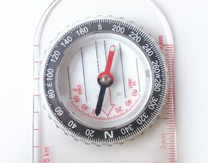

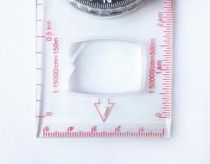
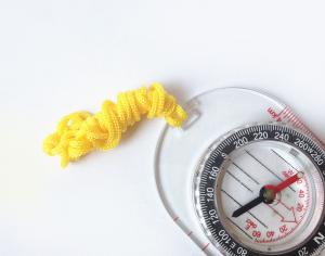


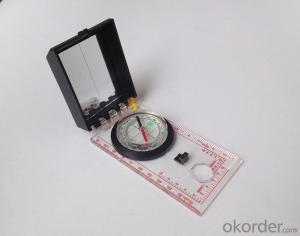
Acrylic Map compass DC47-2
- Ref Price:
-

- Loading Port:
- Tianjin
- Payment Terms:
- TT OR LC
- Min Order Qty:
- -
- Supply Capability:
- 5000 pc/month
OKorder Service Pledge
OKorder Financial Service
You Might Also Like


Product details
Model: DC47-2
Name: Professional map compass, ruler compass
Product Origin: China
Supply Ability: 10,000 pcs/month
Minimum Order: 50 pcs
MOQ for OEM package: 500pcs
Product Size: 115*55*11 (mm)
Color: OEM
Features
1, professional usage: orientation, distance measuring, measuring slope, azimuth and pitching Angle measurement, drawing, a magnifying glass
2, high quality compass with neck rope, portable and rugged
3, ACRYLIC material, about 2mm thick
4, Damping Dial: to keep the stability of the pointer, more suitable for outdoor
environment.
5, Accuracy: accurate and clear, there were 360 degrees azimuth Angle, outer ring is 64-00 system, Liquid filled in the compass for reliable readings.
6, Magnifier function
- Q: Handheld GPS positioning, can be directly uploaded to the computer, and the computer has a scalable map to mark the upload point. The above system, now there are 20Such as the title, I want to achieve the final function: through the manual to a point, with a hand-held GPS locator will be recorded in the specific latitude and longitude, and sent to the network in real time, for my computer to mark these points on the map. If you can directly enter the site of some of the information, directly to the above is the bestIf you have the above equipment, please indicate the scientific name, and the specific application industry.Thanks.
- 13 support GPS satellite positioning function, the need to connect GPS satellite positioning hardware devices (USB GPS devices or Bluetooth GPS devices; tablet PC).14 support offline map pack custom download function, you can download the map anywhere in the world.
- Q: GPS Mu meter which brand is good, handheld high-precision land area measuring instrument
- Simple operation, the screen is large, a few buttonsBoot, and then look at the star almost, to find a field, start and then click on the end of a circle, out of the number ofElectricity can alsoPrecision mody... With a special RTK or not, but what is sure to measure a circleFlat measurement of quasi accurate, biased on what is almost, it can be accepted
- Q: My friend is in use, the difference is not big, professional handset (smart or Magellan bulky, but 3 case), but the price is expensive, but can not call and map is very rotten, endurance of 10 hours (dry battery) the mobile phone also has all the time. Know friends say, I mainly in the suburbs! Thanks
- Professional GPS is mainly used for acquisition, is not used for navigation; of course, some professional GPS can install third party software, the accuracy is higher than the phone, this is positive;Mobile navigation is only used for navigation, navigation, path analysis and navigation functions, not the acquisition of maps of the instrument.
- Q: What is the difference between industrial GPS handset and mobile navigation
- 5, strong battery life, is a major feature of professional GPS, Garmin handset General of dry batteries can be used more than ten hours, while the mobile phone GPS on GPS also can use a few hours, if you open the GPS in general about 3 hours will be over.6, supporting different software. Professional GPS handheld opportunities related to the PC end of the data processing software, this software can achieve the acquisition of data processing, as well as the application of data collection. The phone GPS can only navigation, and navigation is only a small part of the GPS function.I simply say these, this is my personal summary of the difference, if you have what is not clear can exchange. Want to help you.
- Q: Hand held GPS coordinate conversion method
- Two. To coordinate the coordinate data of the control points obtained provide technical support unit of Beijing Unistrong companies around the branch responsible person to calculate the coordinate transformation parameters conversion parameters, or to obtain their own conversion conversion software. After the conversion parameters are calculated by the prompt input handheld GPS. Only after such a setup, after all the soil in the region when the coordinates of the GPS read out the coordinates of the point for the Beijing 54 coordinates.
- Q: What is GPS Mu meter ah, with the general said that the GPS measuring instrument what is the difference?
- If it's just a GPS meter and a GPS meter, that's a thing.If the measuring instrument, it is not the same with the measured mu instrument.In fact, these GPS is actually said handheld gps.It is used in measuring area and used in agriculture, forestry and animal husbandry.Handheld GPS generally have the function of measuring area.For example, Magellan, Gao Tianxiang handheld GPS etc. These are very famous, each model has the function of measuring areaWe have some stores!
- Q: Handheld GPS which brand is good
- Now GPS can also do handheld measurement accuracy, precision can usually reach decimeter level, the industry there are relatively well-known Huace, professional GPS measurement instrument, high precision of handheld GPS the good.
- Q: How to use the handheld GPS whole watershed investigation
- Therefore, it is an important method to solve the maximum value in physics by solving the maximum and minimum values of the physical quantity by the critical state.
- Q: Saying that we have a project in front of it is to do so, it is surprising that there are wood
- It is really unexpected, basically not, the accuracy is not enough!
- Q: How the German born handheld GPS Mu meter, I want to buy?
- Ergonomic design of lightweight and flexible dynamic appearance collocation black shell, the rear panel detector specially equipped with lights, emergency lights, more appropriate and practical, are small and easy to carry, dustproof, seismic, high temperature resistant, high capacity lithium battery long time power supply, full compliance with the harsh working environment.
Send your message to us
Acrylic Map compass DC47-2
- Ref Price:
-
- Loading Port:
- Tianjin
- Payment Terms:
- TT OR LC
- Min Order Qty:
- -
- Supply Capability:
- 5000 pc/month
OKorder Service Pledge
OKorder Financial Service
Similar products


Hot products


Hot Searches

