


Map Scale Compass DC47-2 with Ruler
- Ref Price:
-

- Loading Port:
- China Main Port
- Payment Terms:
- TT OR LC
- Min Order Qty:
- -
- Supply Capability:
- -
OKorder Service Pledge
OKorder Financial Service
You Might Also Like


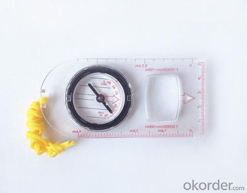
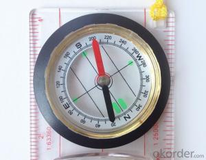
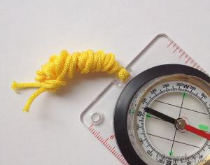
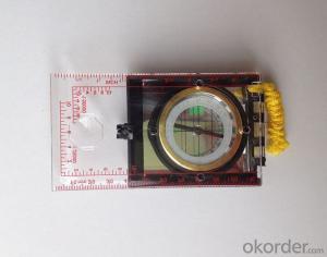
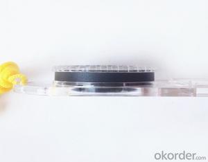
Model: DC47-2
Name: Professional map compass, ruler compass
Product Origin: China
Supply Ability: 10,000 pcs/month
Minimum Order: 50 pcs
MOQ for OEM package: 500pcs
Product Size: 115*55*11 (mm)
Features
1, professional usage: orientation, distance measuring, measuring slope, azimuth and pitching Angle measurement, drawing, a magnifying glass
2, high quality compass with neck rope, portable and rugged
3, ACRYLIC material, about 2mm thick
4, Damping Dial: to keep the stability of the pointer, more suitable for outdoor
environment.
5, Accuracy: accurate and clear, there were 360 degrees azimuth Angle, outer ring is 64-00 system, Liquid filled in the compass for reliable readings.
Payment term: TT/ LC
- Q: What factors affect the handheld GPS receive signal?
- The United States Department of defense. A SA satellite signal to interference (the U.S. government for consideration of security of civil code of a called "selective availability (Selective SA Availability)" interference, to ensure the best protection system is effective. Because of the random error information added by SA in the navigation message, the positioning accuracy of the civil signal C/A code is reduced to about 100 meters. However, the use of differential GPS technology, the system error can be reduced to 10 to 15 metersTwo. Weather factors (including sunspots, bad weather, etc.) to reduce the intensity of the received signalThree. In buildings, vehicles, insulation paper, or metal shielding, GPS signal will be reduced or completely lost signal. In open spaces, GPS devices receive the best signal. .
- Q: Handheld GPS buried in the soil there is a signal
- It depends on how deep you buried the darker the GPS signal, and must ensure that the GPS antenna upward, the above can not be covered with metal objects
- Q: Handheld GPS navigation is what? Where to buy handheld GPS navigation, how to select GPS navigation?
- Handheld GPS is mainly for GIS data acquisition, a lot of advanced GPS with PDA function, you can load navigation software for vehicle navigationBut the handheld GPS is mainly to do some engineering design, the main area can be measured, the location, and the boundary survey. GPS can do advanced vehicle navigation can also waypoint navigation, is a coordinate input to precise navigation to this position.Handheld GPS navigation is divided into 2 kinds, one is portable GPS navigation, one is used for surveying and mapping professional GPS handheld
- Q: Can a handheld navigator connect a cell phone? Thank you
- Mobile navigator can downloadOther purchases can not beNow basically use the phoneEasy update and operation
- Q: Mountaineering to buy a professional GPS or Mountaineering Watch
- There is no need to buy too many devices. Now the phone is an essential tool, the phone has GPS,
- Q: Hand held GPS coordinate conversion method
- By the 84 coordinates to Beijing 54 Coordinate. A collection of application area of high grade control data in GPS receiver applied earth area (such as a county) find three (or more) uniform grade (accuracy better) or GPS "B" dot, point the best is around without interference of electromagnetic wave, vision, satellite signal. To the local surveying and mapping management department (such as: the local bureau of Surveying and mapping, surveying and Mapping Institute) Gauss plane coordinate copy these points of the Beijing 54 Coordinate System (x, y), the elevation of H and WGS-84 coordinates of the geodetic coordinates (B, L), the high H.
- Q: Handheld GPS brand rankings
- SIBAOIn the GNSS coordinate precision and attributes, "SIBAO" has a professional GPS handset, GIS i-PPP GIS, a mobile data collector, GIS, high precision GIS, high precision measurement of RTK complete product structure, to form a comprehensive solution to the spatial information industry scheme. Set of SIBAO products awarded the Beijing independent innovation product identification certificate, satellite navigation and Engineering Excellence Award and other professional awards. At the time, location, navigation and other comprehensive applications, Unistrong successful implementation of hundreds of large projects, services in many national key projects, won the national honor.MagellanGarmin
- Q: Mobile GPS can replace professional handheld GPS
- Ziphah measured Mu instrument, a key measurement area, the use of simple, SV-118, with high precision imported GPS module and antenna, accurate measurement, the block walk in a circle to measure the size and graphics trajectory, 550 yuan, USB charging, large capacity lithium battery, black and white screen to see the clear day for outdoor use.
- Q: Saying that we have a project in front of it is to do so, it is surprising that there are wood
- Hello friends, so, do 1:2000 topographic mapping with a handheld GPS is obviously not reality, after all, the handheld GPS precision is, however, now we are in the handheld equipment is no GPS, in fact, in the absence of the base station is a handheld GPS, receiving SBAS difference can reach sub meter level, but if a base station or receive CROS network differential signal will be RTK mobile station,
- Q: Handheld GPS, the measurement of arable land, fixed point and circle test, which is more accurate,
- So for you to measure the area, some of the 3cm point error surrounded by the graphics area and some millimeter level point error surrounded by the graphics area is not much difference.
Send your message to us
Map Scale Compass DC47-2 with Ruler
- Ref Price:
-
- Loading Port:
- China Main Port
- Payment Terms:
- TT OR LC
- Min Order Qty:
- -
- Supply Capability:
- -
OKorder Service Pledge
OKorder Financial Service
Similar products
Hot products


Hot Searches
Related keywords

