


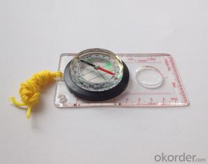
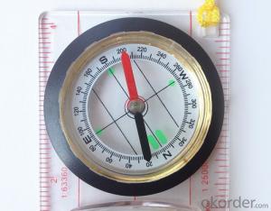
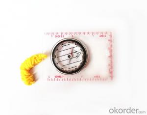
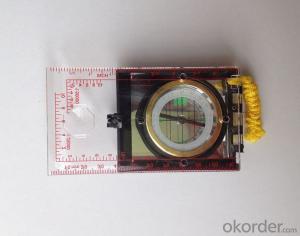
Map Scale or Ruler Compass DC45-5A
- Ref Price:
-

- Loading Port:
- China Main Port
- Payment Terms:
- TT OR LC
- Min Order Qty:
- -
- Supply Capability:
- -
OKorder Service Pledge
OKorder Financial Service
You Might Also Like


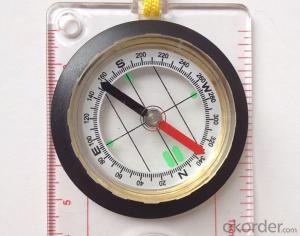
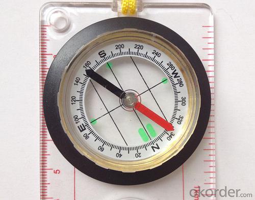
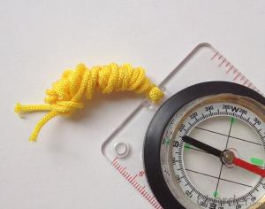
Model: DC45-5A
Name: Professional map compass, ruler compass
Product Origin: China
Supply Ability: 10,000 pcs/month
Minimum Order: 50 pcs
MOQ for OEM package: 500pcs
Product Size: 108*61*16 (mm)
Features
1, professional usage: orientation, distance measuring, measuring slope, azimuth and pitching Angle measurement, drawing, a magnifying glass
2, high quality compass with neck rope, portable and rugged
3, ACRYLIC material, about 2mm thick
4, Damping Dial: to keep the stability of the pointer, more suitable for outdoor
environment.
5, Accuracy: accurate and clear, there were 360 degrees azimuth Angle, outer ring is 64-00 system, Liquid filled in the compass for reliable readings.
Payment term: TT/ LC
- Q: What factors affect the handheld GPS receive signal?
- The hand-held GPS is generally accepted the satellite signal, a sheltered place will affect the signal delivery in different range of handset with method, sometimes, because of the incorrect operation, the human body is one of the obstacles
- Q: Handheld GPS how to achieve decimeter
- "Shaanxi skmax navigation information Limited" GARMIN proxy (GARMIN official website can be found), contact (Xiao Hou) the hope can help to you, if you do not understand what we see on the Internet, may at any time, contact us
- Q: Handheld GPS navigation is what? Where to buy handheld GPS navigation, how to select GPS navigation?
- Select the main consideration of the following issues on the line:1, GPS receiving capacity, in the interior, the streets can be measured on a few stars, while looking at the speed of the search star? If a place for 2 - 3 minutes accurate positioning can be used2, the map is the latest, often used to check those routes3, battery life is how long to ask4, accessories, such as support, car charge, the size of the memory card should be clearly presentedThe location of the purchase is usually in the car decoration department or the electronic mall or digital products store salesAffordable mall can look at the old brand, operating for many years, where I bought the electronic dog
- Q: Professional handheld GPS GARMIN (DR) how to use
- Handheld GPS purposes, the measurement of soil area, linear navigation, auxiliary fishing waypoint navigation point information, traffic data display, such as the use of functional machines should be used manual
- Q: Handheld GPS which brand is good
- Now GPS can also do handheld measurement accuracy, precision can usually reach decimeter level, the industry there are relatively well-known Huace, professional GPS measurement instrument, high precision of handheld GPS the good.
- Q: Fuxin coordinates with the mapping of the seven parameters are what ah there is no professional knowledge to tell my brother I need to fill the gps... Thanks.
- Three translation parameters Delta X, Delta Y, Delta Z, three rotation parameter w X, Omega Y, Omega Z and a zoom M, these parameters need to be calculated in a fixed point under different ellipsoid!
- Q: Magellan GPS handheld why so many people choose not to say that the map is not good
- Magellan GPS handheld maps are not even, it is said that the map even money! No need ah.
- Q: I just bought a handheld GPS Magellan No. 1, showing the latitude and longitude coordinates, I want to set the geodetic coordinates of latitude and longitude, do not know where to set, I would like to ask you, how to set, there is a better picture shows the best, thank you so much.Magellan GPS 210 is not 2000 shy
- 1 position: [format setting unit - "[] position display format is set to User UTM Grid, and enter the relevant parameters, such as the 3 degree or 6 degree with the area with the central meridian projection, the ratio was 1, that deviation is 500000m, north-south deviation is 0.2 map reference setting: [[map] - unit "benchmark is set to User, and input the DX, DY, DZ, DA, DF parameters, usually DX, DY, DZ vary from region to region, so need to know the high level control points to solve, solving methods are as follows:The handheld GPS is placed in the control point field buried pile, were measured, and then hand coordinate coordinates and the known control points of the GPS measurements obtained for the poor, can be obtained by local coordinates and elevation deviation value: DX, DY, DZ.
- Q: How to upgrade handheld navigator
- Some 4S shop can;Read the instructions, there are generally USB mouth, then you can upgrade the computer practice;There is a memory card, then you can remove the plug on the computer upgrade;Or get the computer city to see it.
- Q: Handheld GPS purchaseHandheld GPS navigator!Is mainly used for tourism, I said is not a mobile phone, is a more professional handheld GPS navigator for travel outside! Handheld GPS navigator can voice navigation?
- The more high-end is good, clever and wheat zalun, many outdoor enthusiasts are used to this, hiking, cycling and other applications are relatively wide, is an American brand, Mazelen returned to the U.S. Army GPS, and as Ma Ying-Jeou ring when riding on the handlebar also puts a high out of this two 60CSX. the brand in the nature, the price is more expensive, in more than 2000, but the best is to the store to buy.
Send your message to us
Map Scale or Ruler Compass DC45-5A
- Ref Price:
-
- Loading Port:
- China Main Port
- Payment Terms:
- TT OR LC
- Min Order Qty:
- -
- Supply Capability:
- -
OKorder Service Pledge
OKorder Financial Service
Similar products

Hot products


Hot Searches
Related keywords

