


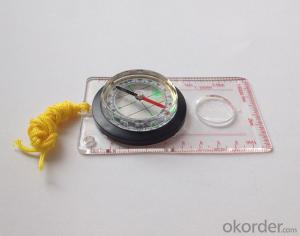
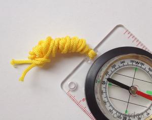
Map Scale Compass DC45-5W
- Ref Price:
-

- Loading Port:
- China Main Port
- Payment Terms:
- TT OR LC
- Min Order Qty:
- -
- Supply Capability:
- -
OKorder Service Pledge
OKorder Financial Service
You Might Also Like


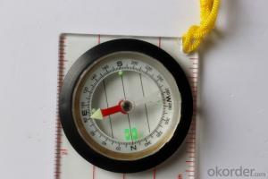
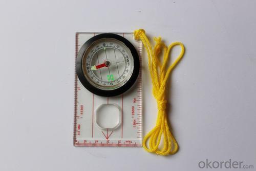
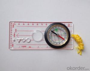
Model: DC45-5W
Name: Professional map compass, ruler compass
Product Origin: China
Supply Ability: 10,000 pcs/month
Minimum Order: 50 pcs
MOQ for OEM package: 500pcs
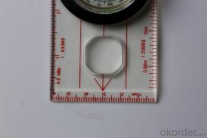
Product Size: 114*60.5*17 (mm)
Features
1, professional usage: orientation, distance measuring, measuring slope, azimuth and pitching Angle measurement, drawing, a magnifying glass
2, high quality compass with neck rope, portable and rugged
3, ACRYLIC material, about 2mm thick
4, Damping Dial: to keep the stability of the pointer, more suitable for outdoor
environment.
5, Accuracy: accurate and clear, there were 360 degrees azimuth Angle, outer ring is 64-00 system, Liquid filled in the compass for reliable readings.
Payment term: TT/ LC
- Q: What factors affect the handheld GPS receive signal?
- The hand-held GPS is generally accepted the satellite signal, a sheltered place will affect the signal delivery in different range of handset with method, sometimes, because of the incorrect operation, the human body is one of the obstacles
- Q: Handheld GPS need to put the phone card?
- Hello, now the general GPS are required to put the card! Thanks
- Q: My friend is in use, the difference is not big, professional handset (smart or Magellan bulky, but 3 case), but the price is expensive, but can not call and map is very rotten, endurance of 10 hours (dry battery) the mobile phone also has all the time. Know friends say, I mainly in the suburbs! Thanks
- Two, different hardware configurationAs the field work environment is relatively poor, so waterproof, dustproof, shockproof for handheld GPS is very necessary. Handheld GPS on the market level of water is generally IPX7, and the continuous use of time is often more than 10 hours. Mobile phones are not so much demand. Handheld GPS function is relatively simple, and even most of the products are still grayscale display screen, multimedia features almost No.In the chip, there is not much difference between the GPS and GPS handheld mobile phone, mobile phone is commonly used in the Samsung 2440 chip and SIRF III receiving module on the handset is also very common, but in recent years MSTAR from Taiwan due to its advantages of cheap, very popular in the low-end handset.
- Q: I am ready to go to the field to go to college, but I do not know how to buy a handheld GPS, I hope you recommend. The most important thing is easy to carry.
- Is not a professional geography or geological personnel, there is no need to use Garmin ah Magellan what ah, you do not need. Using a mobile phone that can accept GPS signals is enough, free software and maps can be found on the internet. On the market a lot of 2000 yuan or so of the phone has this feature, remember that the phone has GPS signal acceptance, not GPRS oh!
- Q: Handheld GPS navigation is what? Where to buy handheld GPS navigation, how to select GPS navigation?
- Select the main consideration of the following issues on the line:1, GPS receiving capacity, in the interior, the streets can be measured on a few stars, while looking at the speed of the search star? If a place for 2 - 3 minutes accurate positioning can be used2, the map is the latest, often used to check those routes3, battery life is how long to ask4, accessories, such as support, car charge, the size of the memory card should be clearly presentedThe location of the purchase is usually in the car decoration department or the electronic mall or digital products store salesAffordable mall can look at the old brand, operating for many years, where I bought the electronic dog
- Q: Seeking the similarities and differences between RTK and GPS
- RTK full name is GPS-RTK real-time dynamic distribution, which you know.
- Q: What is the difference between professional GPS handsets and mobile navigation?
- Mobile phones are used for network navigation, no network will not work, professional GPS navigation satellite navigation,
- Q: Mobile GPS can replace professional handheld GPS
- Ziphah measured Mu instrument, a key measurement area, the use of simple, SV-118, with high precision imported GPS module and antenna, accurate measurement, the block walk in a circle to measure the size and graphics trajectory, 550 yuan, USB charging, large capacity lithium battery, black and white screen to see the clear day for outdoor use.
- Q: Welcome to make comments on the existing GPS tour pal what shortcomings to answer the more detailed the better
- The first three factors: ability as a good tour pal, sun and rain fearless tramp over mountains and through ravines Rulvpingdi, GPS, his nature can not be weak, small knock a small touch can not have temper, off or out in the water dirty, also to be able to continue the work. So the waterproof / earthquake / dust and other indicators become the primary consideration factors GPS these are the protective ability of vehicle GPS, most of them do not have, and some professional GPS design, there will be more conducive to the harsh environment, such as some of the products designed to be capable of floating after falling into the water. The outdoor need to step back. What is it, if you can not do to prevent flooding, then rain proof ability is the minimum requirement.
- Q: Handheld GPS each brand has what difference; different price difference in where is the positioning accuracy is different or what function is not the same?What are the differences between the measurements and the cars?
- Engage in measurement and what is the difference between the car I do not know, look at the car to see if the functionSMS + Mobile Internet + computer network platform! 3 ways to check the car!
Send your message to us
Map Scale Compass DC45-5W
- Ref Price:
-
- Loading Port:
- China Main Port
- Payment Terms:
- TT OR LC
- Min Order Qty:
- -
- Supply Capability:
- -
OKorder Service Pledge
OKorder Financial Service
Similar products


Hot products


Hot Searches
Related keywords

