


Map Direction Compass DC40
- Ref Price:
-

- Loading Port:
- China Main Port
- Payment Terms:
- TT OR LC
- Min Order Qty:
- -
- Supply Capability:
- -
OKorder Service Pledge
OKorder Financial Service
You Might Also Like


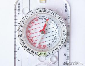
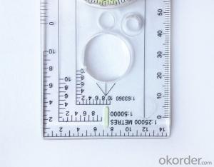
Model: DC40-3A
Name: Professional map compass, ruler compass
Product Origin: China
Supply Ability: 10,000 pcs/month
Minimum Order: 30 pcs
MOQ for OEM package: 500pcs
Material: Plastic
Features
1, professional usage: orientation, distance measuring, measuring slope, azimuth and pitching Angle measurement, drawing, a magnifying glass
2, high quality compass with neck rope, portable and rugged
3, ACRYLIC material, about 2mm thick
4, Damping Dial: to keep the stability of the pointer, more suitable for outdoor
environment.
5, Accuracy: accurate and clear, there were 360 degrees azimuth Angle, outer ring is 64-00 system, Liquid filled in the compass for reliable readings.
6, Magnifier function
- Q: GPS Mu meter which brand is good, handheld high-precision land area measuring instrument
- A German born mu can also recommend a good precision measuring instrument.
- Q: Seeking the similarities and differences between RTK and GPS
- RTK full name is GPS-RTK real-time dynamic distribution, which you know.
- Q: What is the difference between industrial GPS handset and mobile navigation
- I am a professional to do GPS, the difference between the professional handheld and mobile GPS is very understanding, here and your simple communication.1, GPS is the most important positioning accuracy and confidence. Professional handheld GPS chip used to stabilize the performance of some, the accuracy will be better, such as Garmin handheld high-end product positioning can be achieved within 3 meters, while the phone's GPS chip is different.2, both in the design and positioning of the crowd is very different. Professional GPS more focus on outdoor industry and users, the use of design idea is how to better outdoors, outdoor tourism including tourism exploration assistant very full function, and mobile phone GPS is a trend not only, what purpose.
- Q: I am a handheld GPS precision is low, how to use to be able to improve certain accuracy.
- If the carrier phase measurement function is not available, you have the maximum accuracy of GPS accuracy of 1-10This can only improve the observation environment using SBAS and other ways to improve the accuracy
- Q: Hand held GPS coordinate conversion method
- By the 84 coordinates to Beijing 54 Coordinate. A collection of application area of high grade control data in GPS receiver applied earth area (such as a county) find three (or more) uniform grade (accuracy better) or GPS "B" dot, point the best is around without interference of electromagnetic wave, vision, satellite signal. To the local surveying and mapping management department (such as: the local bureau of Surveying and mapping, surveying and Mapping Institute) Gauss plane coordinate copy these points of the Beijing 54 Coordinate System (x, y), the elevation of H and WGS-84 coordinates of the geodetic coordinates (B, L), the high H.
- Q: Handheld GPS brand rankings
- SIBAOIn the GNSS coordinate precision and attributes, "SIBAO" has a professional GPS handset, GIS i-PPP GIS, a mobile data collector, GIS, high precision GIS, high precision measurement of RTK complete product structure, to form a comprehensive solution to the spatial information industry scheme. Set of SIBAO products awarded the Beijing independent innovation product identification certificate, satellite navigation and Engineering Excellence Award and other professional awards. At the time, location, navigation and other comprehensive applications, Unistrong successful implementation of hundreds of large projects, services in many national key projects, won the national honor.MagellanGarmin
- Q: How to use the handheld GPS whole watershed investigation
- Some people think that the use of critical state to solve the most value should be cautious, we must first distinguish the relationship between the two states
- Q: Fuxin coordinates with the mapping of the seven parameters are what ah there is no professional knowledge to tell my brother I need to fill the gps... Thanks.
- Three translation parameters Delta X, Delta Y, Delta Z, three rotation parameter w X, Omega Y, Omega Z and a zoom M, these parameters need to be calculated in a fixed point under different ellipsoid!
- Q: Handheld GPS each brand has what difference; different price difference in where is the positioning accuracy is different or what function is not the same?What are the differences between the measurements and the cars?
- I was engaged in car GPS positioning, the first difference between different prices is the biggest cost of different module determines the price, this is the precise positioning of the key, but also the guarantee of product quality, rather than low-cost copycat version, as a kind of different price mobile phone, why Apple four generation sell so expensive but, only a few hundred to copycat.
- Q: What qualifications should a normal GPS locator have?
- Look at his company's business license is what's on the line, if the manufacturer has the most basic 3C proved, and some such as system certification or proof of what the explosion proof CEPREI
Send your message to us
Map Direction Compass DC40
- Ref Price:
-
- Loading Port:
- China Main Port
- Payment Terms:
- TT OR LC
- Min Order Qty:
- -
- Supply Capability:
- -
OKorder Service Pledge
OKorder Financial Service
Similar products


Hot products


Hot Searches

