


Good Mapor Ruler Mini-Compass DC47-2 for Surveying
- Ref Price:
-

- Loading Port:
- Tianjin
- Payment Terms:
- TT OR LC
- Min Order Qty:
- 20 pc
- Supply Capability:
- 10000 pc/month
OKorder Service Pledge
OKorder Financial Service
You Might Also Like


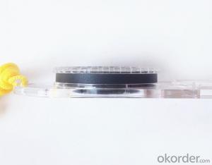
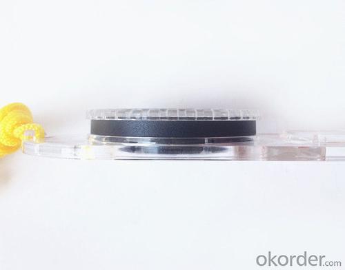
Model: DC47-2
Name: Professional map compass, ruler compass
Product Origin: China
Supply Ability: 10,000 pcs/month
Minimum Order: 20 pcs
MOQ for OEM package: 500pcs
Product Size: 125.5*60.5*10 (mm)
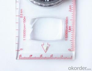
Features of DC47-2
1, professional usage: orientation, distance measuring, measuring slope, azimuth and pitching Angle measurement, drawing, a magnifying glass
2, high quality compass with neck rope, portable and rugged
3, ACRYLIC material, about 2mm thick
4, Damping Dial: to keep the stability of the pointer, more suitable for outdoor environment.
5, Accuracy: accurate and clear, there were 360 degrees azimuth Angle, outer ring is 64-00 system, Liquid filled in the compass for reliable readings.
6, Magnifier function
5,ruler compass,
6,for map measure and drawing
7,one meter neck rope,
8,Liquid filled in the compass for reliable readings,
9, magnifier function.
- Q: I would like to ask the GPS handset and GPS receiver (Surveying and mapping qualification application needs) is there a difference? If yes, what is the difference?
- This is the case, GPS handheld refers to a thin hand, while the GPS receiver refers to the RTK host, equivalent to the base station in our industry said. The general application of Surveying and mapping qualifications are required for this application, referred to as RTK (1+1) set, level, theodolite, total station, walkie talkie, technical personnel.... And so on, are essential equipment.
- Q: Handheld GPS need to put the phone card?
- Travel GPS professional solutions:Put card. Will be equipped with a card at the time of purchase.
- Q: I am ready to go to the field to go to college, but I do not know how to buy a handheld GPS, I hope you recommend. The most important thing is easy to carry.
- At present, the formal channels genuine licensed not so cheap, some refurbished machines may have. The cheapest machines now have about 900-1000!
- Q: Handheld GPS navigation is what? Where to buy handheld GPS navigation, how to select GPS navigation?
- Handheld GPS is mainly for GIS data acquisition, a lot of advanced GPS with PDA function, you can load navigation software for vehicle navigationBut the handheld GPS is mainly to do some engineering design, the main area can be measured, the location, and the boundary survey. GPS can do advanced vehicle navigation can also waypoint navigation, is a coordinate input to precise navigation to this position.Handheld GPS navigation is divided into 2 kinds, one is portable GPS navigation, one is used for surveying and mapping professional GPS handheld
- Q: Can a handheld navigator connect a cell phone? Thank you
- Mobile navigator can downloadOther purchases can not beNow basically use the phoneEasy update and operation
- Q: What is the difference between professional GPS handsets and mobile navigation?
- GPS is the most important positioning accuracy. Professional handheld machine with industrial design. First of all, if used outdoors, then fell, and so on are likely to water, and this thing is also very expensive, so the opportunity to have a high professional anti shock waterproof performance.
- Q: Mobile GPS can replace professional handheld GPS
- No, professional signal and positioning more accurate,Walk along the plots in a circle can measure the size and graphics trajectory, 550 yuan, USB charging, large capacity lithium battery, black and white screen to see the clear day for outdoor use.
- Q: Welcome to make comments on the existing GPS tour pal what shortcomings to answer the more detailed the better
- The first three factors: ability as a good tour pal, sun and rain fearless tramp over mountains and through ravines Rulvpingdi, GPS, his nature can not be weak, small knock a small touch can not have temper, off or out in the water dirty, also to be able to continue the work. So the waterproof / earthquake / dust and other indicators become the primary consideration factors GPS these are the protective ability of vehicle GPS, most of them do not have, and some professional GPS design, there will be more conducive to the harsh environment, such as some of the products designed to be capable of floating after falling into the water. The outdoor need to step back. What is it, if you can not do to prevent flooding, then rain proof ability is the minimum requirement.
- Q: The navigation module it is "selph" three generation? Another one I mainly use it to measure the land area, easy to use, the error is not big?I want to buy Magellan 500 do not know whether it is good to use
- A type specific.GPS chip area measurement is the most "selph" 3 generation, special machine is very good, the error is very small.
- Q: What is the difference between professional navigation and professional GPS navigator
- You can understand the principle of the radio transmitter receiver radio information, is not charged. GPS only in the need to track and special needs, and through the GSM network data is to receive GPRS traffic charges. Upgrade the main map of the general manufacturers do not charge. Now there are many kinds of vehicle navigation systems, different brands and various functions....Now we have to find a good brand navigation.....I hear people say it's a good way...A Thunis brand navigator is a hot productNow to the car navigator has a lot of MP3, MP4 and other entertainment features,,,,Fixed speed, movement speed and other functions....It is best to have a rear view, and, more secure.... GPS Car Navigator, simply said, is the navigator can help users to accurately locate the current position, and according to the established objective calculation of stroke by map display driving auxiliary equipment and voice prompt two ways to guide the user to the destination. It includes two important components: one is the global positioning system (Global Positioning System) referred to as GPSSuggest that you buy a professional GPS, after all, the phone's function is to call.
Send your message to us
Good Mapor Ruler Mini-Compass DC47-2 for Surveying
- Ref Price:
-
- Loading Port:
- Tianjin
- Payment Terms:
- TT OR LC
- Min Order Qty:
- 20 pc
- Supply Capability:
- 10000 pc/month
OKorder Service Pledge
OKorder Financial Service
Similar products


Hot products


Hot Searches

