


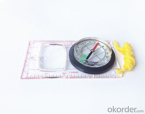


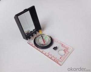
Good Mapor Ruler Mini-Compass DC45-B for Surveying
- Ref Price:
-

- Loading Port:
- Tianjin
- Payment Terms:
- TT OR LC
- Min Order Qty:
- 20 pc
- Supply Capability:
- 10000 pc/month
OKorder Service Pledge
OKorder Financial Service
You Might Also Like


Model: DC45-5B
Name: Professional map compass, ruler compass
Product Origin: China
Supply Ability: 10,000 pcs/month
Minimum Order: 20 pcs
MOQ for OEM package: 500pcs
Product Size: 112*62*17 (mm)
Features of DC45-5B
1, professional usage: orientation, distance measuring, measuring slope, azimuth and pitching Angle measurement, drawing, a magnifying glass
2, high quality compass with neck rope, portable and rugged
3, ACRYLIC material, about 2mm thick
4, Damping Dial: to keep the stability of the pointer, more suitable for outdoor environment.
5, Accuracy: accurate and clear, there were 360 degrees azimuth Angle, outer ring is 64-00 system, Liquid filled in the compass for reliable readings.
6, Magnifier function
5,ruler compass,
6,for map measure and drawing
7,one meter neck rope,
8,Liquid filled in the compass for reliable readings,
9, magnifier function.
- Q: What factors affect the handheld GPS receive signal?
- The United States Department of defense. A SA satellite signal to interference (the U.S. government for consideration of security of civil code of a called "selective availability (Selective SA Availability)" interference, to ensure the best protection system is effective. Because of the random error information added by SA in the navigation message, the positioning accuracy of the civil signal C/A code is reduced to about 100 meters. However, the use of differential GPS technology, the system error can be reduced to 10 to 15 metersTwo. Weather factors (including sunspots, bad weather, etc.) to reduce the intensity of the received signalThree. In buildings, vehicles, insulation paper, or metal shielding, GPS signal will be reduced or completely lost signal. In open spaces, GPS devices receive the best signal. .
- Q: Handheld GPS positioning, can be directly uploaded to the computer, and the computer has a scalable map to mark the upload point. The above system, now there are 20Such as the title, I want to achieve the final function: through the manual to a point, with a hand-held GPS locator will be recorded in the specific latitude and longitude, and sent to the network in real time, for my computer to mark these points on the map. If you can directly enter the site of some of the information, directly to the above is the bestIf you have the above equipment, please indicate the scientific name, and the specific application industry.Thanks.
- 4 support coordinate query positioning, you can enter the coordinates of the value of the location of the query.5 support user defined information, advanced information query, real-time positioning results.6 support for the selected annotations on the map.
- Q: Handheld GPS need to put the phone card?
- Hello, now the general GPS are required to put the card! Thanks
- Q: Can you buy a good handheld GPS in China? FiveTrouble master recommended several professional handheld GPS brand, in addition to handheld GPS can speed it? Thank you!!
- The main function is to use navigation as long as the navigation function can be used
- Q: Is it accurate to measure highway mileage with GPS handheld
- Measuring mileage, since the unit has been upgraded to the inside, it is quite accurate oh
- Q: Handheld GPS navigation is what? Where to buy handheld GPS navigation, how to select GPS navigation?
- Select the main consideration of the following issues on the line:1, GPS receiving capacity, in the interior, the streets can be measured on a few stars, while looking at the speed of the search star? If a place for 2 - 3 minutes accurate positioning can be used2, the map is the latest, often used to check those routes3, battery life is how long to ask4, accessories, such as support, car charge, the size of the memory card should be clearly presentedThe location of the purchase is usually in the car decoration department or the electronic mall or digital products store salesAffordable mall can look at the old brand, operating for many years, where I bought the electronic dog
- Q: I am a handheld GPS precision is low, how to use to be able to improve certain accuracy.
- Look at the maximum accuracy of GPSIf the difference accuracy can reach 1cm you can connect CORS single base station and other network RTK way to achieve the corresponding accuracy
- Q: How do I still stay in the GPS navigation, GPS monitoring of the primary idea? FiveBusiness services, thank you!Future business services
- Mainly for the ship, automobile, aircraft and other moving objects positioning navigation. For example:1 ocean navigation and incoming water diversion2 aircraft route guidance and approach landing3 vehicle autonomous navigation4 ground vehicle tracking and urban intelligent traffic management5 emergency rescue
- Q: Welcome to make comments on the existing GPS tour pal what shortcomings to answer the more detailed the better
- Fifth elements: the terrain map is the main project of outdoor sports climbing, mountain climbing is very exhausting, we usually do a plan will be completed on schedule, a good plan should be to our destination in the manual run out before. And if you want to do this, it must be on the road difficult to have a correct anticipation. But this time, with the terrain map GPS can come in handy, the mountains and the altitude of the understanding, we need to know about these sections spend much time and energy. And the general GPS map, is unable to meet the needs. So we'd better buy a map with contour terrain data of professional grade GPS, make your own outdoor journey do in our hands.
- Q: What do you need to test for GPS?
- 5.DGPS you know, differential GPS (DGPS) positioning accuracy is very high, some GPS equipment providers set up a DGPS transmitter in some areas, free of charge to its customers, if customers are buying GPS receivers with DGPS function. The DGPS transmitter is a fixed GPS receiver (in a 100km ~ 200km exploration scene in the radius setting) receive satellite signals, it knows exactly what is the exact time of transmitting satellite signal to the theory, and then compare it with the actual delivery time, then calculate the "difference", influence this is very close to the atmospheric refraction, it will send out the difference, usually with FM (FM) radio data transmission using subcarrier modulation signal in the baseband receiver, GPS and DGPS function can receive and use it more accurate positioning.
Send your message to us
Good Mapor Ruler Mini-Compass DC45-B for Surveying
- Ref Price:
-
- Loading Port:
- Tianjin
- Payment Terms:
- TT OR LC
- Min Order Qty:
- 20 pc
- Supply Capability:
- 10000 pc/month
OKorder Service Pledge
OKorder Financial Service
Similar products


Hot products


Hot Searches

