


Good Mapor Ruler Mini-Compass DC45-5D for Surveying
- Ref Price:
-

- Loading Port:
- Tianjin
- Payment Terms:
- TT OR LC
- Min Order Qty:
- 20 pc
- Supply Capability:
- 10000 pc/month
OKorder Service Pledge
OKorder Financial Service
You Might Also Like


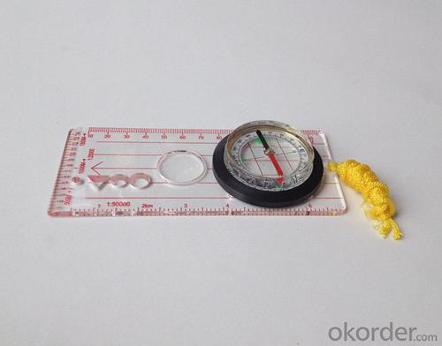
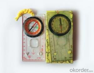
Model: DC45-5D
Name: Professional map compass, ruler compass
Product Origin: China
Supply Ability: 10,000 pcs/month
Minimum Order: 20 pcs
MOQ for OEM package: 500pcs
Product Size: 128*60*16 (mm)
Features of DC45-5D
1, professional usage: orientation, distance measuring, measuring slope, azimuth and pitching Angle measurement, drawing, a magnifying glass
2, high quality compass with neck rope, portable and rugged
3, ACRYLIC material, about 2mm thick
4, Damping Dial: to keep the stability of the pointer, more suitable for outdoor environment.
5, Accuracy: accurate and clear, there were 360 degrees azimuth Angle, outer ring is 64-00 system, Liquid filled in the compass for reliable readings.
6, Magnifier function
5,ruler compass,
6,for map measure and drawing
7,one meter neck rope,
8,Liquid filled in the compass for reliable readings,
9, magnifier function.
- Q: Can you buy a good handheld GPS in China? FiveTrouble master recommended several professional handheld GPS brand, in addition to handheld GPS can speed it? Thank you!!
- The main function is to use navigation as long as the navigation function can be used
- Q: Seeking the similarities and differences between RTK and GPS
- RTK full name is GPS-RTK real-time dynamic distribution, which you know.
- Q: I bought the way k20s, this handheld GPS how
- Ordinary hand-held GPS is 3-5 meter accuracy, high accuracy can be achieved unless buy submeter ordinary user, if you can.
- Q: I am a handheld GPS precision is low, how to use to be able to improve certain accuracy.
- Look at the maximum accuracy of GPSIf the difference accuracy can reach 1cm you can connect CORS single base station and other network RTK way to achieve the corresponding accuracy
- Q: Verify the accuracy of the GPS device to buy back, the way is to use Android under the'gps state 'software, to test the accuracy of real-time single point positioning.1 with two sets of the same Android Tablet Computer (custom machine, type of bad) in the same position for receiving, find that the accuracy is the same (software, are 1-2 meters), but the position would be poor 10 meters or more. It's in the same place.The 2 one is the Android tablet computer, a mobile phone is HTC G10, also received together in the same position, find that the accuracy is not the same as (the latter 20 meters or so), but also may be about 10 meters position difference.The accuracy of this GPS device can reach 1-2 meters, while the same location in real-time single point positioning error of 10 meters, a reasonable explanation.
- Oh, together with the exchange of learning, mutual verification, I said that is my experience. Software tells you that the accuracy is handled and limited, especially for some third party software. If you do not limit the scope of the conditions, the limit is too difficult to determine. If the satellite in poor condition, serious occlusion, satellite time difference, let alone ten meters, a few dozen a hundred meters are possible. Under normal circumstances, single point positioning accuracy is about ten meters, of course, sometimes all aspects of the conditions are very good, a few meters are also some. As for the accuracy of the GPS that you say htc10 and tablet computer, to this kind of navigation type GPS, from the respect of the respect that the instrument says, the accuracy should be in 10 meters to 15 meters (all the conditions are all right). Oh exchange!
- Q: Welcome to make comments on the existing GPS tour pal what shortcomings to answer the more detailed the better
- Fifth elements: the terrain map is the main project of outdoor sports climbing, mountain climbing is very exhausting, we usually do a plan will be completed on schedule, a good plan should be to our destination in the manual run out before. And if you want to do this, it must be on the road difficult to have a correct anticipation. But this time, with the terrain map GPS can come in handy, the mountains and the altitude of the understanding, we need to know about these sections spend much time and energy. And the general GPS map, is unable to meet the needs. So we'd better buy a map with contour terrain data of professional grade GPS, make your own outdoor journey do in our hands.
- Q: What do you need to test for GPS?
- 5.DGPS you know, differential GPS (DGPS) positioning accuracy is very high, some GPS equipment providers set up a DGPS transmitter in some areas, free of charge to its customers, if customers are buying GPS receivers with DGPS function. The DGPS transmitter is a fixed GPS receiver (in a 100km ~ 200km exploration scene in the radius setting) receive satellite signals, it knows exactly what is the exact time of transmitting satellite signal to the theory, and then compare it with the actual delivery time, then calculate the "difference", influence this is very close to the atmospheric refraction, it will send out the difference, usually with FM (FM) radio data transmission using subcarrier modulation signal in the baseband receiver, GPS and DGPS function can receive and use it more accurate positioning.
- Q: How to hand GPS eTrex H data to the computer
- Computer installed on the MapSource software, connect the data cable, upload waypoints and tracks can be!
- Q: Magellan GPS handheld why so many people choose not to say that the map is not good
- Magellan GPS handheld maps are not even, it is said that the map even money! No need ah.
- Q: What qualifications should a normal GPS locator have?
- You ask is handheld GPS, it is the manufacturer's qualification requirements or what. For example, business license, tax registration certificate, organization code certificate, vendor authorization, software copyright, precision test report, 3C certificate, ISO9001, industrial grade IP certificate and other relevant qualification certificates and documents
Send your message to us
Good Mapor Ruler Mini-Compass DC45-5D for Surveying
- Ref Price:
-
- Loading Port:
- Tianjin
- Payment Terms:
- TT OR LC
- Min Order Qty:
- 20 pc
- Supply Capability:
- 10000 pc/month
OKorder Service Pledge
OKorder Financial Service
Similar products


Hot products


Hot Searches

