


Good Mapor Ruler Mini-Compass DC45-5W for Surveying
- Ref Price:
-

- Loading Port:
- Tianjin
- Payment Terms:
- TT OR LC
- Min Order Qty:
- 20 pc
- Supply Capability:
- 10000 pc/month
OKorder Service Pledge
OKorder Financial Service
You Might Also Like


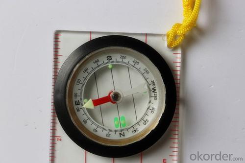
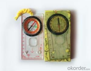
Model: DC45-5W
Name: Professional map compass, ruler compass
Product Origin: China
Supply Ability: 10,000 pcs/month
Minimum Order: 20 pcs
MOQ for OEM package: 500pcs
Product Size: 114*60.5*167(mm)
Features of DC45-5W
1, professional usage: orientation, distance measuring, measuring slope, azimuth and pitching Angle measurement, drawing, a magnifying glass
2, high quality compass with neck rope, portable and rugged
3, ACRYLIC material, about 2mm thick
4, Damping Dial: to keep the stability of the pointer, more suitable for outdoor environment.
5, Accuracy: accurate and clear, there were 360 degrees azimuth Angle, outer ring is 64-00 system, Liquid filled in the compass for reliable readings.
6, Magnifier function
5,ruler compass,
6,for map measure and drawing
7,one meter neck rope,
8,Liquid filled in the compass for reliable readings,
9, magnifier function.
- Q: I would like to ask the GPS handset and GPS receiver (Surveying and mapping qualification application needs) is there a difference? If yes, what is the difference?
- This is the case, GPS handheld refers to a thin hand, while the GPS receiver refers to the RTK host, equivalent to the base station in our industry said. The general application of Surveying and mapping qualifications are required for this application, referred to as RTK (1+1) set, level, theodolite, total station, walkie talkie, technical personnel.... And so on, are essential equipment.
- Q: GPS Mu meter which brand is good, handheld high-precision land area measuring instrument
- A German born mu can also recommend a good precision measuring instrument.
- Q: Can a handheld navigator connect a cell phone? Thank you
- Open the phone hotspot WiFi, handheld navigator connected to this wifi.
- Q: I am a handheld GPS precision is low, how to use to be able to improve certain accuracy.
- Look at the maximum accuracy of GPSIf the difference accuracy can reach 1cm you can connect CORS single base station and other network RTK way to achieve the corresponding accuracy
- Q: Handheld GPS charge is not into electricity what is the reason
- 3, restore the factory settings to see whether the system is.4, the battery damage, can replace the battery repair.
- Q: My cell phone: HTC Hero 200Question type: Internet softwareMy work needs to locate, record, output, and input GPS coordinates. Track record measurement, coordinate transformation. So would you have a professional security software under the table, so go out with a mobile phone or a PAD, or N equipment back to survey the tired,
- Taobao to enter the online shopping, mobile phone navigator on the line, I suggest you download the Careland navigation map, or tiger map
- Q: I am a handheld GPS precision is low, how to use to be able to improve certain accuracy
- Look at the maximum accuracy of GPSIf the difference accuracy can reach 1cm you can connect CORS single base station and other network RTK way to achieve the corresponding accuracy
- Q: How about the accuracy of the GPS handset?
- So the selection depends on your needs the function and budget. Haida official website mall "mobile MGIS mall".
- Q: How to upgrade handheld navigator
- Hello to the brand's official website to download the latest map copy to memory card on the lineI wish you a pleasant car!
- Q: Handheld GPS purchaseHandheld GPS navigator!Is mainly used for tourism, I said is not a mobile phone, is a more professional handheld GPS navigator for travel outside! Handheld GPS navigator can voice navigation?
- If it is only used for general tourism, then hundreds of pieces of GPS is enough, go to the computer city to see, there must be sold, or go to your city to look at the outdoor store
Send your message to us
Good Mapor Ruler Mini-Compass DC45-5W for Surveying
- Ref Price:
-
- Loading Port:
- Tianjin
- Payment Terms:
- TT OR LC
- Min Order Qty:
- 20 pc
- Supply Capability:
- 10000 pc/month
OKorder Service Pledge
OKorder Financial Service
Similar products


Hot products


Hot Searches

