
High-end GIS K8
- Ref Price:
-

- Loading Port:
- China Main Port
- Payment Terms:
- TT OR LC
- Min Order Qty:
- -
- Supply Capability:
- -
OKorder Service Pledge
OKorder Financial Service
You Might Also Like


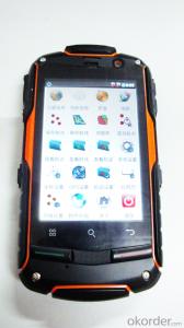
PJK 8 is a GPS data collection devices based with smart tablet Android operating system; 3.5 Cunban through the half- screen which is visible under bright light , high-resolution , ultra-thin , rugged design, easy to complete the wild variety of environments data collection ; built-in 3G data acquisition allows interaction within and outside the industry that has quickly realized .
Product Features
1, the basic functions
Operating system : Android 4.0, massive applications at your fingertips
Processor : 1GHZ processor speed
Memory capacity RAM: 512MB ROM: 4G
Memory card : MicroSD (TF) card , up to 32GB
2 , data collection
Data acquisition system with professional mobile GIS data collection , field mapping, waypoint storage coordinates to calculate the length , angle , and other areas of field measurement data , with a key two-coordinate conversion function .
3, GPS features
Differential : Support SBAS (MSAS, WAAS, EGNOS)
Real-time differential :1-3m
Single precision :3-5m
4 , communication performance
Built-in GSM and WCDMA communications , high-speed data transfer easy , can support voice calls
Bluetooth : 2.1 + EDR
WIFI: Support 802.11 Wireless LAN
USB: 2.0
5, the extended application
5 million pixel camera , 300,000 auto-focus camera ,
Video capture,
Built-in microphone supports voice attribute collection
Built-in electronic compass ,
Under no circumstances can indicate GPS direction , support multiple GPS intelligent navigation software
Support for emergency lighting and portrait and landscape screen automatically switches .
1, the physical properties of
Size : 125 * 65.5 * 20.5MM
Weight : 204G
Working temperature: -20 to 65 degrees
Storage temperature : -40 ℃ ~ 70 ℃
Humidity : 100 % non-condensing
Waterproof and dustproof : IP67
Anti- fall drop : Anti 1.5 meters free fall
Roll : Roll 1000 0.5 m height
Rugged and lightweight : GE Industrial grade high fire-retardant materials plus lightweight structure designed to allow field operations no longer be a burden.
2 , the display characteristics
Display: 3.5 -inch
Type: Multi -point capacitive touch screen
Brightness: anti-glare display, highlight
Resolution : 320 × 480
3, the power characteristics
Battery : 2000mAH Lithium Battery
Working hours : 10 hours of continuous work
4 ,Quality Certification
Product complies with EU CE, ROSH standards, China 's national quasi- GB 21288-2007 requirements
- Q: I would like to ask the GPS handset and GPS receiver (Surveying and mapping qualification application needs) is there a difference? If yes, what is the difference?
- This is the case, GPS handheld refers to a thin hand, while the GPS receiver refers to the RTK host, equivalent to the base station in our industry said. The general application of Surveying and mapping qualifications are required for this application, referred to as RTK (1+1) set, level, theodolite, total station, walkie talkie, technical personnel.... And so on, are essential equipment.
- Q: GPS Mu meter which brand is good, handheld high-precision land area measuring instrument
- A German born mu can also recommend a good precision measuring instrument.Simple operation, the screen is large, a few buttonsBoot, and then look at the star almost, to find a field, start and then click on the end of a circle, out of the number ofElectricity can alsoPrecision mody... With a special RTK or not, but what is sure to measure a circleFlat measurement of quasi accurate, biased on what is almost, it can be accepted
- Q: Is it accurate to measure highway mileage with GPS handheld
- As long as you can receive more than four satellites, and the signal is good, the accuracy should be high.
- Q: Handheld GPS navigation is what? Where to buy handheld GPS navigation, how to select GPS navigation?
- Select the main consideration of the following issues on the line:1, GPS receiving capacity, in the interior, the streets can be measured on a few stars, while looking at the speed of the search star? If a place for 2 - 3 minutes accurate positioning can be used2, the map is the latest, often used to check those routes3, battery life is how long to ask4, accessories, such as support, car charge, the size of the memory card should be clearly presentedThe location of the purchase is usually in the car decoration department or the electronic mall or digital products store salesAffordable mall can look at the old brand, operating for many years, where I bought the electronic dog
- Q: What is the difference between industrial GPS handset and mobile navigation
- I am a professional to do GPS, the difference between the professional handheld and mobile GPS is very understanding, here and your simple communication.1, GPS is the most important positioning accuracy and confidence. Professional handheld GPS chip used to stabilize the performance of some, the accuracy will be better, such as Garmin handheld high-end product positioning can be achieved within 3 meters, while the phone's GPS chip is different.2, both in the design and positioning of the crowd is very different. Professional GPS more focus on outdoor industry and users, the use of design idea is how to better outdoors, outdoor tourism including tourism exploration assistant very full function, and mobile phone GPS is a trend not only, what purpose.
- Q: What do you need to test for GPS?
- 3 positioning time this means when you restart your GPS receiver, it determines the time required for the current position. For the 12 channel receiver, if you are in the last position near the location of the cold start time is 30 seconds to 5 minutes, hot start is usually 5 to 40 seconds, and for the 2 channel receiver, most of the cold start more than 15 minutes, hot start 2 to 5 minutes. The positioning accuracy of the positioning accuracy of 4 which is obtained in the case of no WAAS/EGNOS conclusion, rather than most of the GPS receiver specification of the positioning accuracy, can look at the test report of others so before the purchase of GPS, now on the market with 12 channel GPS receiver error level is generally not more than 30 meters, height error not more than 50 meters, the average error is about 15 meters. Due to the use of the module, our product positioning error is about 10 meters,
- Q: I am a handheld GPS precision is low, how to use to be able to improve certain accuracy
- If you can join the CORS network, the accuracy of decimeter to centimeter level.
- Q: Saying that we have a project in front of it is to do so, it is surprising that there are wood
- It is really unexpected, basically not, the accuracy is not enough!
- Q: I just bought a handheld GPS Magellan No. 1, showing the latitude and longitude coordinates, I want to set the geodetic coordinates of latitude and longitude, do not know where to set, I would like to ask you, how to set, there is a better picture shows the best, thank you so much.Magellan GPS 210 is not 2000 shy
- Latitude and longitude is the geodetic coordinates, the landlord said to be set up for the use of the projection plane Cartesian coordinates - Beijing 54 or Xi'an, the 80 plane rectangular coordinates it.1 position: [format setting unit - "[] position display format is set to User UTM Grid, and enter the relevant parameters, such as the 3 degree or 6 degree with the area with the central meridian projection, the ratio was 1, that deviation is 500000m, north-south deviation is 0.
- Q: Handheld GPS, the measurement of arable land, fixed point and circle test, which is more accurate,
- If the area is measured, are almost. However, if the measurement point is only the case, the dynamic GPS is now the general error can be guaranteed within 3cm, the total station can be guaranteed to the millimeter.
Send your message to us
High-end GIS K8
- Ref Price:
-
- Loading Port:
- China Main Port
- Payment Terms:
- TT OR LC
- Min Order Qty:
- -
- Supply Capability:
- -
OKorder Service Pledge
OKorder Financial Service
Similar products

Hot products


Hot Searches
Related keywords

