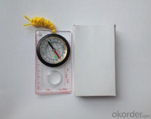


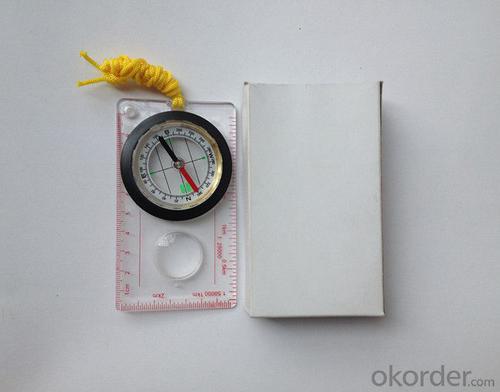

Good Mapor Ruler Mini-Compass for Surveying
- Ref Price:
-

- Loading Port:
- Tianjin
- Payment Terms:
- TT OR LC
- Min Order Qty:
- 20 pc
- Supply Capability:
- 10000 pc/month
OKorder Service Pledge
OKorder Financial Service
You Might Also Like


Model: DC45-5A
Name: Professional map compass, ruler compass
Product Origin: China
Supply Ability: 10,000 pcs/month
Minimum Order: 20 pcs
MOQ for OEM package: 500pcs
Product Size: 108*61*16 (mm)
Features of DC45-5A
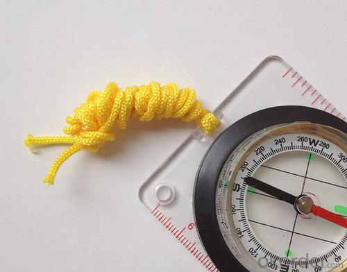
1, professional usage: orientation, distance measuring, measuring slope, azimuth and pitching Angle measurement, drawing, a magnifying glass
2, high quality compass with neck rope, portable and rugged
3, ACRYLIC material, about 2mm thick
4, Damping Dial: to keep the stability of the pointer, more suitable for outdoor environment.
5, Accuracy: accurate and clear, there were 360 degrees azimuth Angle, outer ring is 64-00 system, Liquid filled in the compass for reliable readings.
6, Magnifier function
5,ruler compass,
6,for map measure and drawing
7,one meter neck rope,
8,Liquid filled in the compass for reliable readings,
9, magnifier function.
- Q: I would like to ask the GPS handset and GPS receiver (Surveying and mapping qualification application needs) is there a difference? If yes, what is the difference?
- GPS handheld GPS operating manual, GPS receiver is to receive satellite signals, GPS consists of two components.
- Q: Can you buy a good handheld GPS in China? FiveTrouble master recommended several professional handheld GPS brand, in addition to handheld GPS can speed it? Thank you!!
- The main function is to use navigation as long as the navigation function can be used
- Q: What is GPS Mu meter ah, with the general said that the GPS measuring instrument what is the difference?
- The amount of words on the handheld GPS, Magellan can be both economic and affordable.
- Q: Handheld GPS charge is not into electricity what is the reason
- Two, solutions:1, for other chargers, or data lines try, or clean the charging port.2, boot into recover mode advancsd advanced mode, select the wipe Battery, remove battery traces.
- Q: Handheld GPS and mobile phone GPS what is the difference?
- The same: GPS main chip may be the same; can complete the GPS positioning;
- Q: What do you need to test for GPS?
- 5.DGPS you know, differential GPS (DGPS) positioning accuracy is very high, some GPS equipment providers set up a DGPS transmitter in some areas, free of charge to its customers, if customers are buying GPS receivers with DGPS function. The DGPS transmitter is a fixed GPS receiver (in a 100km ~ 200km exploration scene in the radius setting) receive satellite signals, it knows exactly what is the exact time of transmitting satellite signal to the theory, and then compare it with the actual delivery time, then calculate the "difference", influence this is very close to the atmospheric refraction, it will send out the difference, usually with FM (FM) radio data transmission using subcarrier modulation signal in the baseband receiver, GPS and DGPS function can receive and use it more accurate positioning.
- Q: Saying that we have a project in front of it is to do so, it is surprising that there are wood
- It is really unexpected, basically not, the accuracy is not enough!
- Q: How about the accuracy of the GPS handset?
- Zhonghaida Q1:2 zhonghaida Q5:1 meters; meters; zhonghaida Q6: decimeter; zhonghaida Q8 cm;
- Q: Magellan GPS handheld why so many people choose not to say that the map is not good
- Magellan GPS handheld maps are not even, it is said that the map even money! No need ah.
- Q: Ask how to select a google satellite map into a handheld Area GPS
- If an ordinary mobile phone GPS, can install Orville interactive map support pre download any regional satellite map, support for offline use.
Send your message to us
Good Mapor Ruler Mini-Compass for Surveying
- Ref Price:
-
- Loading Port:
- Tianjin
- Payment Terms:
- TT OR LC
- Min Order Qty:
- 20 pc
- Supply Capability:
- 10000 pc/month
OKorder Service Pledge
OKorder Financial Service
Similar products


Hot products


Hot Searches

