
Rugged handheld GIS K7
- Ref Price:
-

- Loading Port:
- China Main Port
- Payment Terms:
- TT OR LC
- Min Order Qty:
- -
- Supply Capability:
- -
OKorder Service Pledge
OKorder Financial Service
You Might Also Like


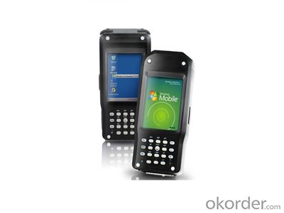
PJK 7
Detailed Description
1.Lemon coaxial external antenna connector
2.High sensitivity integrated antenna
3.USB: Mini B/slave
PJK 7
PJK 7 is a bran-new rugged handheld GPS/GIS equipment. It provides a complete set of all necessary features required of a mapping device for anyone who needs productive data collection and efficient asset management in the field. Through post-processing, the positions of every GIS feature you collect can be better than sub-meter-level accuracy.
The innovative design integrates all the communication components offering an all-in-one robust solution to the user. The PJK 7 offers a unique design with various crackajack capabilities. It includes internal and removable battery, internal memory, specific kits per application and full compatibility with various software solutions from the third part.
The PJK 7 comes with Microsoft Windows Mobile 6, a color touch-screen, and has Bluetooth for wireless connectivity. This handy feature-rich GPS includes an integrated 3-megapixel camera, an embedded speaker and microphone to enrich the collected data with pictures and voice notes.
High performance fully rugged handheld for real-time communication in any harsh conditions:
l MIL-STD 810G and IP65 Compliance
l 128M RAM/128M ROM
l Microsoft Windows CE 6.0
l 400MHz Mobile Computing Platform
l Portrait 3.5″QVGA(240×320),
Transflective sunlight readable display
Pressure sensitive touchscreen
l SDIO / SDHC Card Slot for Flexible
Expansion and Storage
l Field Swappable 1900mAh Li-Ion,
Battery with Long Battery Life
(12Hours without GPRS)
l Embedded High Sensitivity GPS
l Embedded Bluetooth 2.0 module
l Embedded 802.11b/g WLAN module
l Receiver and 3M Pixels Auto-focus Camera
l 2.5G/3.5G WWAN (HSDPA / WCDMA /EDGE / GPRS / GSM)(Option)
l Embedded RFID module (Option)
l Lemon coaxial external antenna connector
Package Contents
The PTK 7 handheld device package contains:
− 1 PJK 7 handheld device
− 1 USB data communication cable
− 1 Rechargeable battery pack
− 2 Styluses
− 1 Power adaptor
− 1 CD-ROM Software Development Kit and User’s manual
− 1 Warranty card
Optional Accessories
- External GPS survey antenna
- Hand Strap
- Carrying case
- Charging on cradle
System
- Microsoft Windows CE 6.0 Professional
- Processor:400 MHz
- 128MB DRAM and 128MB Flash ROM
- Display 64K Color TFT LCD with 320 x 240 pixel resolution, with LED backlight and touch screen, Advanced sunlight readable display.
GPS Characteristics
20 parallel channels
Integrated SBAS(WAAS,EGNOS,MSAS)
L1 C/A code and carrier
Update rate: 1Hz
Protocol: NMEA 0183 v 3.0
RTCM SC-104 version 2.3(9.2 &1.2)
High sensitivity integrated antenna
Accuracy Specifications
Real-Time Performance (RMS)
- 80cm with VRS/CORS corrections
- 1m with one base corrections
Post-processing Performance (RMS)
- 40 cm
Static Survey Performance (RMS)
(With need external survey antenna)
- Horizontal:0.005m + 1ppm
- Vertical:0.01m +2ppm
Mechanical Features
- Dimensions (L x W x H): 17.5 x 8.2 x 4.1 cm
- Weight: 450 g (incl. battery)
Power Characteristics
- Battery type: 7.4V lithium-ion,1900mAh
- Removable, Rechargeable battery
- Battery life:
Over 12 hours run-time with GPS
Over 6 hours run-time with GPS and wireless communication
- External power port for extended operation time
Environmental Features
- Operating temperature: -20° to + 50 °C
- Storage temperature: -30° to +70 °C
- Humidity: 90% non condensing for temperatures < 40°C
- Protection: IP65
- ESD protection: 8 KV contact discharge, 15 KV air discharge
- Drop resistance: 1.2 m / 4 ft
Interface
- Integrated Bluetooth/802.11b/g WLAN wireless technology
- Lemon coaxial external antenna connector
- USB: Mini B/slave
- Integrated 2.5G/3.5G data-link (option)
- 3-megapixel digital camera
- Port for communication Dock
Option
- 2.5G/3.5G Wireless module
- RFID Module
Stand Software
- GISMAPPING Software
Receiver Description
Front Panel
- Q: GPS Mu meter which brand is good, handheld high-precision land area measuring instrument
- A German born mu can also recommend a good precision measuring instrument.
- Q: Handheld GPS locator measuring accuracy is about how many meters?
- The handheld machine precision is generally divided into: centimeter decimeter level, 1 meters, 2 meters, 3 meters, 5 meters;
- Q: Seeking the similarities and differences between RTK and GPS
- GPS is a satellite system of the United States, is a kind of GNSS, GPS is widely used in surveying and mapping, the use of static and dynamic, RTD, dynamic RTK, RTK is a real-time dynamic difference, the accuracy of centimeter level, that is to say RTK is a GPS application method
- Q: Handheld GPS brand rankings
- SIBAOIn the GNSS coordinate precision and attributes, "SIBAO" has a professional GPS handset, GIS i-PPP GIS, a mobile data collector, GIS, high precision GIS, high precision measurement of RTK complete product structure, to form a comprehensive solution to the spatial information industry scheme. Set of SIBAO products awarded the Beijing independent innovation product identification certificate, satellite navigation and Engineering Excellence Award and other professional awards. At the time, location, navigation and other comprehensive applications, Unistrong successful implementation of hundreds of large projects, services in many national key projects, won the national honor.MagellanGarmin
- Q: Handheld GPS which brand is good
- Now GPS can also do handheld measurement accuracy, precision can usually reach decimeter level, the industry there are relatively well-known Huace, professional GPS measurement instrument, high precision of handheld GPS the good.
- Q: Verify the accuracy of the GPS device to buy back, the way is to use Android under the'gps state 'software, to test the accuracy of real-time single point positioning.1 with two sets of the same Android Tablet Computer (custom machine, type of bad) in the same position for receiving, find that the accuracy is the same (software, are 1-2 meters), but the position would be poor 10 meters or more. It's in the same place.The 2 one is the Android tablet computer, a mobile phone is HTC G10, also received together in the same position, find that the accuracy is not the same as (the latter 20 meters or so), but also may be about 10 meters position difference.The accuracy of this GPS device can reach 1-2 meters, while the same location in real-time single point positioning error of 10 meters, a reasonable explanation.
- Oh, together with the exchange of learning, mutual verification, I said that is my experience. Software tells you that the accuracy is handled and limited, especially for some third party software. If you do not limit the scope of the conditions, the limit is too difficult to determine. If the satellite in poor condition, serious occlusion, satellite time difference, let alone ten meters, a few dozen a hundred meters are possible. Under normal circumstances, single point positioning accuracy is about ten meters, of course, sometimes all aspects of the conditions are very good, a few meters are also some. As for the accuracy of the GPS that you say htc10 and tablet computer, to this kind of navigation type GPS, from the respect of the respect that the instrument says, the accuracy should be in 10 meters to 15 meters (all the conditions are all right). Oh exchange!
- Q: What is the difference between a hand-held GPS and a car's onboard navigator
- As the first floor of a friend to answer the same, the general application of hand-held devices in land surveying, mountain climbing and other precise positioning when measuring the use of. Long standby time, three good performance. Easy to carry. A single charge can be used for a long time (depending on the machine). Although navigation, but the map is not detailed. At the same time, there is an opportunity to have latitude, latitude and other information.The car navigation is designed for users to drive out, in the field when not familiar with the road, ah, not familiar with the surrounding buildings, such as parking, hospitals, restaurants, gas stations. Used. Map details. But does not provide information such as latitude accuracy. No elevation.Look what you're doing. There is also a mobile phone navigation function.If you are purely for entertainment, then choose the phone.If you want to navigate in the car, select the vehicle navigation.If you are a very professional outdoor sports enthusiasts on the choice of handheld.
- Q: Welcome to make comments on the existing GPS tour pal what shortcomings to answer the more detailed the better
- Fifth elements: the terrain map is the main project of outdoor sports climbing, mountain climbing is very exhausting, we usually do a plan will be completed on schedule, a good plan should be to our destination in the manual run out before. And if you want to do this, it must be on the road difficult to have a correct anticipation. But this time, with the terrain map GPS can come in handy, the mountains and the altitude of the understanding, we need to know about these sections spend much time and energy. And the general GPS map, is unable to meet the needs. So we'd better buy a map with contour terrain data of professional grade GPS, make your own outdoor journey do in our hands.
- Q: Handheld GPS each brand has what difference; different price difference in where is the positioning accuracy is different or what function is not the same?What are the differences between the measurements and the cars?
- Where the speed of the car, how many miles are open at a glance at the professional GPS locator
- Q: What is the difference between professional navigation and professional GPS navigator
- 5 price of less than 3000 yuan.> 4, 5 a answer: there are PDAGPS mobile phone development, but should be more than 6000. One of the PDAGPS generally above 3000, generally have more than 3000 car navigation. If you have Bluetooth support PDA or PDA phone, plus a Bluetooth GPS is as long as 1000 or so. So the first three choices and then you have only the following three choices: first, the new machine but the older models, businesses dumped, and the other is to know the people, and the three is a vintage.More well-known brands in the market: Taiwan (MIO), the new branch, Taiwan HOLUX long days, GARMIN, HP, etc.PDAGPS mobile phone: MIO A700, E, TATO588, HP6515PDAGPS development: MIO168, 169, 269, P350, HOLUX PolarisVehicle navigation: MIO C210, new section four or five, GARMIN three or four
Send your message to us
Rugged handheld GIS K7
- Ref Price:
-
- Loading Port:
- China Main Port
- Payment Terms:
- TT OR LC
- Min Order Qty:
- -
- Supply Capability:
- -
OKorder Service Pledge
OKorder Financial Service
Similar products
Hot products


Hot Searches
Related keywords

