
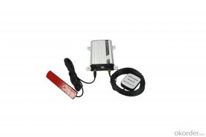
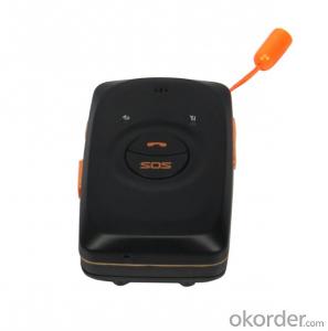
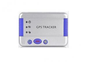
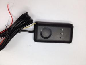
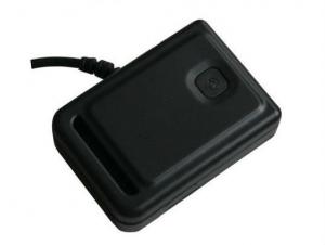
Waterproof Mobile Phone GPS Trackar with High Quality
- Ref Price:
-

- Loading Port:
- China main port
- Payment Terms:
- TT or LC
- Min Order Qty:
- 1000 set
- Supply Capability:
- 100000 set/month
OKorder Service Pledge
OKorder Financial Service
You Might Also Like


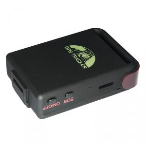
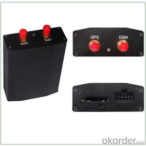
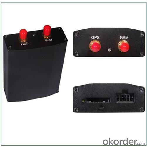
Waterproof Mobile Phone GPS Trackar
Product Features
1. Check the location on the map by smart phone with the Google map's URL.
2. Track by mobile SMS to get the GPS coordinates.
3. Track on gps tracking platform.
4. With LCD display to show the time & GPS coordinates information.
5. Two-way talking function, with 2 shortcut buttons for fast calling out 3phone numbers.
6. Geo-fence alert.
7. SOS button to call for help in case of emergency.
8.Low battery alert.
9. Monitor the voice remotely.
10.Store GPS information when there is't GSM signal
11. Watch-like design, portalbe, small size.

Product Parameter
GSM Frequency | 850/900/1800/1900MHZ |
| Gps chip | G-TOP |
| GPRS | class12,TCP/IP build in GSM MODULE |
| GPS Sensitivity | -159dbm |
| GPS Accuracy | 10m(2D RM) |
| GSM Accuracy | 10-50m |
| Speed Accuracy | 0.1m/s |
Cold Status | -38s |
| Warm Status | -32s |
| Hot starus | -2s |
| MaximumAltitude | 18000m |
| Highest Speed | 515m/s |
| Acceleration 0f Gravity | <4g |
| Size | 120*54*23.5(mm) |
| Weight | 0.7kg |
| Working Tememperature | -20--+ 70°C |
| Humidity | 20% --80%RH |
| Battery | 500MAH |
| Standby time | 20h/5min GPRS Mode 48h/SMS Mode |
| Screen Size | 1.51inch |
FAQ:
- Q: What can we do for the special customer?
A: Provide custom made service with customer's drawing; We make sure to provide you with the best solutions for your individual case. Whether standard items or non-standard items.
- Q: What can we supply?
A: We provide high levels of communication from start to finish.
- Q: What is our advantage?
A: Top Cemented Carbide has extensive business experience, Fast delivery and high quality.
- Q: Not exactly what kind of express orders, the goods is how to achieve GPS positioning. Or the cargo is equipped with satellite locator, or what kind of.
- Regular express have GPS positioning, and the road car handle is a one-time thing to seal up
- Q: Phone can not locate GPS
- 1 make sure GPS is in a state of play2 on the use of software to restart the phone to play GPS lookThe 3 have basically concluded mobile phone GPS module is broken or repair it directly for cheap.
- Q: Chengdu GPS locator installed there
- 3, cross-border alarm: under the state of defense, the vehicle moves beyond the set range, will trigger the alarm. Alarm information automatically sent to the monitoring center and the owner of the phone.4, online search car: positioning, monitoring, historical trajectory query, marking locations and other operations, providing the latest electronic maps, GOOGLE maps, three-dimensional satellite map.5, web alarm: overspeed alarm, regional alarm, web pop-up alarm tips.6, data statistics: speeding statistics, mileage statistics, speed statistics, alarm statistics.7, cut off the oil: you can cut off the oil off the computer remote, so as to play the role of anti-theft
- Q: At present, the accuracy of civil GPS in the end is how much?
- The navigation accuracy of GPS type belongs to the single point positioning accuracy, probably between 3~15 meters; high precision measurement of GPS generally refers to the accuracy of RTK, to 10 cm; the accuracy of WGS84 coordinates accuracy; usually see vehicle navigation or mobile phone navigation precision is high when there is a map of the correct.
- Q: Use method of real carpenter locator
- 2 the use of this is a more common way of using.1) the use of road point: commonly used to determine the coordinates, to determine the rock caves as starting point, line or other coordinates, the coordinates of the point of turning. Easy to use, MARK a coordinate on the line.Find a point: to find the location must have to sign (landmark/waypoint) exists in the form of GPS in the memory, you can MARK or from previously visited a friend to get data, manual / computer into sign data upload. Press the GOTO key to select your destination from the list, and then go to the "guide" page, which will show you away from the target distance, speed, direction of the target angle and other data, according to the direction angle can be.2) the use of input line: if you can find the route route information had been recorded by friends, they enter the GPS forming line, or (in return) to the previously recorded signs edited into a line.Route guidance: put a route according to the activation, and looking for "the same way," guidance "page will lead you to the first point, the route once arrived, the target will automatically replace the next road," second point oriented "page to lead you to the line. If you deviate from the route over some intermediate point, once you go back to the line," targeting "you will skip around those points, for your current position corresponding to the next point on the line.
- Q: How to set up the GPS locator fence alarm
- The use of Kankes GPS locator electronic fence set method: use your account number and password landing route strong car online platform landing in the middle of the map there is an icon to click "more""
- Q: GPS satellite positioning card how to apply for network services?
- First look at the platform with the positioning of the product hardware and software network are home in accordance with the product brand to find the corresponding service management and monitoring platformIt is necessary to shift the flow of cards to the service platform to pass the data flow of mobile phone cards to choose less than 30M traffic packages per monthGood luck
- Q: How to locate the car car
- First, buy a satellite on the Internet to install the car, you can use a mobile phone or computer to locate the car,
- Q: Car GPS locator is not a battery
- Hello, there is a battery connected to the original car power
- Q: What are the benefits of using the vehicle GPS locator
- Real time to know the location of the vehicle, check the history track
Send your message to us
Waterproof Mobile Phone GPS Trackar with High Quality
- Ref Price:
-
- Loading Port:
- China main port
- Payment Terms:
- TT or LC
- Min Order Qty:
- 1000 set
- Supply Capability:
- 100000 set/month
OKorder Service Pledge
OKorder Financial Service
Similar products
Hot products


Hot Searches
Related keywords

