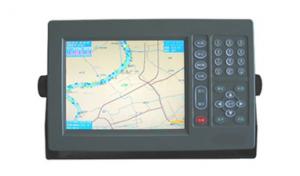
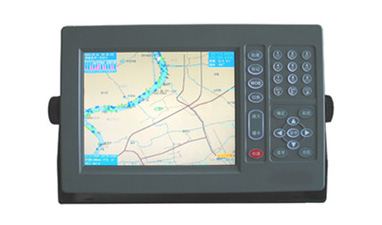
Marine GPS Navigator 1008
- Ref Price:
-

- Loading Port:
- China Main Port
- Payment Terms:
- TT or LC
- Min Order Qty:
- 1 Set/Sets set
- Supply Capability:
- 1000 Set/Sets Per Year set/month
OKorder Service Pledge
OKorder Financial Service
You Might Also Like
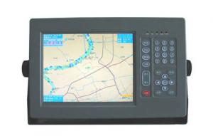


Physical & Performance of GPS Navigator | |
Unit dimensions, WxHxD | 5.9" x 6.1" x 2.4" (15.0 x 15.5 x 6.1 cm) |
Display size, WxH | 3.0" x 4.0", 5.0" diagonal (7.6 x 10.2 cm, 12.7 cm diagonal) |
Display resolution, WxH | 480 x 640 pixels |
Display type | VGA display |
Weight | 1.7 lb (0.8 kg) |
Battery | none |
Battery life | none |
Waterproof | Yes (IPX7) |
High-sensitivity receiver | Yes |
Antenna | internal |
NMEA input/output | NMEA 0183 compatible and NMEA 2000® certified |
Power consumption | 0.6A at 12V; 0.3A at 24V
0.8A at 12V; 0.4A at 24V (with sonar) |
Maps & Memory of GPS Navigator | |
Basemap | Yes |
Preloaded maps | No |
Ability to add maps | Yes |
Built-in memory | none (cannot load maps to internal memory) |
Accepts data cards | dual microSD™ card slots |
Waypoints/favorites/locations | 5,000 |
Routes | 100 |
Track log | 50,000 points; 50 saved tracks |
Features & Benefits of GPS Navigator | |
Touchscreen | No |
Supports AIS (tracks target ships' position) | No |
Supports DSC (displays position data from DSC capable VHF radio) | No |
Audible alarms | Yes |
Tide tables | Yes |
Hunt/fish calendar | No |
Sun and moon information | Yes |
Automatic routing (turn by turn routing on roads) | No |
Headphone jack/audio line-out | No |
Audio/video input/output | No |
Portable | No |
Automotive/motorcycle-friendly | No |
- Q: Small fishing boat. A remote fishing village. Reef。 Map。,,,,,,,,,,,,,,,,,,,,,,Know the trouble to help ah... Thank you.
- Dude, you say something, or you want to function, domestic Beidou system has, the foreign GPS also, but remember, must take the function of electronic chart, I met many fishermen and fishing boats in the sea, all with the use of electronic chart function of radar or GPS, it is said that the domestic commercial Beidou system and also, terminal equipment can be used, you need to consult the specific dealer!
- Q: High frequency. SSB radio. Satellite navigationI want to study marine electronic equipment, a variety of marine radar. High frequency. Single sideband radio. Satellite navigation. All the fish finder. Sounder maintenance and so on which can enlighten me, where is the training school, I graduated for several years, I want to learn the craft.
- A marine radar is enough for your study, you can consult the Xiamen Marine College Jimei University, where many teachers navigation equipment maintenance, if you are born in the navigation technology specialty, the better, directly in your school can learn.
- Q: I would like to study the maintenance of marine radar navigation technology, I do not know where to go
- Is it a student or a job?Students are advised to go to the school of information, Dalian Maritime University, or the Institute of navigation have relevant professionalWork is more, Shanghai, Shenzhen, Guangzhou have.
- Q: Navigation GPS can store the number of turning points ah
- My classmates went to play the test had set 27Route point on the estimated 300 is no problem,
- Q: Who can give a world map of the great navigation era OL
- Give you an e-mail address to send a GPS software, he has spent half a year. security
- Q: Three necessary conditions of ancient ocean navigation is: ______ navigation, use the rudder steering, the effective use of ______.
- The three necessary conditions of the ancient ocean navigation are: using the compass navigation, using the tail rudder to grasp the direction, and effectively using the wind forceThe answer is: compass, wind
- Q: What navigation instrument was used by Zheng He in the voyages of the West
- Ian, large Ian,Use the chart to locate and Ian navigation
- Q: (listed as the following 4 points) due to the literature in this area is not easy to find.. So God help you a lot of trouble ~ if you have the relevant Chinese and English (the best English), then sent to The more, the better..1 development process: divided into several stages, major events of the year, turning point, the extent of the current application, advantages and disadvantages2 technical issues: key technologies, difficulties and limitations3 outlook4 GPS in the field of enlightenment to us
- 1.7 other applicationsThe navigation technologies used in this paper are as follows: GPS (GNSS); sonar technology; INS; navigation chart; radio navigation technology; image matching technology; other technologies.The communication technology mainly includes: FM and TV subcarrier unidirectional data / voice communication; beacon network bidirectional data communication; trunking communication; cellular communication; digital land mobile communication; satellite mobile communication; traffic trail communication etc..The first 5 kinds of communication technologies are mainly used in coastal, inland river and lake area.
- Q: GPS can you measure the course? Which is more accurate than the compass course?GPS can also measure the flow rate and flow? The log is how to measure the velocity and direction? Which precise? Whichever shall prevail?GPS how to measure the air pressure difference?GPS how to measure the magnetic difference? How to measure the day no time? How do you get it? Accurate?
- GPS measurement of a lot of Tianbao SPS series, support for dual antenna, a positioning, a directional. The flow rate and the flow direction are strictly impossible to measure, but can be loaded into other devices. I don't know what you mean, I don't know. It should mean the magnetic declination, cannot be obtained by GPS specific value can be calculated by the relative position of multiple, eliminate the influence of magnetic declination.
- Q: Can the GPS satellite monitoring system be used in navigation?
- Of course, the navigation ability of the GPS system is no matter where, as long as it covers the range, and have accepted the device can be used on the ground for vehicles and other navigation sections, also in the sea for the ship navigation
1. Manufacturer Overview
| Location | Jiangsu,China |
| Year Established | 2008 |
| Annual Output Value | US$1 Million - US$2.5 Million |
| Main Markets | Mid East;Eastern Europe;South America |
| Company Certifications |
2. Manufacturer Certificates
| a) Certification Name | |
| Range | |
| Reference | |
| Validity Period |
3. Manufacturer Capability
| a) Trade Capacity | |
| Nearest Port | Shanghai |
| Export Percentage | 81% - 90% |
| No.of Employees in Trade Department | 150 |
| Language Spoken: | English, Chinese |
| b) Factory Information | |
| Factory Size: | Above 20,000 square meters |
| No. of Production Lines | 20 |
| Contract Manufacturing | OEM Service Offered;Design Service Offered |
| Product Price Range | Average |
Send your message to us
Marine GPS Navigator 1008
- Ref Price:
-
- Loading Port:
- China Main Port
- Payment Terms:
- TT or LC
- Min Order Qty:
- 1 Set/Sets set
- Supply Capability:
- 1000 Set/Sets Per Year set/month
OKorder Service Pledge
OKorder Financial Service
Similar products
Hot Searches
Related keywords

