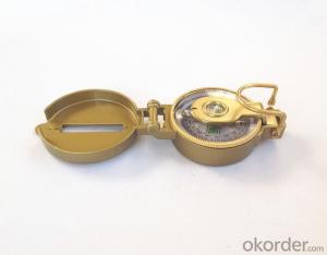
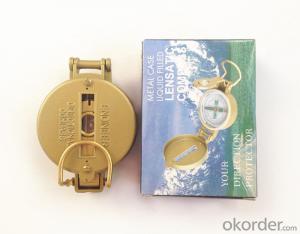


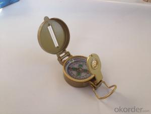
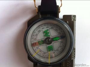
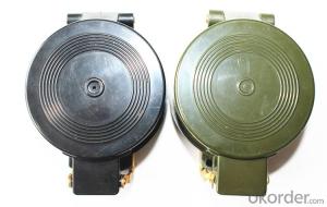
Metal Military or Army Compass DC45-3A
- Ref Price:
-

- Loading Port:
- China Main Port
- Payment Terms:
- TT OR LC
- Min Order Qty:
- -
- Supply Capability:
- -
OKorder Service Pledge
OKorder Financial Service
You Might Also Like


Product details of the compass :
Model: DC45-3A
Name: Military compass, Army compass, Metal compass
Product Origin: China
Supply Ability: 10,000 pcs/month
Minimum Order: 50 pcs
MOQ for OEM package: 500pcs
Product Size: 76*53*26 (mm)
Color: Black
Shipping of the Compass:
(1)By sea (FOB Tianjin, CIF or other trade terms)
Low shipping cost & slow delivery (7-30days shipping days a different countries , Suitable for container and bulk, at the same time, non-urgent delivery)
(2)By courier express: DHL, FedEx or TNT
Swift delivery (2-5 work days ),but it will cost much .and door to door for the parcel.
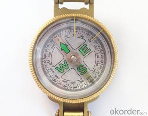
Compass Features:
1)Can easily folds to fit in your pocket
2) The compass is highly accurate and features a liquid-damped compass card with a luminous dial that can
easily be read at night, and a standard bezel with two yellow lines at 45 degree angles
3) The bezel rotates with detents every 3 degrees so you can change the heading reference a known amount without looking at the compass
4) The front sight has a magnifier to simultaneously view the magnetic heading when taking a sight
5) A second magnifier assists in reading the magnetic heading when direct viewing from above
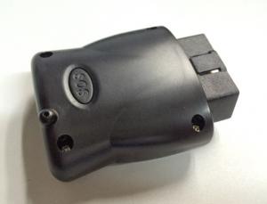
- Q: What is a GPS positioning system?
- Is where you squat, others can know that kind of equipment.
- Q: How to locate the location of a private car with a mobile phone?
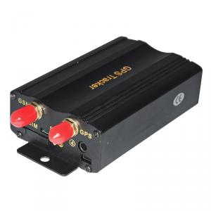
- The third step: wiringAfter installing the card, go back to the first step. Installation of a variety of color line order to ensure that the connector is not loose, not water. Please use the connection process auto circuit wiring method standard, do not do things carelessly. Wiring processing is not good, on the one hand, it is easy to make the GPS locator power fail to work, there are some short circuit fire safety risks.
- Q: I drive a friend's car, I want to know if his car is a satellite positioning system, in the absence of his case, how can I know?
- A little; look at the back of his car is not equipped with a small probe, there is probably a big GPS.Second: look at his car there is no display, usually 9 inches screen.Third; there is no antenna.
- Q: GPS locator tracker is always in the offline state is how to send text messages are appropriate. Send text messages back. WeChat or this.Baidu is the time to look at the map display offline
- Two, the phone can get through but platform show offline (with rice GPS locator for example)?A: 1, first try to query the state, STATUS# query GPRS state if disconnected link down, enter the, if the GPRS state is connected to the platform link up, enter the view.2, the instruction PARAM# to see whether the corresponding IMEI number, if the display 38160000000000168 IMEI number has been lost need to return to the factory.
- Q: Car GPS locator installed in the car where the location is good
- Door partition;Under the trim panel under the windshield;Front bumper, need to pay attention to waterproof;Under the windshield wiper, need to pay attention to waterproof
- Q: Which satellite positioning system is used on Baidu maps?
- Baidu maps do not have their own satellite positioning system. GPS satellite positioning system.
- Q: Bad weather will affect the GPS locator accept signal
- Hello, such as clouds thick fog and haze will affect the situation
- Q: Samsung mobile g7106 navigation GPS positioning slow what reason
- Samsung companies know, to provide you with quality solutions, intentions to answer your questions, hoping to get your satisfaction evaluation.
- Q: How to install and use car GPS locator
- 3). Wiring little trouble spots, to take the line, according to the different functions to set an gt02a car like rice only positioning function, only the positive and negative two lines, pick up convenient; like the gt06n function, then the line is very much, like the ACC line, relay line etc..
- Q: Method of use of GPS
- 2 no map use. 1) the use of road point: commonly used to determine the coordinates, to determine the rock caves as starting point, line or other coordinates, the coordinates of the point of turning. Easy to use, MARK a coordinate on the line. Find a point: to find the location must have to sign (landmark/waypoint) exists in the form of GPS in the memory, you can MARK or from previously visited a friend to get data, manual / computer into sign data upload. Press the GOTO key to select your destination from the list, and then go to the "guide" page, which will show you away from the target distance, speed, direction of the target angle and other data, according to the direction angle can be. 2) use the route input route: if you can find the route information recorded by the previous friends, type them into the GPS to form a line, or (usually return to the original road) to edit the previously recorded road sign into a line. Route guidance: put a route according to the activation, and looking for "the same way," guidance "page will lead you to the first point, the route once arrived, the target will automatically replace the next road," guidance "page to lead you to the line of second points if you deviate from... The route over some intermediate point, once you go back to the line," targeting "you will skip around those points, for your current position corresponding to the next point on the line. 3) backtracking is actually a special method of input line (route), it is very easy to return to the original path.
Send your message to us
Metal Military or Army Compass DC45-3A
- Ref Price:
-
- Loading Port:
- China Main Port
- Payment Terms:
- TT OR LC
- Min Order Qty:
- -
- Supply Capability:
- -
OKorder Service Pledge
OKorder Financial Service
Similar products


Hot products
Hot Searches

