
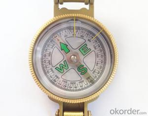

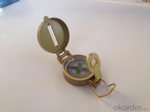


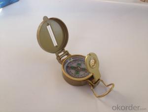
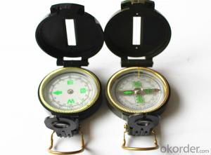
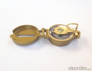
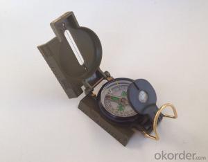
Army or Military Compass DC45-3A
- Ref Price:
-

- Loading Port:
- Tianjin
- Payment Terms:
- TT OR LC
- Min Order Qty:
- -
- Supply Capability:
- 5000 pc/month
OKorder Service Pledge
OKorder Financial Service
You Might Also Like


Model: DC45-3A
Name: outdoor hiking or military compass and army compass, metal compass and marching compass in aluminium material
Product Origin: China
Supply Ability: 40,000 pcs/month
Minimum Order: 100 pcs
MOQ for OEM package: 500pcs
Detailed Product Description
Product Size: 76*53*26 (mm)
Color: Golden
Material: Aluminum alloy
Features:
1)Can easily folds to fit in your pocket
2) The compass is highly accurate and features a liquid-damped compass card with a luminous dial that can easily be read at night, and a standard bezel with two yellow lines at 45 degree angles
3) The compass card has both the standard 0 - 360 degree scale, as well as the 0 - 64Mil scale (one yard at 1,000 yards)
4) The bezel rotates with detents every 3 degrees so you can change the heading reference a known amount without looking at the compass
5) The front sight has a magnifier to simultaneously view the magnetic heading when taking a sight
6) A second magnifier assists in reading the magnetic heading when direct viewing from above
7) When unfolded flat, the marching compass has a straight edge with a standard 1:25,000 or 1:50000 map scale
8) This compass is protected by a durable cast metal case painted dark black with military drab
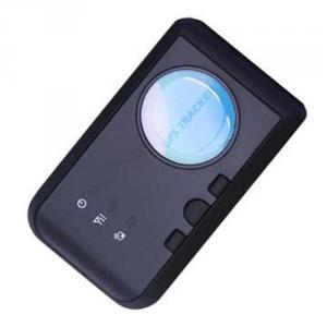
- Q: What is a GPS positioning system?
- GPS system compositionGPS system has three major components, namely, the space constellation, ground monitoring and user equipment. Space constellation in GPS 24 satellites distributed evenly in 6 orbital planes, orbital plane angle relative to the equatorial plane is 55 degrees, the angle between the plane of the orbit is 60 degrees, each satellite orbital plane 90 degrees, either on the satellite orbit plane than in the west adjacent corresponding satellite orbital plane the lead on 30 degrees. The average altitude of the satellite orbit is 20200km, and the satellite running period is 11 hours and 58 minutes. Each satellite every day about 5 hours above the horizon, and at the same time the number of satellites above the horizon varies with time and location are different, can be 4~11; the ground monitoring part of GPS at present mainly by the distribution in 5 ground stations around the world, including the injection station inspection station, master station and information. The space part and ground monitoring part of the GPS is the basis of the navigation and positioning of the system which is widely used by the user, which is controlled by the United States. The user equipment of the GPS is mainly composed of the receiver hardware and processing software. The user receives the GPS satellite signal through the user equipment, obtains the user position, the speed and so on through the signal processing, finally realizes uses GPS to carry on the navigation and the localization goal.
- Q: My mobile phone is Samsung, why can not locate GPS positioning
- According to your description, it is recommended that you try the following:1 shutdown to try to open the phone.2 when the weather is clear, try to search more than 3 satellites, if the search is not possible with the satellite weather, location, buildings.3 if you can not search the satellite, you can download the High German navigation map data packets to the phone, click on the following link http://c.autonavi /club/update/ please try to re map the package.4 if not successful, it is recommended that you download other navigation software to try.
- Q: Mobile GPS positioning official certification 837706606 is true
- Mobile GPS positioning itself is true. Said the positioning of others, it is not necessarily true, there are many people, many. But on the whole can grasp:
- Q: What are the things that need to be paid attention to in the process of using GPS locator
- Locator before using the SIM card must confirm the following points:SIM card is to support mobile Unicom 2G networkThere must be calls and 2G network trafficWant to listen to the SIM card needs to open the caller ID and have a call function, just locate the traffic package can be opened.
- Q: Use method of real carpenter locator
- The main use of GPS:GPS comparison fee battery, the majority of GPS using four alkaline batteries have been available for 20-30 hours, the time on the manual is not very accurate, should pay attention to the use of spare batteries for long periods of time. Most of the GPS has a permanent spare battery, which can ensure that the data in the memory is not lost when there is no battery. Because GPS is not in the direction of the static indicator function, so also carry a small compass is useful. Marker signs, GPS provides a way to the default standard, such as LMK001, memory, although it can be changed into a better remember the name, but it is inconvenient to input, use the arrow to choose the letter very hard, two is generally only a very short English name, such as 6 or 9 the letter is still not good, remember, and then take a small tape recorder / interview record at any time, it is a good idea.
- Q: If the use of GPS positioning products which brand is good?
- 360 is designed for children. Keys are too small, the old man is not convenient to use. Rather than buy a special for the elderly with GPS locator, such as sharp peaks RF-V16 what the wise.
- Q: Does iPad have GPS positioning navigation capabilities?Is there any WiFi version?
- WiFi version of the no, although it can be fixed, but not rely on the GPS signal, but the network signal, so not accurate enoughWifi+3G version of the GPS chip, is the true sense of the GPS
- Q: Samsung mobile g7106 navigation GPS positioning slow what reason
- Dear Samsung users hello:According to your description, GPS can not be determined by many factors, the most important factor is the signal and motion state. In places where satellite signals are poor (e.g., indoor, tunnel, and high rise buildings, etc.), or in a state of motion, GPS is often difficult to locate. Your suggestion:1 use the GPS in an open space and position it as far as possible in a static state (about 5 minutes), and then try to use it in a state of motion.2 if the phone supports A-GPS function, it is recommended to open the function. Method: Set - (more / more general) - Positioning Service - using wireless network - hook (open A-GPS will consume traffic).3 try to replace other location.If the operation after the mobile phone is still not GPS, recommend that you purchase invoice, warranty card and carry it to the Samsung Service Center view.
- Q: The difference between the built-in antenna and external antenna of GPS positioning equipment
- External antenna: separate equipment and antenna device consists of a host, a signal line, power line, this kind of equipment for external signal line, can be placed closer to the sky outside the range, so the signal and stability will be much better, the accuracy will be better.
- Q: Model: Transit strong ET100Fault description: buy to use less than half a year, the last 2 months has been dropping, at first I thought it was a bad signal did not care, by the beginning of a line a few minutes to a few hours, and then to now is the last connection in August 20th, has dropped for 12 days, I went to search not rib. To the star, or the SIM card arrears, another card is also suitable for this kind of situation, dropped call GPS phone tip off. For the cause of the fault analysis and solutions, I think most of the machine is a problem, it is understood that maintenance?
- A line is not good, bad contact, two machines have problems,
Send your message to us
Army or Military Compass DC45-3A
- Ref Price:
-
- Loading Port:
- Tianjin
- Payment Terms:
- TT OR LC
- Min Order Qty:
- -
- Supply Capability:
- 5000 pc/month
OKorder Service Pledge
OKorder Financial Service
Similar products
Hot products


Hot Searches

