
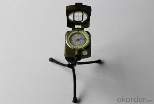
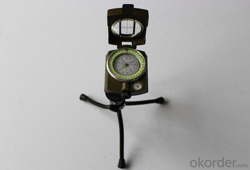


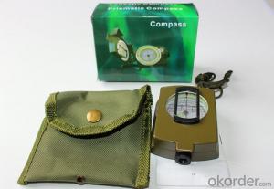
Metal Military and Army Compass D60-2A
- Ref Price:
-

- Loading Port:
- China Main Port
- Payment Terms:
- TT OR LC
- Min Order Qty:
- -
- Supply Capability:
- -
OKorder Service Pledge
OKorder Financial Service
You Might Also Like


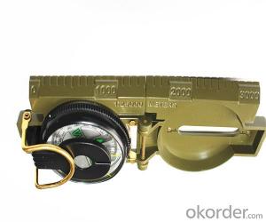
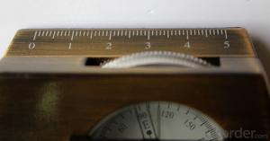
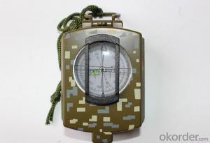
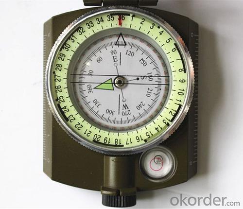
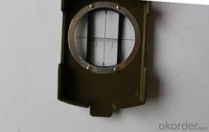
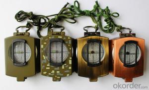
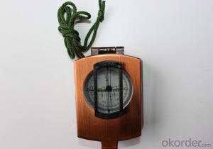
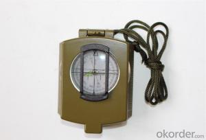
Product details of the compass :
Model: DC60-2A
Name: Military compass, Army compass, Metal compass
Product Origin: China
Supply Ability: 10,000 pcs/month
Minimum Order: 50 pcs
MOQ for OEM package: 500pcs
Shipping of the Compass:
(1)By sea (FOB Tianjin, CIF or other trade terms)
Low shipping cost & slow delivery (7-30days shipping days a different countries , Suitable for container and bulk, at the same time, non-urgent delivery)
(2)By courier express: DHL, FedEx or TNT
Swift delivery (2-5 work days ),but it will cost much .and door to door for the parcel.
Compass Photo:

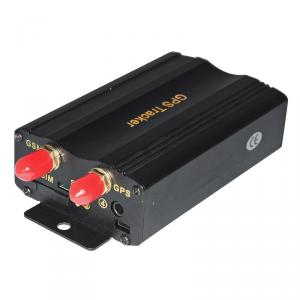
- Q: I heard that the quality GPS locator are similar positioning scheme are the same, Guan Jian in the service platform, our company is doing a good logistics please imagine. Thank you
- As you said the GPS locator hardware are generally similar, but each function is not the same, but if you need to achieve the positioning of the hardware and software need to cooperate with each other, according to their own hardware functionality required for different line, and GPS positioning platform is the most accurate positioning of the main core. Just as long as the platform for people to maintain, a server on the line, more important is the need to constantly upgrade, continue to add new features to the colleagues, also have placed other problems.First of all, you have to avoid the existence of a variety of high-risk vulnerabilities, like the recent exposure of a program company's APP presence of high-risk vulnerabilities, revealing the child's privacy, which is bound to have a significant impactIn fact, as long as the software, there will certainly be loopholes, but found no problems with the discovery, Windows XP available for more than a decade, until now, is still releasing vulnerability patches, but fewer and fewer vulnerabilitiesSimilarly, GPS positioning software is also true, if it is a newly developed software, just released soon, it must be a lot of problems, a lot of problems exist in a variety of sizes,But if the car like a stable life GPS positioning platform Wen Yi run for 4,5 years, the problem will be a lot less, because they are in a continuous optimization and improvement process, the solutions are solved and the optimization and upgrading to more stable when in use.
- Q: How to close millet 3 GPS locator
- Pull down the menu, switch inside the GPS switch
- Q: Children's GPS positioning mobile phone watch need to install a phone card
- It comes with a watch,Is an external card is inserted SIM card.The general is more than the card, do not have the card, personal feel or card is better, then do not want to use the card can also be used on the phone.Currently on the market positioning GPS watches are SIM card positioning, which is the positioning of GPRS, base station positioning.
- Q: FiveFor example, tied in the hands of children, the elderly, the family can see the child through the mobile device, the elderly where they are now. Lost can also find back? But the vast majority of the need for SIM cards, there is no need for a similar SIM card locator? Can you recommend a brand?
- At present, it is impossible to have such a product.After receiving the signal from the GPS satellite, the GPS locator obtains the latitude and longitude information through the software calculation. This information must be sent out to be received by other devices, so that people who need to know the location of the locator get this information. So in the current circumstances, the launch of information, but also with the help of the mobile phone network, there is no other public network can be used, so the phone's SIM card is essential.
- Q: Mobile phone can be tracked after the closure of the GPS?
- Can. Jia trillion mobile phone signal monitoring technology can detect.GPS is the English Global System (Global Positioning System), referred to as Positioning, is currently the most widely used positioning, navigation systems. GPS started in 1958, a project of the U.S. military, put into use in 1964, by the year, the global coverage of up to 98% of the 24 GPS satellite constellation has been completed. Now almost all of the intelligent mobile phone equipped with a GPS service, as long as the open GPS, we can use mobile phone navigation, shooting photos with location information, you can also use some cool and we are related to the position of mobile phone application. In addition, GPS can also help monitor the operation of the vehicle route, the location of the field staff, etc..
- Q: At present, the global positioning system (GPS), vehicle positioning accuracy can be increased to less than 3 meters, if so, what is the theoretical basis? If not, what is the reason?
- We use the accuracy of less than 15 meters, the Americans themselves can be very highThe use of GPS positioning, will be affected by a variety of factors. The factors affecting the accuracy of GPS positioning with GPS satellite can be divided into the following four categories:(1) SA from the U.S. government interests, by reducing the precision of broadcast ephemeris (Technology), adding high frequency jitter in GPS reference signal (Technology) and other methods, reduce the ordinary users using GPS navigation and positioning accuracy.(2) the satellite ephemeris error in GPS positioning, calculation of satellite orbit parameters at a time the GPS satellite position required is provided by various types of [7] ephemeris, but irrespective of the type of ephemeris, the calculated satellite location will be its true position difference, this is the so-called ephemeris error.(3) the satellite clock error of satellite clock error is the error between the installation on the GPS satellite atomic clock clock with GPS standard time.(4) satellite signal transmitting antenna phase center deviation satellite signal transmitting antenna phase center deviation is the difference between the nominal phase center and the true phase center of the signal transmitting antenna on the GPS satellite.
- Q: GPS locator on the flow of electric vehicles and mobile phone traffic can be shared
- Not work. Dissimilarity the locator card and cell phone card is not the same, and then, only 30M traffic locator
- Q: GPS car locator easy to use, useful to share the experience of what I recommend to buy what kind of real
- Xi'an Shaanxi science and technology GPS price is reasonable, cost-effective, good service
- Q: What kind of GPS locator meets the needs of the car loan industry?
- Wired and wireless combined with the best, wired real-time positioning to understand the trend of the car, looking for a wireless car is the key. Rice gm06 and gm08b together, the only choice
- Q: How do the GPS locator offline SLM space
- SIM card for a long time did not use the proposed card replacement
Send your message to us
Metal Military and Army Compass D60-2A
- Ref Price:
-
- Loading Port:
- China Main Port
- Payment Terms:
- TT OR LC
- Min Order Qty:
- -
- Supply Capability:
- -
OKorder Service Pledge
OKorder Financial Service
Similar products
Hot products


Hot Searches

