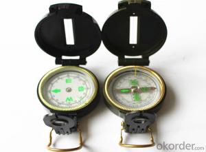


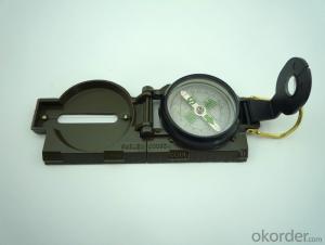
Army Direction Compass 45-1
- Ref Price:
-

- Loading Port:
- China Main Port
- Payment Terms:
- TT OR LC
- Min Order Qty:
- -
- Supply Capability:
- -
OKorder Service Pledge
OKorder Financial Service
You Might Also Like


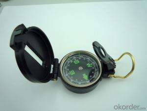
Specifications
Model: DC45-1
Name: outdoor hiking or military compass and army compass, metal compass and marching compass in aluminium material
Product Origin: China
Supply Ability: 40,000 pcs/month
Minimum Order: 100 pcs
MOQ for OEM package: 500pcs
Detailed Product Description
Product Size: 73*55*28 (mm)
Color: Black
Material: Plastic ABS
Features:
1)Can easily folds to fit in your pocket
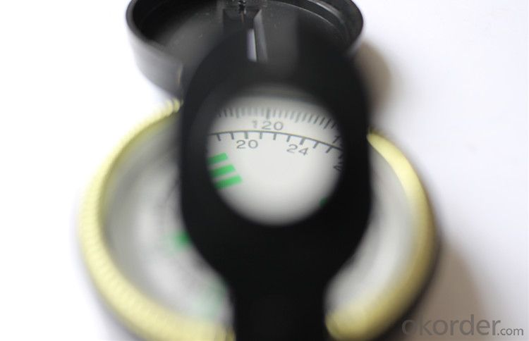
2) The compass is highly accurate and features a liquid-damped compass card with a luminous dial that can easily
be read at night, and a standard bezel with two yellow lines at 45 degree angles
3) The compass card has both the standard 0 - 360 degree scale, as well as the 0 - 64Mil scale (one yard at 1,000 yards)
4) The bezel rotates with detents every 3 degrees so you can change the heading reference a known amount without looking at the compass
5) The front sight has a magnifier to simultaneously view the magnetic heading when taking a sight
6) A second magnifier assists in reading the magnetic heading when direct viewing from above
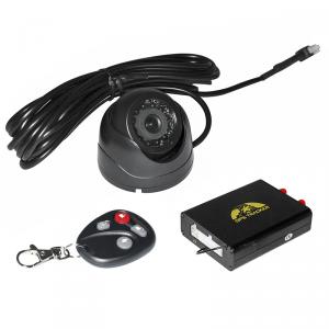
- Q: How to detect whether the car installed jgps locator
- Send in the work of the positioner is GPS signal, you usually have that kind of mobile phone ornaments, that can see signal lights.
- Q: Use GPS positioning a month 3 hours a day with less traffic
- Second: mobile phone GPS, GPS does not need to flow, but the positioning information to be displayed on the map, then see what software you use, because the map is updated in real time online map, map it cost flow, this is the charge flow map refresh, especially for mobile phone navigation software, it depends on how much you load pictures and routes, the number of different loading, the flow is different, you can open one hour traffic statistics look at how much traffic navigation will know.You can try the offline map, so you can avoid trafficNow there are a lot of mobile map navigation, their choice.
- Q: GPS locator to buy a new phone, hang up no positioning messages sent to. But after the call can hear each other's voice. Ask you God, what situation
- I think the GPS locator, or with the function of a little less good, we would have to be accurate positioning, you can, and recently saw a baby in the exhibition in Shenzhen where GPS locator. Position alignment. Fast speed.
- Q: Gps locator user name and password
- General equipment factory will produce a number of IMEI, is a long string of numbers as the account posted on the device, directly into the 15 bit device number can be, except the default password is 123456 individual manufacturers
- Q: Car G P S locator day launch a signal
- Car locator GPS is generally divided into two types, one is connected to the vehicle battery, this is every 10-30 seconds (this time can be set) from a data, in addition there is no connection, OBD and long standby type, OBD is directly connected to the car OBD interface, data transmission frequency and wiring the same, there is generally a day long standby to send a data, or four a day, the customer can set up their own, can also upload the data set into continuous when looking for a car, I hope to help you!
- Q: Does iPad have GPS positioning navigation capabilities?Is there any WiFi version?
- This is not iPad, no GPS module, can not use the localization of GPS, but you can use the A -GPS to locate, need to use the network, so WiFi can not be achieved, cellular version, you can use cellular data card positioning and navigation.
- Q: Where to sell mobile phone GPS locator
- If your phone is a smart phone, you can download a GPS navigation system
- Q: How to use the vehicle GPS positioning system
- Install GPS positioning device to the car, you can locate and monitor the vehicle through the positioning platform or mobile phone app.
- Q: What is the positioning mode of the UUGPS tracking locator?
- This brand of products is produced in Shenzhen, China Science and Technology Industrial Co., ltd.!!!
- Q: Method of use of GPS
- 2 no map use. 1) the use of road point: commonly used to determine the coordinates, to determine the rock caves as starting point, line or other coordinates, the coordinates of the point of turning. Easy to use, MARK a coordinate on the line. Find a point: to find the location must have to sign (landmark/waypoint) exists in the form of GPS in the memory, you can MARK or from previously visited a friend to get data, manual / computer into sign data upload. Press the GOTO key to select your destination from the list, and then go to the "guide" page, which will show you away from the target distance, speed, direction of the target angle and other data, according to the direction angle can be. 2) use the route input route: if you can find the route information recorded by the previous friends, type them into the GPS to form a line, or (usually return to the original road) to edit the previously recorded road sign into a line. Route guidance: put a route according to the activation, and looking for "the same way," guidance "page will lead you to the first point, the route once arrived, the target will automatically replace the next road," guidance "page to lead you to the line of second points if you deviate from... The route over some intermediate point, once you go back to the line," targeting "you will skip around those points, for your current position corresponding to the next point on the line. 3) backtracking is actually a special method of input line (route), it is very easy to return to the original path.
Send your message to us
Army Direction Compass 45-1
- Ref Price:
-
- Loading Port:
- China Main Port
- Payment Terms:
- TT OR LC
- Min Order Qty:
- -
- Supply Capability:
- -
OKorder Service Pledge
OKorder Financial Service
Similar products


Hot products


Hot Searches

