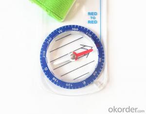


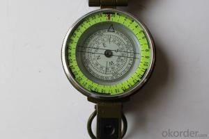
Rugged Mapping Compass with Different Scales
- Ref Price:
-

- Loading Port:
- Tianjin
- Payment Terms:
- TT OR LC
- Min Order Qty:
- 50 pc
- Supply Capability:
- 5000 pc/month
OKorder Service Pledge
OKorder Financial Service
You Might Also Like

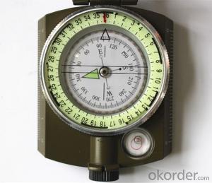
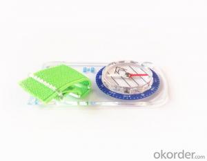
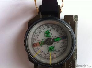
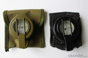
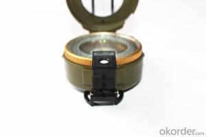
Model: Compass DC35F
Name: Professional map compass, ruler compass
Product Origin: China
Supply Ability: 10,000 pcs/month
Minimum Order: 50 pcs
MOQ for OEM package: 500pcs
Product Size: 90*46*10 (mm)
Features of Compass DC35F:
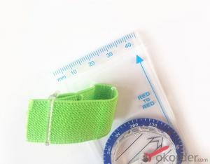
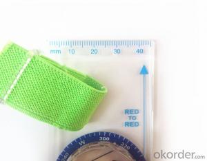
1, professional usage: orientation, distance measuring, measuring slope, azimuth and pitching Angle measurement, drawing, a magnifying glass
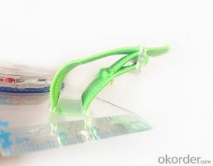
2, high quality compass with neck rope, portable and rugged
3, ACRYLIC material, about 2mm thick
4, Damping Dial: to keep the stability of the pointer, more suitable for outdoor
environment.
5, Accuracy: accurate and clear, there were 360 degrees azimuth Angle, outer ring is 64-00 system, Liquid filled in the compass for reliable readings.
6, Magnifier function
5, with ruler on compass DC35F,
6,for map measure and drawing
7,one meter neck rope,
8,Liquid filled in the compass for reliable readings,
9,Magnifier function.
10,Support OEM
- Q: Portable navigator can not boot, how to solve? Click on the screen does not respond.
- There is what I would like to recommend the use of mobile navigation, more convenient to use, but also free of charge, such as Baidu maps, Google maps.
- Q: Portable navigation which is good
- In the choice of navigation, do not blindly believe that the so-called brand. The key is to choose a suitable for their own.
- Q: About 1000 yuan or less, if it is particularly good, then say more than $1000, I hope to buy their own people say, thank you
- MiTAC: quality is very good, but the four-dimensional map is rubbishI swam: good quality, but also by four-dimensional map search method is much better than MioNewman: the cottage in the brandCityonmap: good, portable, DVD hasRoad through: the map is good, but the price is not cheapKelid: the map is good, but can not get rid of the bad habit of plagiarism, sooner or later will be sealed, the introduction of the marketMalata: choose a not very good machine, and the balance between copycat brands, not genuine map, can hold multiple collocation is a road, a Kay a cityonmap.
- Q: Portable navigation sucker is always out of
- You can change the owner of the suction cup can be made of rubber or hard to change in the hope that I would like to help you wish you a happy [car questions asked the division of 4S professional technicians to solve 10 minutes]
- Q: Why portable navigator must insert card
- Because the card has a map software, if there is no card can not run the map, so there will be no navigation significance.
- Q: Do not require a map, the map can be used to intercept the simulator.I want to capture the navigation menu interface.
- Into the system, it is generally CE bar, run the screenshot software, such as RESCO PHOTO, he will delay 10 seconds to intercept the current screen tomb, switch to the menu interface,
- Q: Portable navigation Kay map with what version?
- So you say, portable navigator is not a true portable navigation, portable navigation and PDA size is almost, slightly larger than the phone. You should use the GPS navigator, the screen from 3.5 inches to 7 inches. GPS navigator generally uses the CE system, and the use of navigation systems used by the vehicle is almost the same, so part of the map can be generic.
- Q: Portable navigation how to download movies
- Do not recommend Bluetooth DownloadWith its own function - the chain - Download - MP3 can be.Recommended to choose more than 10000 Yue yue"
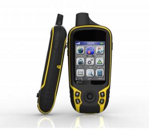
- Q: German born GPS measuring instrument and ziphah handheld measuring instrument Mu Mu which good?
- display along the land around it can measure the size and graphics trajectory, free set the size of Mu mountain woodland slope area can be measured, 400, host size than the cigarette case is long, portable, handheld GPS land area measuring instrument, altitude, speed measurement.
- Q: How much do you want to buy a portable navigator?
- This is to see the quality of navigation as well as their own requirements for navigation
Send your message to us
Rugged Mapping Compass with Different Scales
- Ref Price:
-
- Loading Port:
- Tianjin
- Payment Terms:
- TT OR LC
- Min Order Qty:
- 50 pc
- Supply Capability:
- 5000 pc/month
OKorder Service Pledge
OKorder Financial Service
Similar products


Hot products
Hot Searches

