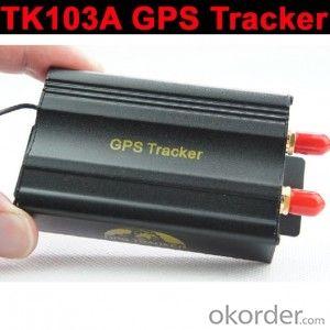

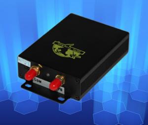
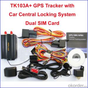
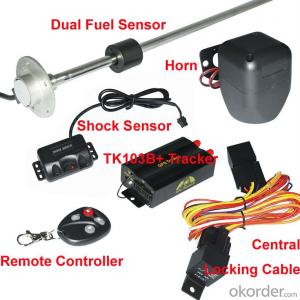
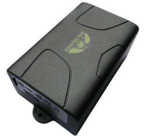
TK103 GPS Tracker Support Stop engine, SD Card, External antenna
- Ref Price:
-

- Loading Port:
- China Main Port
- Payment Terms:
- TT OR LC
- Min Order Qty:
- -
- Supply Capability:
- -
OKorder Service Pledge
OKorder Financial Service
You Might Also Like
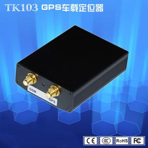


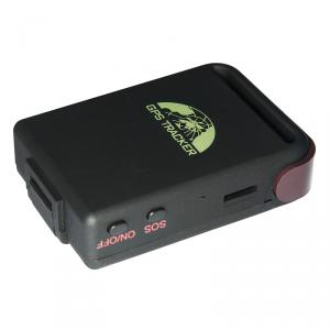
TK103 GPS Tracker Support Stop engine, SD Card, External antenna
Summarize:
Working based on existing GSM/GPRS network and GPS satellites, this product can locate can monitor any remote targets by SMS or internet service platform
Features:
Support non-Server based location
Location memorization
Auto location report
Authorize/delete the tracking phone number
Covert alert& voice surveillance
Geofence:alert in case of braching the predefined district
Movement alert: alert in case of movement
Speed alert: alter in case of excess of the predefined speed
Power alert
Applications:
Vehicle rental/Fleet management ect
Adsorbing in the hidden place of car
Protect car/vehicle/truck,ect
Manage personnel
Specs:
Network: GSM/GPRS
Band: 850/900/1800/1900Mhz
GSM/GPRS sensitivity: -159dBm
GPS accuracy: 5-10m
Time to first fix: cold status 45s; Warm Status: 35s; Hot status 1s
Car charger: 12-24V input; 5V output
Wall charger: 110-220V input; 5V output
Battery: chargeable 3.7V 10000mAh Li-on battery
Standby: 80 hours
Storage temp.:-40.C to +85.C
Operation:-20.C to +55.C
Humidity:5%-95% non-condensing
Dim: 68x46x17mm
N.W/G.W:52g/390G
Gift box: 19x13x5.5cm
Basic functions:
1. GPS + Location based service(LBS)
2, Real time tracking via SMS or GPRS (TCP/UDP)
3, Track on demand by calling or sms comamnd
4, Show location directly on mobile phone with HTTP google map link
5, Track by time and distance interval
6, Five authorized phone number to protect tracker information and assets
7, Voice Surveillance
8, Easy switch for track or Monitor
9, Low battery alarm
10, Power off alarm
11, SOS button for emergency
12, Geo fencing control
13, Overspeed Alarm
14, Engine -cut and restore alarm by SMS GPRS
15, Door, ACC Situation get by SMS
16, Movement alert sensor
17, Free GPRS tracking software send you in CD package
18. With direction and heading value
19. Optional shock/impact sensor
20. Abosolute street function
- Q: Beidou GPS locator and GPS locator difference?
- Beidou satellite navigation and positioning system and their independent research and development GPS don't beauty global positioning navigation system Beidou +GPS dual-mode positioning terminal refers to support Beidou satellite positioning GPS satellite positioning more strictly defined support two systems with help terminal positioning positioning terminalPush with independent intellectual property rights of the Beidou satellite navigation system in front of my terminal positioning system consists of GPS exclusive 2000 I launch the Beidou satellite Beidou satellite navigation system was gradually established and in 201212 month 27 announced the Beidou System spatial signal interface control document type version began in Asia Pacific region to provide source location, navigation, I fired 16 total service award Beidou satellite atThe area of GPS and Beidou short internal GPS signal is weak or some special military area near the shield can compare when the exhibition effect of Beidou Beidou civil service precision of 10 meters of new generation chip has been upgraded to 2.5 meters sea level but also enhance the accuracy of the Beidou 3 cm beyond GPS5~10 meters at present only 16 civilian precision Beidou satellite positioning weaknesses in Southeast Asia;
- Q: How to cancel my Samsung mobile phone GPS positioning
- Set menu. Enter the settings - positioning service --GPS-- can be canceled
- Q: Use method of real carpenter locator
- 2 the use of this is a more common way of using.1) the use of road point: commonly used to determine the coordinates, to determine the rock caves as starting point, line or other coordinates, the coordinates of the point of turning. Easy to use, MARK a coordinate on the line.Find a point: to find the location must have to sign (landmark/waypoint) exists in the form of GPS in the memory, you can MARK or from previously visited a friend to get data, manual / computer into sign data upload. Press the GOTO key to select your destination from the list, and then go to the "guide" page, which will show you away from the target distance, speed, direction of the target angle and other data, according to the direction angle can be.2) the use of input line: if you can find the route route information had been recorded by friends, they enter the GPS forming line, or (in return) to the previously recorded signs edited into a line.Route guidance: put a route according to the activation, and looking for "the same way," guidance "page will lead you to the first point, the route once arrived, the target will automatically replace the next road," second point oriented "page to lead you to the line. If you deviate from the route over some intermediate point, once you go back to the line," targeting "you will skip around those points, for your current position corresponding to the next point on the line.
- Q: Just burglary was not a very expensive mountain bike, intends to buy a car with GPS, please recommend a few easy to use micro GSP locator, a treasure on the more complex, a few requirements:As small as possible, the mountain car is not easy to hide.Life as long as possible, 35 days a charge that is not convenient to use.Don't seven hundred or eight hundred ha, cheap point.
- Pro, after all, electronic products, GPS devices require GPS module, communication module, processing module and battery, so do not do too small.But now there are GPS children watch, there are more subtle GPS positioning shoes, a lot of online selling, you can Baidu: a treasure net to see.Just a few hundred, remember to software client, account and password.You can shop three,General GPS terminal (about 400 yuan) + a traffic card (opened a package of $5 a year) + software (see if it is free). Each fee is different, but generally 500 - 600 get.In fact, GPS equipment general strategies, mainly to see the software, convenient to use, you have to function, you can also see the two. Try software features, look at the map.Pro, my answer is helpful to you ah
- Q: What is the car anti-theft locator?
- Tunnel jGHMy friend recommended me to use Teng Shield SecurityKA
- Q: GPS locator can hear the sound?
- Some devices have a monitoring function, oh, depending on the specific model of some models are not
- Q: How to find mobile phone GpS satellite positioning car
- The third step: wiringAfter installed card, back to the first step. Installation of a variety of color line order to ensure that the connector is not loose, not water. Please use the connection process auto circuit wiring method standard, do not do things carelessly. Wiring processing is not good, on the one hand, it is easy to make the GPS locator power fail to work, there are some short circuit fire safety risks.
- Q: How do the GPS locator offline SLM space
- Empty SIM card should not to stop for a long time, number receiving recommended replacement card shift Xingnuo tech consulting
- Q: Method of use of GPS
- 2 no map use. 1) the use of road point: commonly used to determine the coordinates, to determine the rock caves as starting point, line or other coordinates, the coordinates of the point of turning. Easy to use, MARK a coordinate on the line. Find a point: to find the location must have to sign (landmark/waypoint) exists in the form of GPS in the memory, you can MARK or from previously visited a friend to get data, manual / computer into sign data upload. Press the GOTO key to select your destination from the list, and then go to the "guide" page, which will show you away from the target distance, speed, direction of the target angle and other data, according to the direction angle can be. 2) use the route input route: if you can find the route information recorded by the previous friends, type them into the GPS to form a line, or (usually return to the original road) to edit the previously recorded road sign into a line. Route guidance: put a route according to the activation, and looking for "the same way," guidance "page will lead you to the first point, the route once arrived, the target will automatically replace the next road," guidance "page to lead you to the line of second points if you deviate from... The route over some intermediate point, once you go back to the line," targeting "you will skip around those points, for your current position corresponding to the next point on the line. 3) backtracking is actually a special method of input line (route), it is very easy to return to the original path.
- Q: Car positioning display offline is how
- The vehicle off-line common reasons are the following: 1, the SIM GPS locator card money; 2, your car is in a signal blind area, equipment can not upload information; communication module 3, GPS locator (GSM module) problem; 4, the GPS antenna is broken; 5, no electricity equipment; 6 the GPS module, can not set a lower sensitivity. For a few reasons
Send your message to us
TK103 GPS Tracker Support Stop engine, SD Card, External antenna
- Ref Price:
-
- Loading Port:
- China Main Port
- Payment Terms:
- TT OR LC
- Min Order Qty:
- -
- Supply Capability:
- -
OKorder Service Pledge
OKorder Financial Service
Similar products
Hot products
Hot Searches
Related keywords

